Randonnée Marche Steinbach - Rando CLAS du 02/11/2023 - Photo

Rando CLAS du 02/11/2023

 boubou68
boubou68

Utilisateur

© OpenStreetMap contributors
Longueur
Longueur
17,7 km
Altitude max
Altitude max
917 m
Dénivelé positif
Dénivelé positif
697 m
Km-Effort
Km-Effort  
27 km
Altitude min
Altitude min
327 m
Dénivelé négatif
Dénivelé négatif
697 m
Boucle
Boucle
Oui
Date de création :
2023-11-02 08:05:05.046
Dernière modification :
2023-11-02 14:21:26.379

(0 Avis)

Marche
Marche
4h35
Difficulté : Très difficile

Scannez ce code QR pour ouvrir la randonnée dans l'application SityTrail

Application GPS de randonnée GRATUITE

Logo SityTrail SityTrail

IGN / Instituts géographiques

Télécharger SityTrail sur l'App Store Télécharger SityTrail sur Google Play

Logo SityTrail SityTrail World

Le monde est à vous

Télécharger SityTrail sur l'App Store Télécharger SityTrail sur Google Play Télécharger SityTrail sur Huawei AppGallery

À propos

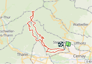
Randonnée Marche de 17,7 km à découvrir à Grand Est, Haut-Rhin, Steinbach. Cette randonnée est proposée par boubou68.

Description

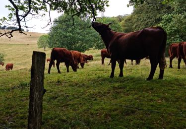
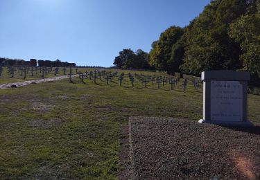
Rando bien pluvieuse en matinée " les gentils canards" qui m'ont accompagné  étaient ravis de se retrouver.!!
Abri Becherkopf plein à notre arrivée...nous avons déjeuné au grand air..
Plus de pluie l'après midi...
Le vent pratiquement absent.
Un grand merci à les compagnons de route.

Profil altimétrique

Photos

Localisation

Pays :
France
Région :
Grand Est
Département/Province :
Haut-Rhin
Commune :
Steinbach
Localité :
Unknown
Départ:(UTM)
362176 ; 5297298 (32T) N.

Randonnées à proximité

Randonnée Marche Soultz-Haut-Rhin - Hartmannswillerkopf - Circuit découverte - Photo
Marche
VacheKiri67

Marche

Facile
(1)
Soultz-Haut-Rhin, Grand Est, Haut-Rhin, France
3,6 km | 5,2 km-effort
1h 46min
Oui
Randonnée Marche Soultz-Haut-Rhin - Hartmannswillerkopf - Circuit anneau bleu - Photo
Marche
VacheKiri67

Marche

Moyen
(1)
Soultz-Haut-Rhin, Grand Est, Haut-Rhin, France
3,7 km | 5,9 km-effort
1h 37min
Oui
Randonnée Autre activité Steinbach - lac du ballon - Photo
Autre activité
rodabruna

Autre activité

Très facile
(1)
Steinbach, Grand Est, Haut-Rhin, France
33 km | 64 km-effort
5h 1min
Non
Randonnée Trail Wattwiller - The History Ultra - Stage 1 - Photo
Trail
Olivier Houette

Trail

Très facile
(1)
Wattwiller, Grand Est, Haut-Rhin, France
28 km | 48 km-effort
Inconnu
Non
Randonnée Marche Thann - JD 14/20 Thann-roche--albert--grumbachkopf - Photo
Marche
argonneuweg

Marche

Moyen
(1)
Thann, Grand Est, Haut-Rhin, France
7,6 km | 12 km-effort
2h 28min
Oui
Randonnée Marche Uffholtz - Molkenrain 1 - Photo
Marche
regisbodilis

Marche

Difficile
(1)
Uffholtz, Grand Est, Haut-Rhin, France
15,4 km | 26 km-effort
4h 0min
Oui
Randonnée Marche Steinbach - Rando Marcheurs du 03/07/2023 par ALAIN - Photo
Marche
boubou68

Marche

Très difficile
Steinbach, Grand Est, Haut-Rhin, France
20 km | 34 km-effort
5h 1min
Oui
Randonnée Marche Wattwiller - Wattwiller - Domaine du Hirtz (30/03/2023) - Photo
Marche
Richard68500

Marche

Facile
Wattwiller, Grand Est, Haut-Rhin, France
6,1 km | 9,9 km-effort
2h 7min
Oui
Randonnée Vélo de route Cernay - Le Grand ballon de Cernay  - Photo
Vélo de route
nadd73

Vélo de route

Difficile
Cernay, Grand Est, Haut-Rhin, France
23 km | 36 km-effort
2h 15min
Non


Fermer
Mes abonnements