Randonnée Marche Vaals - Vaals 13,3km - Photo
© OpenStreetMap contributors
Longueur
Longueur
13,3 km
Altitude max
Altitude max
351 m
Dénivelé positif
Dénivelé positif
328 m
Km-Effort
Km-Effort  
17,7 km
Altitude min
Altitude min
197 m
Dénivelé négatif
Dénivelé négatif
329 m
Boucle
Boucle
Oui
Date de création :
2014-12-10 00:00:00.0
Dernière modification :
2014-12-10 00:00:00.0

(4 Avis)

Marche
Marche
--
Difficulté : Inconnu

Scannez ce code QR pour ouvrir la randonnée dans l'application SityTrail

Application GPS de randonnée GRATUITE

Logo SityTrail SityTrail

IGN / Instituts géographiques

Télécharger SityTrail sur l'App Store Télécharger SityTrail sur Google Play

Logo SityTrail SityTrail World

Le monde est à vous

Télécharger SityTrail sur l'App Store Télécharger SityTrail sur Google Play Télécharger SityTrail sur Huawei AppGallery

À propos

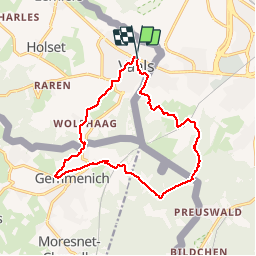
Randonnée Marche de 13,3 km à découvrir à Limbourg, Inconnu, Vaals. Cette randonnée est proposée par wandelgidszuidlimburg.

Description

More information on : http://www.wandelgidszuidlimburg.com

Profil altimétrique

Points d'intérêt

Point d'intérêt Vaals - Start - Photo
wandelgidszuidlimburg
VAALS 

Localisation

Pays :
Pays-Bas
Région :
Limbourg
Département/Province :
Inconnu
Commune :
Vaals
Localité :
Unknown
Départ:(Dec)
Départ:(UTM)
289817 ; 5628780 (32U) N.

Commentaires

Veuillez vous connecter pour laisser un commentaire ou une note


Une rando 🥾 Trois pays 🇧🇪🇩🇪🇳🇱 Magnifique parcours. Pour nous, départ de Gemmenich. ℹ n° 691.


superbe balade riche et paysages diversifiés


Superbe balade entre 3 frontières et paysages très variés


superbe survol des 3 frontières


Randonnées à proximité

Randonnée Marche Vaals - Lemiers _788 - Photo
Marche
GUIDE
mumu.larandonneuse

Marche

Moyen
(1)
Vaals, Limbourg, Inconnu, Pays-Bas
12,9 km | 16,3 km-effort
3h 42min
Oui
Randonnée Marche Vaals - Lemiers _235 - Photo
Marche
GUIDE
mumu.larandonneuse

Marche

Moyen
(1)
Vaals, Limbourg, Inconnu, Pays-Bas
14,7 km | 18,3 km-effort
4h 9min
Oui
Randonnée Marche Aix-la-Chapelle - Aix-la-Chapelle  - Photo
Marche
GUIDE
mumu.larandonneuse

Marche

Facile
(1)
Aix-la-Chapelle, Rhénanie-du-Nord-Westphalie, Région urbaine d'Aix-la-Chapelle, Allemagne
11,4 km | 15,4 km-effort
3h 30min
Oui
Randonnée Marche Vaals - Wandelroute---cittaslow-rondje-viele - Photo
Marche
GUIDE
mumu.larandonneuse

Marche

Moyen
(1)
Vaals, Limbourg, Inconnu, Pays-Bas
12,8 km | 17,1 km-effort
3h 53min
Oui
Randonnée Marche Vaals - Vaals_1431 - Photo
Marche
GUIDE
mumu.larandonneuse

Marche

Moyen
(1)
Vaals, Limbourg, Inconnu, Pays-Bas
13,1 km | 16,6 km-effort
3h 46min
Oui
Randonnée Marche La Calamine - 20200730 - Les 3 Bornes 7.3 Km - Photo
Marche
GUIDE
pierreh01

Marche

Difficile
(1)
La Calamine, Wallonie, Liège, Belgique
7,4 km | 10,4 km-effort
1h 50min
Oui
Randonnée Marche La Calamine - Venn Trilogie (1er étape) - Photo
Marche
Godasses et Grosses Pattes

Marche

Moyen
(1)
La Calamine, Wallonie, Liège, Belgique
25 km | 30 km-effort
5h 0min
Non
Randonnée Marche Plombières - Promenade du Vieux Moulin (9,5km) - Photo
Marche
GUIDE+

Marche

Très facile
(2)
Plombières, Wallonie, Liège, Belgique
8,3 km | 11 km-effort
Inconnu
Oui
Randonnée Marche Plombières - Promenade Köning-Rabenpfuhl (10km) - Photo
Marche
GUIDE+

Marche

Très facile
(1)
Plombières, Wallonie, Liège, Belgique
9,5 km | 12,3 km-effort
Inconnu
Oui


Fermer
Mes abonnements