Randonnée Marche Saint-Jean-Cap-Ferrat - w-frankrijk-tour-du-cap-ferrat - Photo
 gpstracks
gpstracks

Utilisateur

© OpenStreetMap contributors
Longueur
Longueur
6,5 km
Altitude max
Altitude max
57 m
Dénivelé positif
Dénivelé positif
156 m
Km-Effort
Km-Effort  
8,6 km
Altitude min
Altitude min
0 m
Dénivelé négatif
Dénivelé négatif
157 m
Boucle
Boucle
Non
Date de création :
2014-12-10 00:00:00.0
Dernière modification :
2014-12-10 00:00:00.0

(1 Avis)

Marche
Marche
--
Difficulté : Inconnu

Scannez ce code QR pour ouvrir la randonnée dans l'application SityTrail

Application GPS de randonnée GRATUITE

Logo SityTrail SityTrail

IGN / Instituts géographiques

Télécharger SityTrail sur l'App Store Télécharger SityTrail sur Google Play

Logo SityTrail SityTrail World

Le monde est à vous

Télécharger SityTrail sur l'App Store Télécharger SityTrail sur Google Play Télécharger SityTrail sur Huawei AppGallery

À propos

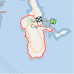
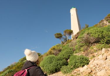
Randonnée Marche de 6,5 km à découvrir à Provence-Alpes-Côte d'Azur, Alpes-Maritimes, Saint-Jean-Cap-Ferrat. Cette randonnée est proposée par gpstracks.

Description

More information on GPStracks.nl : http://www.gpstracks.nl

Profil altimétrique

Points d'intérêt

Point d'intérêt Saint-Jean-Cap-Ferrat - START - Photo
gpstracks
SAINT-JEAN-CAP-FERRAT 

Localisation

Pays :
France
Région :
Provence-Alpes-Côte d'Azur
Département/Province :
Alpes-Maritimes
Commune :
Saint-Jean-Cap-Ferrat
Localité :
Unknown
Départ:(Dec)
Départ:(UTM)
366014 ; 4838569 (32T) N.

Commentaires

Veuillez vous connecter pour laisser un commentaire ou une note


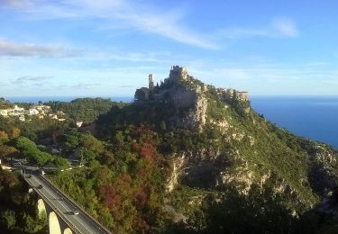
Le sentier du littoral est magnifique


Randonnées à proximité

Randonnée Marche Nice - Ballade chemin des douaniers Nice-Villefranche  - Photo
Marche
coriace

Marche

Très facile
(1)
Nice, Provence-Alpes-Côte d'Azur, Alpes-Maritimes, France
7,9 km | 10,3 km-effort
2h 13min
Non
Randonnée Marche Saint-Jean-Cap-Ferrat - Cap Ferrat 2011-10-27 - Photo
Marche
Cricounet84

Marche

Moyen
(2)
Saint-Jean-Cap-Ferrat, Provence-Alpes-Côte d'Azur, Alpes-Maritimes, France
10,9 km | 14 km-effort
4h 0min
Oui
Randonnée A pied Èze - Circuit du mont Bastide - Photo
A pied
PRO

A pied

Facile
Èze, Provence-Alpes-Côte d'Azur, Alpes-Maritimes, France
7 km | 14,7 km-effort
3h 20min
Oui
Randonnée Marche Èze - Mont Bastide, sentier de Nietzsche - Photo
Marche
PEBREJOSIANE

Marche

Facile
(1)
Èze, Provence-Alpes-Côte d'Azur, Alpes-Maritimes, France
7,2 km | 15,1 km-effort
3h 15min
Oui
Randonnée Marche Saint-Jean-Cap-Ferrat - Tour du Cap Ferrat - Photo
Marche
tracegps

Marche

Moyen
(4)
Saint-Jean-Cap-Ferrat, Provence-Alpes-Côte d'Azur, Alpes-Maritimes, France
8,9 km | 11,2 km-effort
2h 0min
Oui
Randonnée Marche Cap-d'Ail - Cap d’ail - Nice Riquier - Photo
Marche
ETMU5496

Marche

Moyen
Cap-d'Ail, Provence-Alpes-Côte d'Azur, Alpes-Maritimes, France
22 km | 35 km-effort
7h 59min
Non
Randonnée Marche Cap-d'Ail - Nice Cap d'Ail en train et retour par les cretes - Photo
Marche
jouans

Marche

Très difficile
Cap-d'Ail, Provence-Alpes-Côte d'Azur, Alpes-Maritimes, France
23 km | 36 km-effort
8h 6min
Non
Randonnée Marche Nice - Nice - Tour du Mont Boron - Photo
Marche
LightStalker

Marche

Facile
Nice, Provence-Alpes-Côte d'Azur, Alpes-Maritimes, France
7,3 km | 10,5 km-effort
2h 48min
Oui
Randonnée Marche Saint-Jean-Cap-Ferrat - Cap Ferrat - Photo
Marche
Jean-François Thibaud

Marche

Moyen
Saint-Jean-Cap-Ferrat, Provence-Alpes-Côte d'Azur, Alpes-Maritimes, France
8,2 km | 11 km-effort
3h 20min
Non


Fermer
Mes abonnements