Randonnée Marche Saint-Jean-Cap-Ferrat - Cap Ferrat - Photo
© OpenStreetMap contributors
Longueur
Longueur
8,2 km
Altitude max
Altitude max
128 m
Dénivelé positif
Dénivelé positif
212 m
Km-Effort
Km-Effort  
11 km
Altitude min
Altitude min
0 m
Dénivelé négatif
Dénivelé négatif
200 m
Boucle
Boucle
Non
Date de création :
2023-01-05 11:19:57.461
Dernière modification :
2023-01-06 18:38:11.444

(0 Avis)

Marche
Marche
3h20
Difficulté : Moyen

Scannez ce code QR pour ouvrir la randonnée dans l'application SityTrail

Application GPS de randonnée GRATUITE

Logo SityTrail SityTrail

IGN / Instituts géographiques

Télécharger SityTrail sur l'App Store Télécharger SityTrail sur Google Play

Logo SityTrail SityTrail World

Le monde est à vous

Télécharger SityTrail sur l'App Store Télécharger SityTrail sur Google Play Télécharger SityTrail sur Huawei AppGallery

À propos

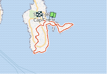
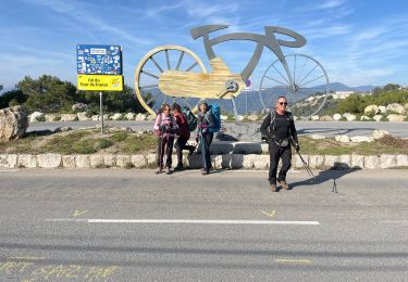
Randonnée Marche de 8,2 km à découvrir à Provence-Alpes-Côte d'Azur, Alpes-Maritimes, Saint-Jean-Cap-Ferrat. Cette randonnée est proposée par Jean-François Thibaud.

Description

Balade écourtée car le sentier du littoral sur la partie ouest du cap était fermé pour cause d'éboulement. Le retour s'est fait en coupant par le sémaphore.

Profil altimétrique

Photos

Localisation

Pays :
France
Région :
Provence-Alpes-Côte d'Azur
Département/Province :
Alpes-Maritimes
Commune :
Saint-Jean-Cap-Ferrat
Localité :
Unknown
Départ:(UTM)
365844 ; 4838577 (32T) N.

Randonnées à proximité

Randonnée Marche Nice - Ballade chemin des douaniers Nice-Villefranche  - Photo
Marche
coriace

Marche

Très facile
(1)
Nice, Provence-Alpes-Côte d'Azur, Alpes-Maritimes, France
7,9 km | 10,3 km-effort
2h 13min
Non
Randonnée Marche Saint-Jean-Cap-Ferrat - Cap Ferrat 2011-10-27 - Photo
Marche
Cricounet84

Marche

Moyen
(2)
Saint-Jean-Cap-Ferrat, Provence-Alpes-Côte d'Azur, Alpes-Maritimes, France
10,9 km | 14 km-effort
4h 0min
Oui
Randonnée A pied Èze - Circuit du mont Bastide - Photo
A pied
PRO

A pied

Facile
Èze, Provence-Alpes-Côte d'Azur, Alpes-Maritimes, France
7 km | 14,7 km-effort
3h 20min
Oui
Randonnée Marche Èze - Mont Bastide, sentier de Nietzsche - Photo
Marche
PEBREJOSIANE

Marche

Facile
(1)
Èze, Provence-Alpes-Côte d'Azur, Alpes-Maritimes, France
7,2 km | 15,1 km-effort
3h 15min
Oui
Randonnée Marche Saint-Jean-Cap-Ferrat - w-frankrijk-tour-du-cap-ferrat - Photo
Marche
gpstracks

Marche

Très facile
(1)
Saint-Jean-Cap-Ferrat, Provence-Alpes-Côte d'Azur, Alpes-Maritimes, France
6,5 km | 8,6 km-effort
Inconnu
Non
Randonnée Marche Saint-Jean-Cap-Ferrat - Tour du Cap Ferrat - Photo
Marche
tracegps

Marche

Moyen
(4)
Saint-Jean-Cap-Ferrat, Provence-Alpes-Côte d'Azur, Alpes-Maritimes, France
8,9 km | 11,2 km-effort
2h 0min
Oui
Randonnée Marche Cap-d'Ail - Cap d’ail - Nice Riquier - Photo
Marche
ETMU5496

Marche

Moyen
Cap-d'Ail, Provence-Alpes-Côte d'Azur, Alpes-Maritimes, France
22 km | 35 km-effort
7h 59min
Non
Randonnée Marche Cap-d'Ail - Nice Cap d'Ail en train et retour par les cretes - Photo
Marche
jouans

Marche

Très difficile
Cap-d'Ail, Provence-Alpes-Côte d'Azur, Alpes-Maritimes, France
23 km | 36 km-effort
8h 6min
Non
Randonnée Marche Nice - Nice - Tour du Mont Boron - Photo
Marche
LightStalker

Marche

Facile
Nice, Provence-Alpes-Côte d'Azur, Alpes-Maritimes, France
7,3 km | 10,5 km-effort
2h 48min
Oui


Fermer
Mes abonnements