62 km | 81 km-effort
Lot - Labastide-Marnhac La Rosiere 14km 250m
RandoVal
Utilisateur
Longueur
13,6 km
Altitude max
305 m
Dénivelé positif
349 m
Km-Effort
18,2 km
Altitude min
163 m
Dénivelé négatif
349 m
Boucle
Oui
Date de création :
2021-05-31 19:28:31.737
Dernière modification :
2021-06-01 16:19:27.788
--
Difficulté : Inconnu
Application GPS de randonnée GRATUITE
À propos
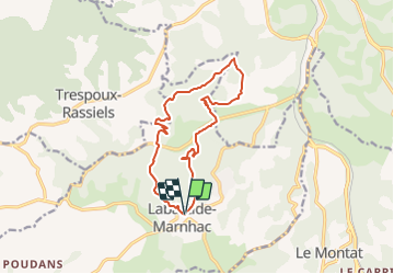
Randonnée Marche de 13,6 km à découvrir à Occitanie, Lot, Labastide-Marnhac. Cette randonnée est proposée par RandoVal.
Description
Petite boucle dans le Lot, stationnement et départ derrière l'église de Labastide-Marnhac, sens horaire.
Localisation
Pays :
France
Région :
Occitanie
Département/Province :
Lot
Commune :
Labastide-Marnhac
Localité :
Unknown
Départ:(Dec)
Départ:(UTM)
372626 ; 4916247 (31T) N.
Commentaires
Randonnées à proximité
Mon Compostelle huitième étape
Marche
Difficile
Labastide-Marnhac,
Occitanie,
Lot,
France
51 km | 65 km-effort
10h 40min
Non
Circuit ouest de Trespoux Rassiels
V.T.T.
Très difficile
Trespoux-Rassiels,
Occitanie,
Lot,
France
38 km | 51 km-effort
4h 15min
Oui
Raid Cahors La Rozière 2006
V.T.T.
Très difficile
Cahors,
Occitanie,
Lot,
France
59 km | 78 km-effort
4h 40min
Oui
Cluzel au temps des bleuets
Marche
Très facile
Labastide-Marnhac,
Occitanie,
Lot,
France
10,2 km | 11,7 km-effort
2h 9min
Oui
trail Trèspoux
Course à pied
Très facile
Trespoux-Rassiels,
Occitanie,
Lot,
France
10 km | 13,1 km-effort
1h 14min
Oui
De la Rozière à Labastide-Marnhac
V.T.T.
Moyen
Cahors,
Occitanie,
Lot,
France
17,2 km | 22 km-effort
1h 30min
Oui
De la Rozière à Labastide-Marnhac
Marche
Difficile
Cahors,
Occitanie,
Lot,
France
17,2 km | 22 km-effort
3h 30min
Oui