Tocht Stappen Labastide-Marnhac - Lot - Labastide-Marnhac La Rosiere 14km 250m - Photo

Lot - Labastide-Marnhac La Rosiere 14km 250m

 RandoVal
RandoVal

Gebruiker

© OpenStreetMap contributors
Lengte
Lengte
13,6 km
Max. hoogte
Max. hoogte
305 m
Positief hoogteverschil
349 m
Km-Effort
Km-Effort  
18,2 km
Min. hoogte
Min. hoogte
163 m
Negatief hoogteverschil
349 m
Boucle
Boucle
Ja
Datum van aanmaak :
2021-05-31 19:28:31.737
Laatste wijziging :
2021-06-01 16:19:27.788

(0 Bericht)

Stappen
Stappen
--
Moeilijkheid : Onbekend

Scan deze QR-code om de tocht te openen in de SityTrail-applicatie

Gratisgps-wandelapplicatie

Logo SityTrail SityTrail

IGN / Geografische instituten

SityTrail uit de App Store downloaden SityTrail uit Google Play downloaden

Logo SityTrail SityTrail World

De wereld gaat voor u open

SityTrail uit de App Store downloaden SityTrail uit Google Play downloaden SityTrail op Huawei AppGallery downloaden

Over ons

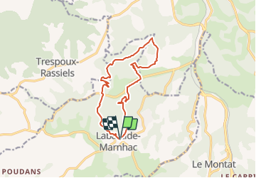
Tocht Stappen van 13,6 km beschikbaar op Occitanië, Lot, Labastide-Marnhac. Deze tocht wordt voorgesteld door RandoVal.

Beschrijving

Petite boucle dans le Lot, stationnement et départ derrière l'église de Labastide-Marnhac, sens horaire.

Hoogteprofiel

Plaatsbepaling

Land:
France
Regio :
Occitanië
Departement/Provincie :
Lot
Gemeente :
Labastide-Marnhac
Locatie:
Unknown
Vertrek:(Dec)
Vertrek:(UTM)
372626 ; 4916247 (31T) N.

Wandeltochten in de omgeving

Tocht Mountainbike Cahors - Cahors-La Rozière 2005 - Photo
Mountainbike
tracegps

Mountainbike

Zeer moeilijk
(1)
Cahors, Occitanië, Lot, France
62 km | 81 km-effort
5h 0min
Ja
Tocht Stappen Labastide-Marnhac - Mon Compostelle huitième étape - Photo
Stappen
Ardeiserois

Stappen

Moeilijk
Labastide-Marnhac, Occitanië, Lot, France
51 km | 65 km-effort
10h 40min
Neen
Tocht Mountainbike Trespoux-Rassiels - Circuit ouest de Trespoux Rassiels - Photo
Mountainbike
tracegps

Mountainbike

Zeer moeilijk
Trespoux-Rassiels, Occitanië, Lot, France
38 km | 51 km-effort
4h 15min
Ja
Tocht Mountainbike Cahors - Raid Cahors La Rozière 2006 - Photo
Mountainbike
tracegps

Mountainbike

Zeer moeilijk
Cahors, Occitanië, Lot, France
59 km | 78 km-effort
4h 40min
Ja
Tocht Stappen Labastide-Marnhac - Cluzel au temps des bleuets  - Photo
Stappen
GUIDE
antignacs

Stappen

Heel gemakkelijk
Labastide-Marnhac, Occitanië, Lot, France
10,2 km | 11,7 km-effort
2h 9min
Ja
Tocht Stappen Labastide-Marnhac - Cluzel 3 - Photo
Stappen
GUIDE
antignacs

Stappen

Medium
Labastide-Marnhac, Occitanië, Lot, France
8,4 km | 10 km-effort
1h 40min
Ja
Tocht Lopen Trespoux-Rassiels - trail Trèspoux - Photo
Lopen
enzodurand

Lopen

Heel gemakkelijk
Trespoux-Rassiels, Occitanië, Lot, France
10 km | 13,1 km-effort
1h 14min
Ja
Tocht Mountainbike Cahors - De la Rozière à Labastide-Marnhac - Photo
Mountainbike
tracegps

Mountainbike

Medium
Cahors, Occitanië, Lot, France
17,2 km | 22 km-effort
1h 30min
Ja
Tocht Stappen Cahors - De la Rozière à Labastide-Marnhac - Photo
Stappen
tracegps

Stappen

Moeilijk
Cahors, Occitanië, Lot, France
17,2 km | 22 km-effort
3h 30min
Ja


Sluiten
Mijn abonnementen