Randonnée A pied Mazamet - mazamet lac des montagnès passerelle mazamet - Photo

mazamet lac des montagnès passerelle mazamet

 Dupleix
Dupleix

Utilisateur

© OpenStreetMap contributors
Longueur
Longueur
14,7 km
Altitude max
Altitude max
746 m
Dénivelé positif
Dénivelé positif
648 m
Km-Effort
Km-Effort  
23 km
Altitude min
Altitude min
292 m
Dénivelé négatif
Dénivelé négatif
649 m
Boucle
Boucle
Oui
Date de création :
2021-07-21 13:34:57.265
Dernière modification :
2021-07-21 13:40:39.101

(0 Avis)

A pied
A pied
5h17
Difficulté : Moyen

Scannez ce code QR pour ouvrir la randonnée dans l'application SityTrail

Application GPS de randonnée GRATUITE

Logo SityTrail SityTrail

IGN / Instituts géographiques

Télécharger SityTrail sur l'App Store Télécharger SityTrail sur Google Play

Logo SityTrail SityTrail World

Le monde est à vous

Télécharger SityTrail sur l'App Store Télécharger SityTrail sur Google Play Télécharger SityTrail sur Huawei AppGallery

À propos

Randonnée A pied de 14,7 km à découvrir à Occitanie, Tarn, Mazamet. Cette randonnée est proposée par Dupleix.

Description

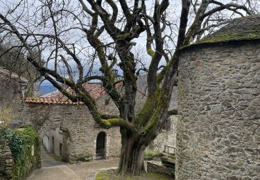
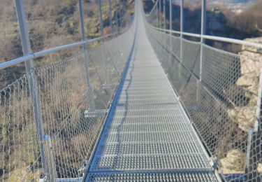
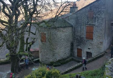
boucle au départ de mmazmet vers le lac des montagnés ou nous prendrons le repas puis descendrons par hautpoul et la passerelle

Profil altimétrique

Localisation

Pays :
France
Région :
Occitanie
Département/Province :
Tarn
Commune :
Mazamet
Localité :
Unknown
Départ:(UTM)
449366 ; 4814344 (31T) N.

Randonnées à proximité

Randonnée Marche Mazamet - Mazamet - Hautpoul - Photo
Marche
tracegps

Marche

Difficile
(1)
Mazamet, Occitanie, Tarn, France
17,4 km | 29 km-effort
6h 30min
Oui
Randonnée Marche Mazamet - Maeamet la passerelle - Photo
Marche
ombrabella

Marche

Moyen
Mazamet, Occitanie, Tarn, France
4,5 km | 8,6 km-effort
1h 32min
Oui
Randonnée Marche Mazamet - Passerelle de Mazamet et village médiéval d'Hautpoul - Photo
Marche
Dominique48

Marche

Difficile
Mazamet, Occitanie, Tarn, France
3,2 km | 6,9 km-effort
1h 41min
Oui
Randonnée V.T.T. Aussillon - Montagne Noire -  Les Montagnès  - Photo
V.T.T.
guillaumepdm

V.T.T.

Difficile
(1)
Aussillon, Occitanie, Tarn, France
29 km | 41 km-effort
2h 49min
Oui
Randonnée Marche Mazamet - depuis HAUPOULet  en 2 boucles - Photo
Marche
chrisgps

Marche

Très facile
Mazamet, Occitanie, Tarn, France
14,2 km | 23 km-effort
6h 6min
Oui
Randonnée Marche Mazamet - Labrespy, Hautpoul, St-Pierre des Plots - Photo
Marche
Jean-Phi81

Marche

Moyen
(1)
Mazamet, Occitanie, Tarn, France
9 km | 13,8 km-effort
3h 1min
Oui
Randonnée Marche Mazamet - Labrespy - la Croix de Prat - Photo
Marche
Jean-Phi81

Marche

Moyen
(1)
Mazamet, Occitanie, Tarn, France
13,8 km | 21 km-effort
4h 35min
Oui
Randonnée V.T.T. Aiguefonde - Balade sur le Causse - Saint Alby    - Photo
V.T.T.
tracegps

V.T.T.

Moyen
Aiguefonde, Occitanie, Tarn, France
29 km | 37 km-effort
3h 0min
Oui
Randonnée V.T.T. Aiguefonde - Les cinq croix - Saint Alby - Photo
V.T.T.
tracegps

V.T.T.

Difficile
Aiguefonde, Occitanie, Tarn, France
38 km | 52 km-effort
4h 0min
Oui


Fermer
Mes abonnements