![](/images/other/stat-length.png)
- Randonnées
- Outdoor
- France
- Occitanie
- Tarn
Tarn, Occitanie : Les meilleures randonnées, itinéraires, parcours, balades et promenades
Tarn : découvrez les meilleures randonnées : 1 732 pédestres, 365 à vélo ou VTT et 17 parcours équestres. Tous ces circuits, parcours, itinéraires et activités en plein air sont disponibles dans nos applications SityTrail pour smartphones et tablettes.
Les meilleurs parcours (2248)
![Randonnée A pied Les Cammazes - Randonnee pedestre aux cammazes - Photo](https://media.geolcdn.com/t/350/260/ext.jpg?maxdim=2&url=https%3A%2F%2Fmedia.geolcdn.com%2Ff%2F8f5a1820-7905-4436-9518-9b288b44909a.jpg)
![A pied A pied](https://static1.geolcdn.com/sitytour/trail-icons/100.png)
Km
A pied
![](/images/other/stat-length.png)
![](https://static1.geolcdn.com/siteimages/upload/files/1508320355ic_sort_den_pos_24dp.png)
![](https://static1.geolcdn.com/siteimages/upload/files/1508320355ic_sort_den_neg_24dp.png)
![](https://static1.geolcdn.com/siteimages/upload/files/16400158638029165_repeat_loop_refresh_sync_direction_icon.png)
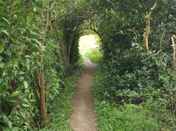
• Randonnée pédestre aux Cammazes dans le Tarn pour une boucle dans la forêt de l'Aiguille. Attention, on ne capte pas ...
![Randonnée Marche Lacrouzette - les rochers de sidobre - Photo](https://media.geolcdn.com/t/350/260/ext.jpg?maxdim=2&url=https%3A%2F%2Fmedia.geolcdn.com%2Ff%2F839edb78-5d91-49a4-b8d5-3785333c8c77.jpg)
![Marche Marche](https://static1.geolcdn.com/sitytour/trail-icons/101.png)
Km
Marche
![](/images/other/stat-length.png)
![](https://static1.geolcdn.com/siteimages/upload/files/1508320355ic_sort_den_pos_24dp.png)
![](https://static1.geolcdn.com/siteimages/upload/files/1508320355ic_sort_den_neg_24dp.png)
![](https://static1.geolcdn.com/siteimages/upload/files/16400158638029165_repeat_loop_refresh_sync_direction_icon.png)
• à faire en famille au fil de l eau. qlq points particuliers avec un peu de ludiques.
![Randonnée Marche Paulinet - sentier des chevreuils - Photo](https://media.geolcdn.com/t/350/260/ext.jpg?maxdim=2&url=https%3A%2F%2Fservices.sitytrail.com%2FGeolivesWS%2FDownloadMedia.ashx%3FTrailID%3D465981%26Media%3Dfix__20150830172016.jpg)
![Marche Marche](https://static1.geolcdn.com/sitytour/trail-icons/101.png)
Km
Marche
![](/images/other/stat-length.png)
![](https://static1.geolcdn.com/siteimages/upload/files/1508320355ic_sort_den_pos_24dp.png)
![](https://static1.geolcdn.com/siteimages/upload/files/1508320355ic_sort_den_neg_24dp.png)
![](https://static1.geolcdn.com/siteimages/upload/files/16400158638029165_repeat_loop_refresh_sync_direction_icon.png)
• En pays dadou
![Randonnée Marche Lisle-sur-Tarn - L'Isle sur Tarn GRP 1 - Photo](https://media.geolcdn.com/t/350/260/ext.jpg?maxdim=2&url=https%3A%2F%2Fservices.sitytrail.com%2FGeolivesWS%2FDownloadMedia.ashx%3FTrailID%3D317785%26Media%3D17101_3.jpg)
![Marche Marche](https://static1.geolcdn.com/sitytour/trail-icons/101.png)
Km
Marche
![](/images/other/stat-length.png)
![](https://static1.geolcdn.com/siteimages/upload/files/1508320355ic_sort_den_pos_24dp.png)
![](https://static1.geolcdn.com/siteimages/upload/files/1508320355ic_sort_den_neg_24dp.png)
![](https://static1.geolcdn.com/siteimages/upload/files/16400158638029165_repeat_loop_refresh_sync_direction_icon.png)
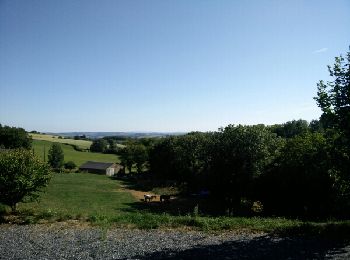
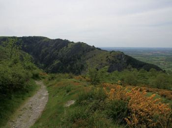
• Très belle balade aux paysages assez diversifiés. Départ du chemin des Monges. De magnifiques panoramas par beau temps.
![Randonnée Marche Penne - Aveyron-121012 - Penne-Bruniquel (txt,gps,foto) - Photo](https://media.geolcdn.com/t/350/260/ext.jpg?maxdim=2&url=https%3A%2F%2Fservices.sitytrail.com%2FGeolivesWS%2FDownloadMedia.ashx%3FTrailID%3D160221%26Media%3D20121012174246.jpeg)
![Marche Marche](https://static1.geolcdn.com/sitytour/trail-icons/101.png)
Km
Marche
![](/images/other/stat-length.png)
![](https://static1.geolcdn.com/siteimages/upload/files/1508320355ic_sort_den_pos_24dp.png)
![](https://static1.geolcdn.com/siteimages/upload/files/1508320355ic_sort_den_neg_24dp.png)
![](https://static1.geolcdn.com/siteimages/upload/files/16400158638029165_repeat_loop_refresh_sync_direction_icon.png)
•
![Randonnée Marche Mazamet - Mazamet - Hautpoul - Photo](https://media.geolcdn.com/t/350/260/ext.jpg?maxdim=2&url=https%3A%2F%2Fservices.sitytrail.com%2FGeolivesWS%2FDownloadMedia.ashx%3FTrailID%3D118725%26Media%3D12918_6.jpg)
![Marche Marche](https://static1.geolcdn.com/sitytour/trail-icons/101.png)
Km
Marche
![](/images/other/stat-length.png)
![](https://static1.geolcdn.com/siteimages/upload/files/1508320355ic_sort_den_pos_24dp.png)
![](https://static1.geolcdn.com/siteimages/upload/files/1508320355ic_sort_den_neg_24dp.png)
![](https://static1.geolcdn.com/siteimages/upload/files/16400158638029165_repeat_loop_refresh_sync_direction_icon.png)
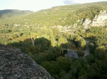
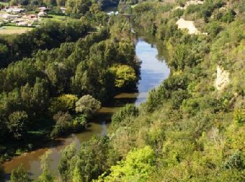
• Au fil de l'eau - Sentiers de l'Arnette industrielle. Le sentier de randonnée « Au fil de l’eau », propose aux randon...
![Randonnée Marche Rabastens - Le sentier du Lac des Lauzerals - Rabastens - Photo](https://media.geolcdn.com/t/350/260/ext.jpg?maxdim=2&url=https%3A%2F%2Fservices.sitytrail.com%2FGeolivesWS%2FDownloadMedia.ashx%3FTrailID%3D104410%26Media%3D7646_6.jpg)
![Marche Marche](https://static1.geolcdn.com/sitytour/trail-icons/101.png)
Km
Marche
![](/images/other/stat-length.png)
![](https://static1.geolcdn.com/siteimages/upload/files/1508320355ic_sort_den_pos_24dp.png)
![](https://static1.geolcdn.com/siteimages/upload/files/1508320355ic_sort_den_neg_24dp.png)
![](https://static1.geolcdn.com/siteimages/upload/files/16400158638029165_repeat_loop_refresh_sync_direction_icon.png)
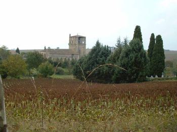
• Au départ de Rabastens pour une rando vallonnée. On arrive vite sous l’Église de Guiddal flanquée de son cimetière, m...
![Randonnée Marche nordique Brens - Brens marche nordique - Photo](https://media.geolcdn.com/t/350/260/ext.jpg?maxdim=2&url=https%3A%2F%2Fmedia.geolcdn.com%2Ff%2Fbfaa5d1b-b099-44b6-a0a6-4ea0552e7cd6.jpg)
![Marche nordique Marche nordique](https://static1.geolcdn.com/sitytour/trail-icons/102.png)
Km
Marche nordique
![](/images/other/stat-length.png)
![](https://static1.geolcdn.com/siteimages/upload/files/1508320355ic_sort_den_pos_24dp.png)
![](https://static1.geolcdn.com/siteimages/upload/files/1508320355ic_sort_den_neg_24dp.png)
![](https://static1.geolcdn.com/siteimages/upload/files/16400158638029165_repeat_loop_refresh_sync_direction_icon.png)
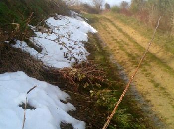
• boucle facile avec un tout-petit dénivelé. une partie bitumée mais sur une petite route sans roulage. sous-bois - che...
![Randonnée Marche Ambialet - Ambialet Couris - Photo](https://media.geolcdn.com/t/350/260/ext.jpg?maxdim=2&url=https%3A%2F%2Fservices.sitytrail.com%2FGeolivesWS%2FDownloadMedia.ashx%3FTrailID%3D619057%26Media%3Dfix__20160822141051.jpg)
![Marche Marche](https://static1.geolcdn.com/sitytour/trail-icons/101.png)
Km
Marche
![](/images/other/stat-length.png)
![](https://static1.geolcdn.com/siteimages/upload/files/1508320355ic_sort_den_pos_24dp.png)
![](https://static1.geolcdn.com/siteimages/upload/files/1508320355ic_sort_den_neg_24dp.png)
![](https://static1.geolcdn.com/siteimages/upload/files/16400158638029165_repeat_loop_refresh_sync_direction_icon.png)
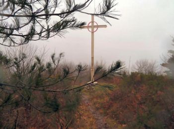
• Jolie randonnée avec des vues inhabituelle sur le prieuré et le village lors du retour. belles vues sur la vallée du...
![Randonnée Marche Dourgne - Désert de St Férréol - Photo](https://media.geolcdn.com/t/350/260/ext.jpg?maxdim=2&url=https%3A%2F%2Fservices.sitytrail.com%2FGeolivesWS%2FDownloadMedia.ashx%3FTrailID%3D110170%26Media%3D5370_1.jpg)
![Marche Marche](https://static1.geolcdn.com/sitytour/trail-icons/101.png)
Km
Marche
![](/images/other/stat-length.png)
![](https://static1.geolcdn.com/siteimages/upload/files/1508320355ic_sort_den_pos_24dp.png)
![](https://static1.geolcdn.com/siteimages/upload/files/1508320355ic_sort_den_neg_24dp.png)
![](https://static1.geolcdn.com/siteimages/upload/files/16400158638029165_repeat_loop_refresh_sync_direction_icon.png)
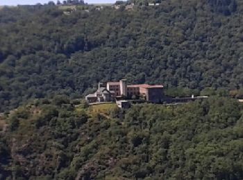
• Une balade au Désert de St Férréol par la vallée du Taurou au dessus de Dourgne dans le Tarn. Randonnée proposée par ...
![Randonnée Marche Giroussens - En forêt de Giroussens - Photo](https://media.geolcdn.com/t/350/260/ext.jpg?maxdim=2&url=https%3A%2F%2Fservices.sitytrail.com%2FGeolivesWS%2FDownloadMedia.ashx%3FTrailID%3D108636%26Media%3D1548_1.jpg)
![Marche Marche](https://static1.geolcdn.com/sitytour/trail-icons/101.png)
Km
Marche
![](/images/other/stat-length.png)
![](https://static1.geolcdn.com/siteimages/upload/files/1508320355ic_sort_den_pos_24dp.png)
![](https://static1.geolcdn.com/siteimages/upload/files/1508320355ic_sort_den_neg_24dp.png)
![](https://static1.geolcdn.com/siteimages/upload/files/16400158638029165_repeat_loop_refresh_sync_direction_icon.png)
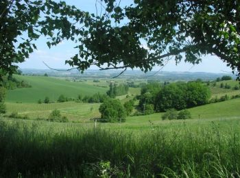
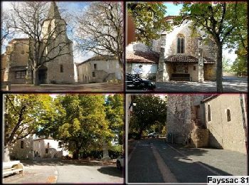
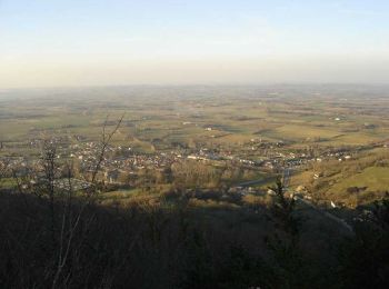
• Giroussens, c'est son église qui remonte au XIII ème siècle. C'est également son beau panorama sur la vallée de l'Ago...
![Randonnée V.T.T. Sorèze - Sorèze - Montagne Noire - Photo](https://media.geolcdn.com/t/350/260/ext.jpg?maxdim=2&url=https%3A%2F%2Fservices.sitytrail.com%2FGeolivesWS%2FDownloadMedia.ashx%3FTrailID%3D100857%26Media%3D354_2.jpg)
![V.T.T. V.T.T.](https://static1.geolcdn.com/sitytour/trail-icons/202.png)
Km
V.T.T.
![](/images/other/stat-length.png)
![](https://static1.geolcdn.com/siteimages/upload/files/1508320355ic_sort_den_pos_24dp.png)
![](https://static1.geolcdn.com/siteimages/upload/files/1508320355ic_sort_den_neg_24dp.png)
![](https://static1.geolcdn.com/siteimages/upload/files/16400158638029165_repeat_loop_refresh_sync_direction_icon.png)
• 25 Janvier 2006 13h30 : tout le monde est à l'heure et tous piaffent d'impatience : c'est la récré du mercredi après-...
![Randonnée Course à pied Teulat - Voir Teulat et courir ! - Photo](https://media.geolcdn.com/t/350/260/ext.jpg?maxdim=2&url=https%3A%2F%2Fservices.sitytrail.com%2FGeolivesWS%2FDownloadMedia.ashx%3FTrailID%3D100628%26Media%3D152_2.jpg)
![Course à pied Course à pied](https://static1.geolcdn.com/sitytour/trail-icons/103.png)
Km
Course à pied
![](/images/other/stat-length.png)
![](https://static1.geolcdn.com/siteimages/upload/files/1508320355ic_sort_den_pos_24dp.png)
![](https://static1.geolcdn.com/siteimages/upload/files/1508320355ic_sort_den_neg_24dp.png)
![](https://static1.geolcdn.com/siteimages/upload/files/16400158638029165_repeat_loop_refresh_sync_direction_icon.png)
• "C'est en se pressant qu'on donne du jus" CITRON II , Vainqueur du semi de Toulouse en l’an 1286, cousin de PEPIN Le ...
![Randonnée Marche Lacrouzette - Sidobre rocs de crémaussel et Lac du Merle 16 kms - Photo](https://media.geolcdn.com/t/350/260/ext.jpg?maxdim=2&url=https%3A%2F%2Fstatic1.geolcdn.com%2Fsiteimages%2Fupload%2Ffiles%2F1553511878bg_sport_marche.png)
![Marche Marche](https://static1.geolcdn.com/sitytour/trail-icons/101.png)
Km
Marche
![](/images/other/stat-length.png)
![](https://static1.geolcdn.com/siteimages/upload/files/1508320355ic_sort_den_pos_24dp.png)
![](https://static1.geolcdn.com/siteimages/upload/files/1508320355ic_sort_den_neg_24dp.png)
![](https://static1.geolcdn.com/siteimages/upload/files/16400158638029165_repeat_loop_refresh_sync_direction_icon.png)
• départ de La Fusarié ( Lacrouzette ) pique nique lac Merle avec aller/retour Peyro Cabado en option
![Randonnée A pied Sorèze - Soreze Oppidum de Berniquaut en boucle. - Photo](https://media.geolcdn.com/t/350/260/ext.jpg?maxdim=2&url=https%3A%2F%2Fstatic1.geolcdn.com%2Fsiteimages%2Fupload%2Ffiles%2F1545311037marcheuse_200dpi.jpg)
![A pied A pied](https://static1.geolcdn.com/sitytour/trail-icons/100.png)
Km
A pied
![](/images/other/stat-length.png)
![](https://static1.geolcdn.com/siteimages/upload/files/1508320355ic_sort_den_pos_24dp.png)
![](https://static1.geolcdn.com/siteimages/upload/files/1508320355ic_sort_den_neg_24dp.png)
![](https://static1.geolcdn.com/siteimages/upload/files/16400158638029165_repeat_loop_refresh_sync_direction_icon.png)
• Magnifique randonnée.
![Randonnée A pied Montredon-Labessonnié - Sentier de la Quille du Roy - Photo](https://media.geolcdn.com/t/350/260/ext.jpg?maxdim=2&url=https%3A%2F%2Fmedia.geolcdn.com%2Ff%2F2f958672-3170-4080-84b8-f6fd5882238e.jpeg)
![A pied A pied](https://static1.geolcdn.com/sitytour/trail-icons/100.png)
Km
A pied
![](/images/other/stat-length.png)
![](https://static1.geolcdn.com/siteimages/upload/files/1508320355ic_sort_den_pos_24dp.png)
![](https://static1.geolcdn.com/siteimages/upload/files/1508320355ic_sort_den_neg_24dp.png)
![](https://static1.geolcdn.com/siteimages/upload/files/16400158638029165_repeat_loop_refresh_sync_direction_icon.png)
• Symbole: yellow bar
![Randonnée A pied Briatexte - Sentier des Crêtes, raccourci des Vignes - Photo](https://media.geolcdn.com/t/350/260/ext.jpg?maxdim=2&url=https%3A%2F%2Fmedia.geolcdn.com%2Ff%2F6d02c86b-f508-4cd2-9c56-4b72a775281b.jpeg)
![A pied A pied](https://static1.geolcdn.com/sitytour/trail-icons/100.png)
Km
A pied
![](/images/other/stat-length.png)
![](https://static1.geolcdn.com/siteimages/upload/files/1508320355ic_sort_den_pos_24dp.png)
![](https://static1.geolcdn.com/siteimages/upload/files/1508320355ic_sort_den_neg_24dp.png)
![](https://static1.geolcdn.com/siteimages/upload/files/16400158638029165_repeat_loop_refresh_sync_direction_icon.png)
• Symbole: yellow bar
![Randonnée A pied Briatexte - Sentier des Crêtes - Photo](https://media.geolcdn.com/t/350/260/ext.jpg?maxdim=2&url=https%3A%2F%2Fmedia.geolcdn.com%2Ff%2F6d02c86b-f508-4cd2-9c56-4b72a775281b.jpeg)
![A pied A pied](https://static1.geolcdn.com/sitytour/trail-icons/100.png)
Km
A pied
![](/images/other/stat-length.png)
![](https://static1.geolcdn.com/siteimages/upload/files/1508320355ic_sort_den_pos_24dp.png)
![](https://static1.geolcdn.com/siteimages/upload/files/1508320355ic_sort_den_neg_24dp.png)
![](https://static1.geolcdn.com/siteimages/upload/files/16400158638029165_repeat_loop_refresh_sync_direction_icon.png)
• Symbole: yellow bar
![Randonnée Vélo électrique Dourgne - Capelette table orientation - Photo](https://media.geolcdn.com/t/350/260/ext.jpg?maxdim=2&url=https%3A%2F%2Fstatic1.geolcdn.com%2Fsiteimages%2Fupload%2Ffiles%2F1524743154velo.jpg)
![Vélo électrique Vélo électrique](https://static1.geolcdn.com/sitytour/trail-icons/205.png)
Km
Vélo électrique
![](/images/other/stat-length.png)
![](https://static1.geolcdn.com/siteimages/upload/files/1508320355ic_sort_den_pos_24dp.png)
![](https://static1.geolcdn.com/siteimages/upload/files/1508320355ic_sort_den_neg_24dp.png)
![](https://static1.geolcdn.com/siteimages/upload/files/16400158638029165_repeat_loop_refresh_sync_direction_icon.png)
• Légère portion de route
![Randonnée Marche Aguts - Aguts boucle du calvaire à Montgey - Photo](https://media.geolcdn.com/t/350/260/ext.jpg?maxdim=2&url=https%3A%2F%2Fstatic1.geolcdn.com%2Fsiteimages%2Fupload%2Ffiles%2F1553511878bg_sport_marche.png)
![Marche Marche](https://static1.geolcdn.com/sitytour/trail-icons/101.png)
Km
Marche
![](/images/other/stat-length.png)
![](https://static1.geolcdn.com/siteimages/upload/files/1508320355ic_sort_den_pos_24dp.png)
![](https://static1.geolcdn.com/siteimages/upload/files/1508320355ic_sort_den_neg_24dp.png)
![](https://static1.geolcdn.com/siteimages/upload/files/16400158638029165_repeat_loop_refresh_sync_direction_icon.png)
• 8,9 km
20 randonnées affichées sur 2248
Application GPS de randonnée GRATUITE
Activités
Régions proches
- Aguts
- Aiguefonde
- Alban
- Albi
- Albine
- Algans
- Almayrac
- Alos
- Amarens
- Ambialet
- Ambres
- Andillac
- Andouque
- Anglès
- Arfons
- Arifat
- Arthès
- Assac
- Aussac
- Aussillon
- Barre
- Belcastel
- Bellegarde-Marsal
- Berlats
- Bernac
- Bertre
- Blan
- Blaye-les-Mines
- Boissezon
- Bournazel
- Bout-du-Pont-de-l'Arn
- Brassac
- Brens
- Briatexte
- Brousse
- Broze
- Burlats
- Busque
- Cabanès
- Cadalen
- Cadix
- Cagnac-les-Mines
- Cahuzac
- Cahuzac-sur-Vère
- Cambon
- Cambon-lès-Lavaur
- Cambounès
- Cambounet-sur-le-Sor
- Campagnac
- Carbes
- Carlus
- Carmaux
- Castanet
- Castelnau-de-Lévis
- Castelnau-de-Montmiral
- Castres
- Caucalières
- Cestayrols
- Cordes-sur-Ciel
- Coufouleux
- Courris
- Crespin
- Crespinet
- Cunac
- Cuq
- Cuq-Toulza
- Curvalle
- Damiatte
- Dénat
- Donnazac
- Dourgne
- Durfort
- Escoussens
- Escroux
- Espérausses
- Fauch
- Fayssac
- Fénols
- Fiac
- Florentin
- Fontrieu
- Fraissines
- Frausseilles
- Fréjairolles
- Fréjeville
- Gaillac
- Garrevaques
- Garrigues
- Gijounet
- Giroussens
- Graulhet
- Grazac
- Guitalens-L'Albarède
- Itzac
- Jonquières
- Jouqueviel
- La Sauzière-Saint-Jean
- Labarthe-Bleys
- Labastide-Gabausse
- Labastide-Rouairoux
- Labastide-Saint-Georges
- Labastide-de-Lévis
- Labessière-Candeil
- Laboulbène
- Laboutarie
- Labruguière
- Lacabarède
- Lacaune
- Lacaze
- Lacougotte-Cadoul
- Lacroisille
- Lacrouzette
- Lagarrigue
- Lagrave
- Lamillarié
- Lamontélarié
- Laparrouquial
- Larroque
- Lasfaillades
- Lasgraisses
- Lautrec
- Lavaur
- Le Bez
- Le Fraysse
- Le Garric
- Le Masnau-Massuguiès
- Le Rialet
- Le Riols
- Le Ségur
- Le Sequestre
- Le Verdier
- Le Vintrou
- Lédas-et-Penthiès
- Lempaut
- Les Cabannes
- Les Cammazes
- Lescure-d'Albigeois
- Lisle-sur-Tarn
- Livers-Cazelles
- Lombers
- Loubers
- Loupiac
- Lugan
- Magrin
- Mailhoc
- Marnaves
- Marssac-sur-Tarn
- Marzens
- Massac-Séran
- Massaguel
- Massals
- Maurens-Scopont
- Mazamet
- Mézens
- Milhars
- Milhavet
- Miolles
- Mirandol-Bourgnounac
- Monestiés
- Mont-Roc
- Montans
- Montauriol
- Montcabrier
- Montdragon
- Montdurausse
- Montels
- Montfa
- Montgaillard
- Montgey
- Montirat
- Montpinier
- Montredon-Labessonnié
- Montrosier
- Moularès
- Moulayrès
- Moulin-Mage
- Mouzens
- Mouzieys-Panens
- Mouzieys-Teulet
- Murat-sur-Vèbre
- Nages
- Navès
- Noailhac
- Noailles
- Orban
- Padiès
- Pampelonne
- Parisot
- Paulinet
- Payrin-Augmontel
- Péchaudier
- Penne
- Peyrole
- Pont-de-l'Arn
- Poudis
- Poulan-Pouzols
- Prades
- Pratviel
- Puybegon
- Puycalvel
- Puycelsi
- Puygouzon
- Puylaurens
- Rabastens
- Rayssac
- Réalmont
- Rivières
- Roquecourbe
- Roquemaure
- Roquevidal
- Rosières
- Rouairoux
- Rouffiac
- Roussayrolles
- Saint-Affrique-les-Montagnes
- Saint-Agnan
- Saint-Amancet
- Saint-Amans-Soult
- Saint-Amans-Valtoret
- Saint-André
- Saint-Beauzile
- Saint-Benoît-de-Carmaux
- Saint-Christophe
- Saint-Cirgue
- Saint-Gauzens
- Saint-Genest-de-Contest
- Saint-Germain-des-Prés
- Saint-Germier
- Saint-Grégoire
- Saint-Jean-de-Marcel
- Saint-Jean-de-Rives
- Saint-Jean-de-Vals
- Saint-Juéry
- Saint-Julien-du-Puy
- Saint-Lieux-lès-Lavaur
- Saint-Marcel-Campes
- Saint-Martin-Laguépie
- Saint-Michel-de-Vax
- Saint-Paul-Cap-de-Joux
- Saint-Pierre-de-Trivisy
- Saint-Salvi-de-Carcavès
- Saint-Salvy-de-la-Balme
- Saint-Sulpice-la-Pointe
- Sainte-Cécile-du-Cayrou
- Sainte-Croix
- Sainte-Gemme
- Saïx
- Saliès
- Salles
- Salvagnac
- Saussenac
- Sauveterre
- Sémalens
- Senaux
- Senouillac
- Sérénac
- Serviès
- Sieurac
- Sorèze
- Soual
- Souel
- Taïx
- Tanus
- Tauriac
- Técou
- Teillet
- Terre-de-Bancalié
- Terssac
- Teulat
- Teyssode
- Tonnac
- Trébas
- Trévien
- Vabre
- Valderiès
- Valdurenque
- Vaour
- Veilhes
- Vénès
- Verdalle
- Viane
- Vielmur-sur-Agout
- Vieux
- Villefranche-d'Albigeois
- Villeneuve-sur-Vère
- Vindrac-Alayrac
- Virac
- Viterbe
- Viviers-lès-Lavaur
- Viviers-lès-Montagnes