Randonnée Vélo de route Faverolles-sur-Cher - Balade autour de Montrichard - Photo
 pauldurand
pauldurand

Utilisateur

© OpenStreetMap contributors
Longueur
Longueur
48 km
Altitude max
Altitude max
129 m
Dénivelé positif
Dénivelé positif
453 m
Km-Effort
Km-Effort  
54 km
Altitude min
Altitude min
53 m
Dénivelé négatif
Dénivelé négatif
494 m
Boucle
Boucle
Non
Date de création :
2021-08-24 12:56:32.0
Dernière modification :
2021-08-24 16:36:02.055

(0 Avis)

Vélo de route
Vélo de route
3h38
Difficulté : Moyen

Scannez ce code QR pour ouvrir la randonnée dans l'application SityTrail

Application GPS de randonnée GRATUITE

Logo SityTrail SityTrail

IGN / Instituts géographiques

Télécharger SityTrail sur l'App Store Télécharger SityTrail sur Google Play

Logo SityTrail SityTrail World

Le monde est à vous

Télécharger SityTrail sur l'App Store Télécharger SityTrail sur Google Play Télécharger SityTrail sur Huawei AppGallery

À propos

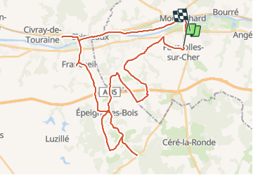
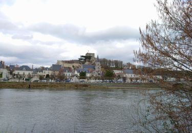
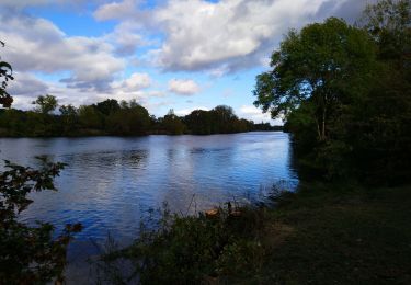
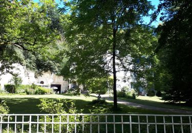
Randonnée Vélo de route de 48 km à découvrir à Centre-Val de Loire, Loir-et-Cher, Faverolles-sur-Cher. Cette randonnée est proposée par pauldurand.

Description

Vu 2 châteaux Chenonceau et Montpoupon

Profil altimétrique

Photos

Localisation

Pays :
France
Région :
Centre-Val de Loire
Département/Province :
Loir-et-Cher
Commune :
Faverolles-sur-Cher
Localité :
Unknown
Départ:(Dec)
Départ:(UTM)
362826 ; 5242848 (31T) N.

Randonnées à proximité

Randonnée Marche Saint-Georges-sur-Cher - Saint-Georges-sur-Cher - GRP Forêt Montrichard - 17.6km 165m 3h40 - 2023 12 27 - Photo
Marche
Orcal37

Marche

Facile
Saint-Georges-sur-Cher, Centre-Val de Loire, Loir-et-Cher, France
17,7 km | 19,8 km-effort
3h 40min
Oui
Randonnée Marche Montrichard Val de Cher - bourre GS 2022 deuxième partie - Photo
Marche
mimilolo

Marche

Moyen
Montrichard Val de Cher, Centre-Val de Loire, Loir-et-Cher, France
6,2 km | 8,6 km-effort
1h 30min
Non
Randonnée Marche Faverolles-sur-Cher - Montrichard - GR41 Forêt GRP - 13.9km 220m 3h30 - 2022 03 03 - Photo
Marche
Orcal37

Marche

Facile
Faverolles-sur-Cher, Centre-Val de Loire, Loir-et-Cher, France
13,9 km | 16,9 km-effort
3h 30min
Oui
Randonnée Marche Saint-Georges-sur-Cher - Saint-Georges-sur-Cher - la Rabotière - 5.9km 50m 1h25 - 2021 12 26 - Photo
Marche
Orcal37

Marche

Très facile
Saint-Georges-sur-Cher, Centre-Val de Loire, Loir-et-Cher, France
5,9 km | 6,6 km-effort
1h 25min
Oui
Randonnée Marche Saint-Georges-sur-Cher - Saint-Georges-sur-Cher - Montfourgon - 10.1km 110m 2h25 - 2021 01 02 - Photo
Marche
Orcal37

Marche

Très facile
Saint-Georges-sur-Cher, Centre-Val de Loire, Loir-et-Cher, France
10,2 km | 11,6 km-effort
2h 25min
Oui
Randonnée Marche Saint-Georges-sur-Cher - Saint-Georges-sur-Cher - barrage de castors - 10km 130m 2h10 - 2020 12 26 - Photo
Marche
Orcal37

Marche

Très facile
Saint-Georges-sur-Cher, Centre-Val de Loire, Loir-et-Cher, France
10 km | 11,8 km-effort
2h 10min
Oui
Randonnée Marche Saint-Georges-sur-Cher - Saint-Georges-sur-Cher - boucle bord du Cher - 6.5km 50m 1h35 - 2020 10 04 - Photo
Marche
Orcal37

Marche

Très facile
Saint-Georges-sur-Cher, Centre-Val de Loire, Loir-et-Cher, France
6,5 km | 7,2 km-effort
1h 35min
Oui
Randonnée Marche Montrichard Val de Cher - Bourré Dede 07 2020 - Photo
Marche
mimilolo

Marche

Facile
Montrichard Val de Cher, Centre-Val de Loire, Loir-et-Cher, France
16,4 km | 20 km-effort
3h 12min
Oui
Randonnée V.T.T. Saint-Georges-sur-Cher - Château de CHENONCEAUX - Photo
V.T.T.
phil118

V.T.T.

Facile
Saint-Georges-sur-Cher, Centre-Val de Loire, Loir-et-Cher, France
22 km | 24 km-effort
2h 17min
Oui


Fermer
Mes abonnements