![](/images/other/stat-length.png)
![Randonnée Marche Apremont-sur-Allier - Compostelle Etape 6 - Photo](https://media.geolcdn.com/t/1900/400/ext.pjpeg?maxdim=2&url=https%3A%2F%2Fstatic1.geolcdn.com%2Fsiteimages%2Fupload%2Ffiles%2F1553511878bg_sport_marche.png)
Compostelle Etape 6
maginot
Utilisateur
![Longueur](/images/other/stat-length.png)
Longueur
29 km
![Altitude max](https://static1.geolcdn.com/siteimages/upload/files/1508320355ic_sort_altitude_max_24dp.png)
Altitude max
232 m
![Dénivelé positif](https://static1.geolcdn.com/siteimages/upload/files/1508320355ic_sort_den_pos_24dp.png)
Dénivelé positif
244 m
![Km-Effort](/images/other/stat-length.png)
Km-Effort
32 km
![Altitude min](https://static1.geolcdn.com/siteimages/upload/files/1508320355ic_sort_altitude_min_24dp.png)
Altitude min
175 m
![Dénivelé négatif](https://static1.geolcdn.com/siteimages/upload/files/1508320355ic_sort_den_neg_24dp.png)
Dénivelé négatif
202 m
![Boucle](https://static1.geolcdn.com/siteimages/upload/files/16400158638029165_repeat_loop_refresh_sync_direction_icon.png)
Boucle
Non
Date de création :
2021-09-25 08:22:56.0
Dernière modification :
2021-09-26 06:43:40.565
![Marche](https://static1.geolcdn.com/sitytour/trail-icons/101.png)
8h49
Difficulté : Moyen
![Scannez ce code QR pour ouvrir la randonnée dans l'application SityTrail](https://capi.geolives.com/qq0zvz2zws4bq2lad0pu/sitytour/trails/2949801/qr.png?size=200)
Application GPS de randonnée GRATUITE
À propos
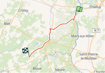
Randonnée Marche de 29 km à découvrir à Centre-Val de Loire, Cher, Apremont-sur-Allier. Cette randonnée est proposée par maginot.
Description
Départ de Gimouille ou ce rejoint L Allier et La Loire
Début long du canal sympa puis route jusqu’au beau Village d Apremont sur Allier
Puis après route longue en forêt puis long de canal chemin peu de passage et Refuge Nos Repos à Augy sur Aubois
Localisation
Pays :
France
Région :
Centre-Val de Loire
Département/Province :
Cher
Commune :
Apremont-sur-Allier
Localité :
Unknown
Départ:(Dec)
Départ:(UTM)
504195 ; 5196367 (31T) N.
Commentaires
Randonnées à proximité
![Randonnée Marche Cuffy - Gimouille - Photo](https://media.geolcdn.com/t/375/260/ext.jpg?maxdim=2&url=https%3A%2F%2Fstatic1.geolcdn.com%2Fsiteimages%2Fupload%2Ffiles%2F1553511878bg_sport_marche.png)
![Marche Marche](https://static1.geolcdn.com/sitytour/trail-icons/101.png)
Gimouille
Marche
Moyen
(1)
Cuffy,
Centre-Val de Loire,
Cher,
France
![](/images/other/stat-length.png)
8 km | 8,9 km-effort
1h 58min
![](https://static1.geolcdn.com/siteimages/upload/files/16400158638029165_repeat_loop_refresh_sync_direction_icon.png)
Oui
![Randonnée Vélo Cuffy - Loire à vélo 4 - Photo](https://media.geolcdn.com/t/375/260/ext.jpg?maxdim=2&url=https%3A%2F%2Fstatic1.geolcdn.com%2Fsiteimages%2Fupload%2Ffiles%2F1524743154velo.jpg)
![Vélo Vélo](https://static1.geolcdn.com/sitytour/trail-icons/200.png)
Loire à vélo 4
Vélo
Très facile
(1)
Cuffy,
Centre-Val de Loire,
Cher,
France
![](/images/other/stat-length.png)
14,8 km | 16,9 km-effort
1h 16min
![](https://static1.geolcdn.com/siteimages/upload/files/16400158638029165_repeat_loop_refresh_sync_direction_icon.png)
Non
![Randonnée Marche Gimouille - bec allier - Photo](https://media.geolcdn.com/t/375/260/ext.jpg?maxdim=2&url=https%3A%2F%2Fstatic1.geolcdn.com%2Fsiteimages%2Fupload%2Ffiles%2F1553511878bg_sport_marche.png)
![Marche Marche](https://static1.geolcdn.com/sitytour/trail-icons/101.png)
bec allier
Marche
Très facile
(2)
Gimouille,
Bourgogne-Franche-Comté,
Nièvre,
France
![](/images/other/stat-length.png)
8,2 km | 9,1 km-effort
2h 0min
![](https://static1.geolcdn.com/siteimages/upload/files/16400158638029165_repeat_loop_refresh_sync_direction_icon.png)
Oui
![Randonnée Marche Cuffy - la grenouille - Photo](https://media.geolcdn.com/t/375/260/ext.jpg?maxdim=2&url=https%3A%2F%2Fstatic1.geolcdn.com%2Fsiteimages%2Fupload%2Ffiles%2F1553511878bg_sport_marche.png)
![Marche Marche](https://static1.geolcdn.com/sitytour/trail-icons/101.png)
la grenouille
Marche
Très facile
(1)
Cuffy,
Centre-Val de Loire,
Cher,
France
![](/images/other/stat-length.png)
4,8 km | 5,4 km-effort
Inconnu
![](https://static1.geolcdn.com/siteimages/upload/files/16400158638029165_repeat_loop_refresh_sync_direction_icon.png)
Non
![Randonnée Marche Cuffy - Apremont Bec d'Allier - Photo](https://media.geolcdn.com/t/375/260/ext.jpg?maxdim=2&url=https%3A%2F%2Fstatic1.geolcdn.com%2Fsiteimages%2Fupload%2Ffiles%2F1553511878bg_sport_marche.png)
![Marche Marche](https://static1.geolcdn.com/sitytour/trail-icons/101.png)
Apremont Bec d'Allier
Marche
Difficile
Cuffy,
Centre-Val de Loire,
Cher,
France
![](/images/other/stat-length.png)
12,1 km | 13,1 km-effort
2h 58min
![](https://static1.geolcdn.com/siteimages/upload/files/16400158638029165_repeat_loop_refresh_sync_direction_icon.png)
Non
![Randonnée Marche Cuffy - Bec d'allier - Photo](https://media.geolcdn.com/t/375/260/ext.jpg?maxdim=2&url=https%3A%2F%2Fstatic1.geolcdn.com%2Fsiteimages%2Fupload%2Ffiles%2F1553511878bg_sport_marche.png)
![Marche Marche](https://static1.geolcdn.com/sitytour/trail-icons/101.png)
Bec d'allier
Marche
Moyen
Cuffy,
Centre-Val de Loire,
Cher,
France
![](/images/other/stat-length.png)
4,3 km | 4,5 km-effort
2h 30min
![](https://static1.geolcdn.com/siteimages/upload/files/16400158638029165_repeat_loop_refresh_sync_direction_icon.png)
Oui
![Randonnée Vélo Cuffy - nevers-cosne sur loire - Photo](https://media.geolcdn.com/t/375/260/ext.jpg?maxdim=2&url=https%3A%2F%2Fstatic1.geolcdn.com%2Fsiteimages%2Fupload%2Ffiles%2F1524743154velo.jpg)
![Vélo Vélo](https://static1.geolcdn.com/sitytour/trail-icons/200.png)
nevers-cosne sur loire
Vélo
Moyen
Cuffy,
Centre-Val de Loire,
Cher,
France
![](/images/other/stat-length.png)
64 km | 68 km-effort
Inconnu
![](https://static1.geolcdn.com/siteimages/upload/files/16400158638029165_repeat_loop_refresh_sync_direction_icon.png)
Non
![Randonnée Marche Gimouille - 2024 03 bec d'allier - Photo](https://media.geolcdn.com/t/375/260/ext.jpg?maxdim=2&url=https%3A%2F%2Fstatic1.geolcdn.com%2Fsiteimages%2Fupload%2Ffiles%2F1553511878bg_sport_marche.png)
![Marche Marche](https://static1.geolcdn.com/sitytour/trail-icons/101.png)
2024 03 bec d'allier
Marche
Facile
Gimouille,
Bourgogne-Franche-Comté,
Nièvre,
France
![](/images/other/stat-length.png)
4,8 km | 5,4 km-effort
1h 48min
![](https://static1.geolcdn.com/siteimages/upload/files/16400158638029165_repeat_loop_refresh_sync_direction_icon.png)
Non
![Randonnée Course à pied Gimouille - semi de Nevers - Photo](https://media.geolcdn.com/t/375/260/ext.jpg?maxdim=2&url=https%3A%2F%2Fstatic1.geolcdn.com%2Fsiteimages%2Fupload%2Ffiles%2F1524743154running.jpg)
![Course à pied Course à pied](https://static1.geolcdn.com/sitytour/trail-icons/103.png)
semi de Nevers
Course à pied
Très facile
Gimouille,
Bourgogne-Franche-Comté,
Nièvre,
France
![](/images/other/stat-length.png)
21 km | 23 km-effort
2h 11min
![](https://static1.geolcdn.com/siteimages/upload/files/16400158638029165_repeat_loop_refresh_sync_direction_icon.png)
Non