Randonnée Marche Emberménil - Embermenil (Boucles des Entonnoirs) 21 040m +252m - Photo

Embermenil (Boucles des Entonnoirs) 21 040m +252m

 DanielROLLET
DanielROLLET

Utilisateur

© OpenStreetMap contributors
Longueur
Longueur
21 km
Altitude max
Altitude max
304 m
Dénivelé positif
Dénivelé positif
254 m
Km-Effort
Km-Effort  
24 km
Altitude min
Altitude min
240 m
Dénivelé négatif
Dénivelé négatif
253 m
Boucle
Boucle
Oui
Date de création :
2021-10-24 07:09:28.485
Dernière modification :
2021-10-24 16:05:37.664

(0 Avis)

Marche
Marche
6h45
Difficulté : Difficile

Scannez ce code QR pour ouvrir la randonnée dans l'application SityTrail

Application GPS de randonnée GRATUITE

Logo SityTrail SityTrail

IGN / Instituts géographiques

Télécharger SityTrail sur l'App Store Télécharger SityTrail sur Google Play

Logo SityTrail SityTrail World

Le monde est à vous

Télécharger SityTrail sur l'App Store Télécharger SityTrail sur Google Play Télécharger SityTrail sur Huawei AppGallery

À propos

Randonnée Marche de 21 km à découvrir à Grand Est, Meurthe-et-Moselle, Emberménil. Cette randonnée est proposée par DanielROLLET.

Description

2021 10 24 Reco balisage avec Marie - 09h10 à 16h50
Grand beau temps (-2° le matin)

Profil altimétrique

Localisation

Pays :
France
Région :
Grand Est
Département/Province :
Meurthe-et-Moselle
Commune :
Emberménil
Localité :
Unknown
Départ:(UTM)
330198 ; 5388842 (32U) N.

Randonnées à proximité

Randonnée Marche Reillon - Reillon (Les Entonnoirs) - Photo
Marche
MMarie

Marche

Moyen
Reillon, Grand Est, Meurthe-et-Moselle, France
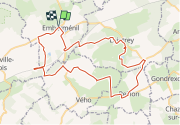
17,6 km | 21 km-effort
4h 27min
Oui
Randonnée Marche Reillon - Reillon, les Entonnoirs - Photo
Marche
reneperrin

Marche

Facile
Reillon, Grand Est, Meurthe-et-Moselle, France
8,1 km | 9,7 km-effort
1h 58min
Oui
Randonnée Marche Emberménil - Embermenil 6 470m +97m - Photo
Marche
DanielROLLET

Marche

Moyen
Emberménil, Grand Est, Meurthe-et-Moselle, France
6,5 km | 7,8 km-effort
1h 45min
Oui
Randonnée Marche Vaucourt - vaucourt - Photo
Marche
didier cornelius

Marche

Difficile
Vaucourt, Grand Est, Meurthe-et-Moselle, France
10 km | 12,1 km-effort
2h 2min
Oui
Randonnée Marche Emberménil - LES EVRIEUX - Photo
Marche
DanielROLLET

Marche

Facile
Emberménil, Grand Est, Meurthe-et-Moselle, France
6,5 km | 7,7 km-effort
2h 0min
Oui
Randonnée Marche Emberménil - Emberménil (Boucle Evrieux) 6 360m +96m - Photo
Marche
DanielROLLET

Marche

Moyen
Emberménil, Grand Est, Meurthe-et-Moselle, France
6,4 km | 7,6 km-effort
1h 44min
Oui
Randonnée Marche Emberménil - entonnoir veho - Photo
Marche
msylviotte

Marche

Moyen
Emberménil, Grand Est, Meurthe-et-Moselle, France
9,3 km | 11 km-effort
2h 3min
Oui
Randonnée Marche Emberménil - Emberménil (Les Boucles des Entonnoirs) 20 920m +253m - Photo
Marche
DanielROLLET

Marche

Moyen
Emberménil, Grand Est, Meurthe-et-Moselle, France
21 km | 24 km-effort
5h 30min
Oui
Randonnée Randonnée équestre Vého - yujhgk - Photo
Randonnée équestre
ACPL

Randonnée équestre

Très facile
Vého, Grand Est, Meurthe-et-Moselle, France
12,1 km | 13,9 km-effort
2h 2min
Oui


Fermer
Mes abonnements