Randonnée Marche Nohant-Vic - boucle noyant vic - Photo
 fab0202
fab0202

Utilisateur

© OpenStreetMap contributors
Longueur
Longueur
10,6 km
Altitude max
Altitude max
236 m
Dénivelé positif
Dénivelé positif
114 m
Km-Effort
Km-Effort  
12,1 km
Altitude min
Altitude min
181 m
Dénivelé négatif
Dénivelé négatif
113 m
Boucle
Boucle
Oui
Date de création :
2021-11-05 09:34:42.891
Dernière modification :
2021-11-05 12:10:15.563

(0 Avis)

Marche
Marche
2h20
Difficulté : Facile

Scannez ce code QR pour ouvrir la randonnée dans l'application SityTrail

Application GPS de randonnée GRATUITE

Logo SityTrail SityTrail

IGN / Instituts géographiques

Télécharger SityTrail sur l'App Store Télécharger SityTrail sur Google Play

Logo SityTrail SityTrail World

Le monde est à vous

Télécharger SityTrail sur l'App Store Télécharger SityTrail sur Google Play Télécharger SityTrail sur Huawei AppGallery

À propos

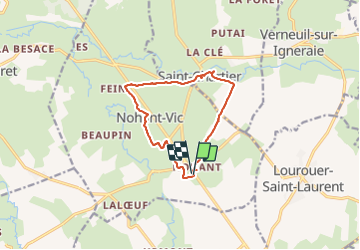
Randonnée Marche de 10,6 km à découvrir à Centre-Val de Loire, Indre, Nohant-Vic. Cette randonnée est proposée par fab0202.

Description

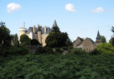
belle rando en boucle dans la campagne berrichonne avec vue sur eglise, chateau des romans de Geoges Sand. description sur de la rando sur site internet.

Profil altimétrique

Photos

Localisation

Pays :
France
Région :
Centre-Val de Loire
Département/Province :
Indre
Commune :
Nohant-Vic
Localité :
Unknown
Départ:(UTM)
421503 ; 5163947 (31T) N.

Randonnées à proximité

Randonnée Marche La Châtre - Sur les pas des Maîtres Sonneurs (La Châtre - La Berthenoux) - Photo
Marche
tracegps

Marche

Difficile
La Châtre, Centre-Val de Loire, Indre, France
18,5 km | 21 km-effort
4h 40min
Non
Randonnée Marche Saint-Chartier - Fôret de St Chartier - Photo
Marche
GUIDE
randotines

Marche

Facile
(1)
Saint-Chartier, Centre-Val de Loire, Indre, France
12,7 km | 15 km-effort
3h 17min
Oui
Randonnée A pied Lourouer-Saint-Laurent - Circuit pédestre n°34
A pied
fanthou

A pied

Facile
Lourouer-Saint-Laurent, Centre-Val de Loire, Indre, France
6,4 km | 7,1 km-effort
1h 36min
Oui
Randonnée A pied Montgivray - Circuit pédestre n°13
A pied
fanthou

A pied

Facile
Montgivray, Centre-Val de Loire, Indre, France
7,5 km | 8,5 km-effort
1h 55min
Oui
Randonnée A pied La Châtre - Entre Berry et Bourbonnais - Photo
A pied
zefreefly

A pied

Très difficile
La Châtre, Centre-Val de Loire, Indre, France
191 km | 227 km-effort
51h 33min
Oui
Randonnée Marche Nohant-Vic - Nohant - Photo
Marche
jlrayon

Marche

Facile
Nohant-Vic, Centre-Val de Loire, Indre, France
5,2 km | 5,9 km-effort
1h 20min
Oui
Randonnée Marche Sarzay - Étape 2 septembre 2023 - Photo
Marche
Pascal Bernaud

Marche

Très difficile
Sarzay, Centre-Val de Loire, Indre, France
23 km | 27 km-effort
9h 9min
Non
Randonnée Marche Saint-Chartier - 22 mai 22 - Photo
Marche
bruno124

Marche

Moyen
Saint-Chartier, Centre-Val de Loire, Indre, France
7,4 km | 8,1 km-effort
1h 17min
Oui
Randonnée Marche Nohant-Vic - petite boucle nohant - Photo
Marche
fab0202

Marche

Facile
Nohant-Vic, Centre-Val de Loire, Indre, France
3,7 km | 4 km-effort
55min
Oui


Fermer
Mes abonnements