Randonnée A pied Montgivray - Circuit pédestre n°13

Circuit pédestre n°13 "au fil de l'indre"

 fanthou
fanthou

Utilisateur

© OpenStreetMap contributors
Longueur
Longueur
7,5 km
Altitude max
Altitude max
237 m
Dénivelé positif
Dénivelé positif
72 m
Km-Effort
Km-Effort  
8,5 km
Altitude min
Altitude min
190 m
Dénivelé négatif
Dénivelé négatif
76 m
Boucle
Boucle
Oui
Date de création :
2023-09-26 08:41:35.142
Dernière modification :
2023-09-26 08:42:13.082

(0 Avis)

A pied
A pied
1h55
Difficulté : Facile

Scannez ce code QR pour ouvrir la randonnée dans l'application SityTrail

Application GPS de randonnée GRATUITE

Logo SityTrail SityTrail

IGN / Instituts géographiques

Télécharger SityTrail sur l'App Store Télécharger SityTrail sur Google Play

Logo SityTrail SityTrail World

Le monde est à vous

Télécharger SityTrail sur l'App Store Télécharger SityTrail sur Google Play Télécharger SityTrail sur Huawei AppGallery

À propos

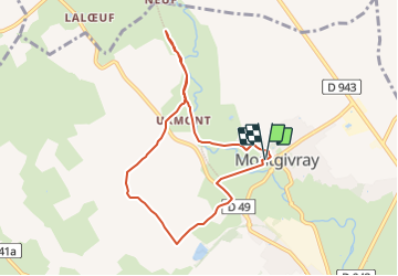
Randonnée A pied de 7,5 km à découvrir à Centre-Val de Loire, Indre, Montgivray. Cette randonnée est proposée par fanthou.

Description

Voici une campagne tranquille autour de Montgivray qui donne envie de marcher et de rêver, simplement. Plusieurs supports pour lire le circuit : En téléchargeant le PDF, sur l’application Cirkwi disponible sur Android et Iphone et bien sûr à l’office de tourisme du pays de George Sand à la Châtre. Départ : devant le camping de Montgivray

Profil altimétrique

Localisation

Pays :
France
Région :
Centre-Val de Loire
Département/Province :
Indre
Commune :
Montgivray
Localité :
Unknown
Départ:(Dec)
Départ:(UTM)
421759 ; 5161440 (31T) N.

Randonnées à proximité

Randonnée Marche La Châtre - Sur les pas des Maîtres Sonneurs (La Châtre - La Berthenoux) - Photo
Marche
tracegps

Marche

Difficile
La Châtre, Centre-Val de Loire, Indre, France
18,5 km | 21 km-effort
4h 40min
Non
Randonnée A pied Lourouer-Saint-Laurent - Circuit pédestre n°34
A pied
fanthou

A pied

Facile
Lourouer-Saint-Laurent, Centre-Val de Loire, Indre, France
6,4 km | 7,1 km-effort
1h 36min
Oui
Randonnée Marche Le Magny - Circuit pédestre n°10
Marche
fanthou

Marche

Facile
Le Magny, Centre-Val de Loire, Indre, France
6,2 km | 7,7 km-effort
1h 44min
Oui
Randonnée A pied La Châtre - Entre Berry et Bourbonnais - Photo
A pied
zefreefly

A pied

Très difficile
La Châtre, Centre-Val de Loire, Indre, France
191 km | 227 km-effort
51h 33min
Oui
Randonnée Marche Nohant-Vic - boucle noyant vic - Photo
Marche
fab0202

Marche

Facile
Nohant-Vic, Centre-Val de Loire, Indre, France
10,6 km | 12,1 km-effort
2h 20min
Oui
Randonnée Marche Nohant-Vic - Nohant - Photo
Marche
jlrayon

Marche

Facile
Nohant-Vic, Centre-Val de Loire, Indre, France
5,2 km | 5,9 km-effort
1h 20min
Oui
Randonnée Marche Sarzay - Étape 2 septembre 2023 - Photo
Marche
Pascal Bernaud

Marche

Très difficile
Sarzay, Centre-Val de Loire, Indre, France
23 km | 27 km-effort
9h 9min
Non
Randonnée Marche Saint-Chartier - 22 mai 22 - Photo
Marche
bruno124

Marche

Moyen
Saint-Chartier, Centre-Val de Loire, Indre, France
7,4 km | 8,1 km-effort
1h 17min
Oui
Randonnée Marche Nohant-Vic - petite boucle nohant - Photo
Marche
fab0202

Marche

Facile
Nohant-Vic, Centre-Val de Loire, Indre, France
3,7 km | 4 km-effort
55min
Oui


Fermer
Mes abonnements