Randonnée Cheval Lanuéjols - Boucle Chevauchée Cévenole MAJ nov2021 - Photo

Boucle Chevauchée Cévenole MAJ nov2021

 Lozère Cheval
Lozère Cheval

Utilisateur

© OpenStreetMap contributors
Longueur
Longueur
208 km
Altitude max
Altitude max
1699 m
Dénivelé positif
Dénivelé positif
5749 m
Km-Effort
Km-Effort  
285 km
Altitude min
Altitude min
503 m
Dénivelé négatif
Dénivelé négatif
5749 m
Boucle
Boucle
Oui
Date de création :
2021-11-14 07:34:59.255
Dernière modification :
2021-11-14 07:53:47.499

(0 Avis)

Cheval
Cheval
--
Difficulté : Très facile

Scannez ce code QR pour ouvrir la randonnée dans l'application SityTrail

Application GPS de randonnée GRATUITE

Logo SityTrail SityTrail

IGN / Instituts géographiques

Télécharger SityTrail sur l'App Store Télécharger SityTrail sur Google Play

Logo SityTrail SityTrail World

Le monde est à vous

Télécharger SityTrail sur l'App Store Télécharger SityTrail sur Google Play Télécharger SityTrail sur Huawei AppGallery

À propos

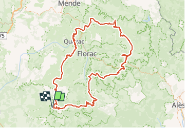
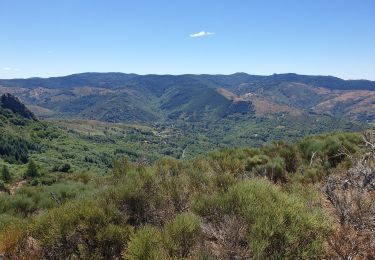
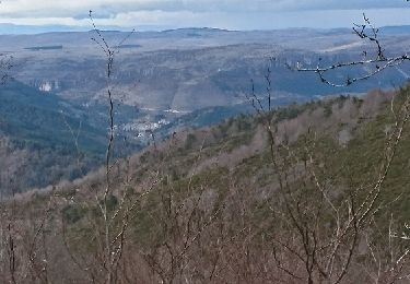
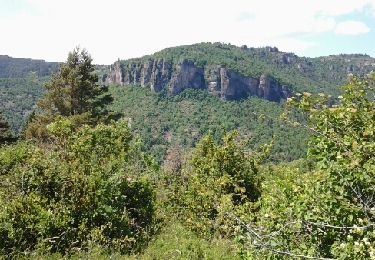
Randonnée Cheval de 208 km à découvrir à Occitanie, Gard, Lanuéjols. Cette randonnée est proposée par Lozère Cheval.

Description

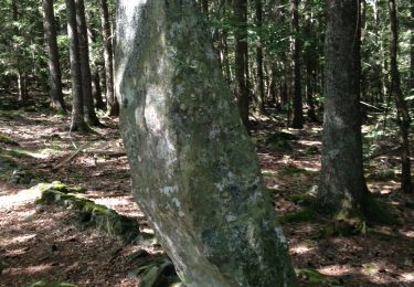
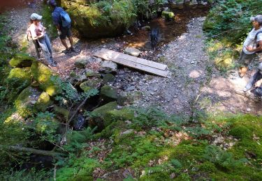
Modif suite au mail de Mossé 2020 et ferme des Mourènes 2021

Profil altimétrique

Points d'intérêt

Point d'intérêt Pont de Montvert - Sud Mont Lozère - Camping du Ventalon - Photo
Lozère Cheval
PONT DE MONTVERT - SUD MONT LOZÈRE 
Point d'intérêt Saint-André-de-Lancize - Ferme des Mourènes  - Photo
Lozère Cheval
SAINT-ANDRÉ-DE-LANCIZE 
Point d'intérêt Molezon - La Roquette G'Rando d'Anes - Photo
Lozère Cheval
Point d'intérêt Barre-des-Cévennes - Croisette Combes - Photo
Lozère Cheval
BARRE-DES-CÉVENNES 
Point d'intérêt Lanuéjols - Aiguebonne - Photo
Lozère Cheval
LANUÉJOLS 
Point d'intérêt Meyrueis - Ecurie Méjean - Photo
Lozère Cheval
MEYRUEIS 
Point d'intérêt Hures-la-Parade - Auberge Chanet  - Photo
Lozère Cheval
HURES-LA-PARADE 
Point d'intérêt Ispagnac - Anes du  Vigos  - Photo
Lozère Cheval
ISPAGNAC 
Point d'intérêt Ispagnac - Amatuzzi - Photo
Lozère Cheval
ISPAGNAC 
Point d'intérêt Ispagnac - Camping Cerisier - Photo
Lozère Cheval
Point d'intérêt Ispagnac - Hotel le Vallon  - Photo
Lozère Cheval
Point d'intérêt Saint-Étienne-du-Valdonnez - Auberge de Monmirat - Photo
Lozère Cheval
SAINT-ÉTIENNE-DU-VALDONNEZ 
Point d'intérêt Mont Lozère et Goulet - Hôtel le Refuge - Photo
Lozère Cheval
MONT LOZÈRE ET GOULET 
Point d'intérêt Vialas - Mas de la Barque - Photo
Lozère Cheval
Point d'intérêt Dourbies - Hotel du Parc l'Esperou - Photo
Lozère Cheval
Point d'intérêt Florac Trois Rivières - Camping Val Cévennes - Photo
Lozère Cheval
FLORAC TROIS RIVIÈRES 

Localisation

Pays :
France
Région :
Occitanie
Département/Province :
Gard
Commune :
Lanuéjols
Localité :
Unknown
Départ:(Dec)
Départ:(UTM)
532931 ; 4884776 (31T) N.

Randonnées à proximité

Randonnée Marche Trèves - st firmin - Photo
Marche
aldeu

Marche

Moyen
(1)
Trèves, Occitanie, Gard, France
6,9 km | 11,9 km-effort
2h 38min
Oui
Randonnée Marche Lanuéjols - Boucle Lanuejols - Pont de Claperousse - Photo
Marche
LBarel

Marche

Très facile
Lanuéjols, Occitanie, Gard, France
7,4 km | 9,2 km-effort
2h 0min
Oui
Randonnée Marche Lanuéjols - Commeiras - Photo
Marche
boudpn

Marche

Lanuéjols, Occitanie, Gard, France
16,3 km | 24 km-effort
6h 23min
Oui
Randonnée A pied Lanuéjols - 48 Gorges du Trevezel 11 06 17 - Photo
A pied
silvestreclaudine

A pied

Moyen
Lanuéjols, Occitanie, Gard, France
18,7 km | 30 km-effort
Inconnu
Oui
Randonnée Marche Trèves - trevezel in live - Photo
Marche
CASSISFRAMBOISE

Marche

Très difficile
Trèves, Occitanie, Gard, France
17,6 km | 30 km-effort
4h 51min
Oui
Randonnée A pied Saint-Sauveur-Camprieu - GR 66A - Photo
A pied
PRO

A pied

Facile
Saint-Sauveur-Camprieu, Occitanie, Gard, France
10,6 km | 14,3 km-effort
3h 14min
Non
Randonnée Marche Dourbies - Comeiras- Canayere  - Photo
Marche
gege30

Marche

Moyen
Dourbies, Occitanie, Gard, France
10,9 km | 15,6 km-effort
2h 34min
Oui
Randonnée Marche Meyrueis - la croix de fer  - Photo
Marche
Erickcausse

Marche

Moyen
Meyrueis, Occitanie, Lozère, France
18,8 km | 26 km-effort
3h 49min
Oui
Randonnée Marche Trèves - Treves gte st Firmin Comeiras - Photo
Marche
JEANJOSY

Marche

Moyen
Trèves, Occitanie, Gard, France
18,5 km | 31 km-effort
5h 41min
Oui


Fermer
Mes abonnements