Randonnée Marche Lièpvre - Liépvre - Roche des Fées, Roche de Chalmont, Rocher du Coucou, château du Frankenbourg - Photo

Liépvre - Roche des Fées, Roche de Chalmont, Rocher du Coucou, château du Frankenbourg

 Bart2015
Bart2015

Utilisateur

© OpenStreetMap contributors
Longueur
Longueur
19,4 km
Altitude max
Altitude max
860 m
Dénivelé positif
Dénivelé positif
897 m
Km-Effort
Km-Effort  
31 km
Altitude min
Altitude min
272 m
Dénivelé négatif
Dénivelé négatif
897 m
Boucle
Boucle
Oui
Date de création :
2022-01-02 08:24:21.5
Dernière modification :
2022-01-04 12:05:22.182

(0 Avis)

Marche
Marche
5h53
Difficulté : Difficile

Scannez ce code QR pour ouvrir la randonnée dans l'application SityTrail

Application GPS de randonnée GRATUITE

Logo SityTrail SityTrail

IGN / Instituts géographiques

Télécharger SityTrail sur l'App Store Télécharger SityTrail sur Google Play

Logo SityTrail SityTrail World

Le monde est à vous

Télécharger SityTrail sur l'App Store Télécharger SityTrail sur Google Play Télécharger SityTrail sur Huawei AppGallery

À propos

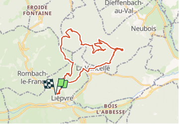
Randonnée Marche de 19,4 km à découvrir à Grand Est, Haut-Rhin, Lièpvre. Cette randonnée est proposée par Bart2015.

Description

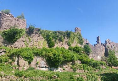
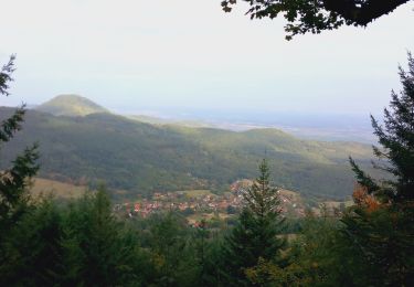
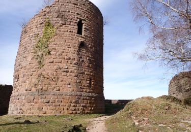
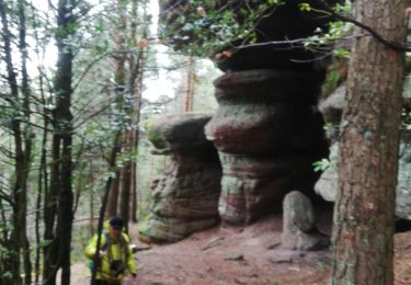
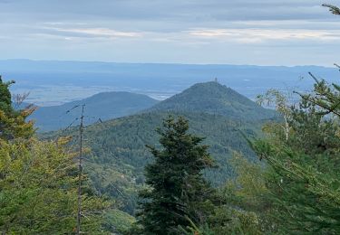
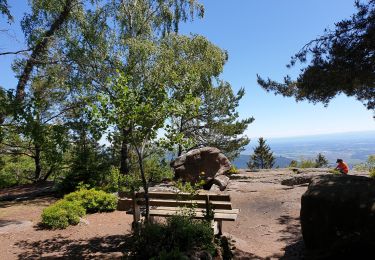
Randonnée physique sur la première partie jusqu'à la Roche de Chalmont. De magnifiques vues à Chalmont et au Rocher du Coucou où une halte s'impose. A moins que ce ne soit au Château du Frankenbourg. Le Château du Haut Koenigsbourg reste présent tout le long du circuit.
Bonne rando ...

Profil altimétrique

Photos

38 photos au total. Cliquez sur une photo pour les afficher toutes dans la galerie.

Localisation

Pays :
France
Région :
Grand Est
Département/Province :
Haut-Rhin
Commune :
Lièpvre
Localité :
Unknown
Départ:(UTM)
372300 ; 5348263 (32U) N.

Randonnées à proximité

Randonnée Marche La Vancelle - 2020-05-21 Marche La Vancelle Boucle - Photo
Marche
GUIDE
holtzv

Marche

Très facile
La Vancelle, Grand Est, Bas-Rhin, France
16,3 km | 26 km-effort
6h 41min
Oui
Randonnée Marche La Vancelle - 2015-01-02 Marche Rocher du Coucou Chateau Frankenbourg - Photo
Marche
GUIDE
holtzv

Marche

Facile
(1)
La Vancelle, Grand Est, Bas-Rhin, France
10,9 km | 18,1 km-effort
3h 47min
Oui
Randonnée V.T.T. Bergheim - 1 ère sortie - Photo
V.T.T.
Jeje Seuil

V.T.T.

Facile
Bergheim, Grand Est, Haut-Rhin, France
12,6 km | 19,1 km-effort
1h 53min
Oui
Randonnée Marche Breitenau - 20230309_rando_Breitenau_Rocher-du-Coucou_Chateau-du-Frankenbourg - Photo
Marche
nfranche

Marche

Moyen
Breitenau, Grand Est, Bas-Rhin, France
14,5 km | 24 km-effort
5h 24min
Oui
Randonnée Marche Rombach-le-Franc - Col de Fouchy  - Photo
Marche
apa

Marche

Moyen
Rombach-le-Franc, Grand Est, Haut-Rhin, France
11,8 km | 17,6 km-effort
3h 23min
Oui
Randonnée Marche Thannenkirch - Thannenkirch / rocher pointu / rocher des géants  - Photo
Marche
juliengsell

Marche

Difficile
(1)
Thannenkirch, Grand Est, Haut-Rhin, France
7,1 km | 13,4 km-effort
2h 8min
Oui
Randonnée Marche Thannenkirch - TAENCHEL CCA 200827 - Photo
Marche
Gatge

Marche

Très facile
Thannenkirch, Grand Est, Haut-Rhin, France
12,7 km | 18,7 km-effort
5h 2min
Oui
Randonnée Marche La Vancelle - Les Hauts de La Vancelle - Photo
Marche
VacheKiri67

Marche

Moyen
La Vancelle, Grand Est, Bas-Rhin, France
13,4 km | 21 km-effort
4h 39min
Oui
Randonnée Marche Breitenau - xc 191017 cv breitenau  - Photo
Marche
xc

Marche

Très facile
(1)
Breitenau, Grand Est, Bas-Rhin, France
11,9 km | 18,3 km-effort
5h 6min
Non


Fermer
Mes abonnements