Randonnée V.T.T. La Roque-Sainte-Marguerite - MILLAU2014-VEN-SP3 - Photo
 geraldboulic
geraldboulic

Utilisateur

© OpenStreetMap contributors
Longueur
Longueur
3,2 km
Altitude max
Altitude max
804 m
Dénivelé positif
Dénivelé positif
29 m
Km-Effort
Km-Effort  
4,3 km
Altitude min
Altitude min
577 m
Dénivelé négatif
Dénivelé négatif
242 m
Boucle
Boucle
Non
Date de création :
2014-12-10 00:00:00.0
Dernière modification :
2014-12-10 00:00:00.0

(0 Avis)

V.T.T.
V.T.T.
15m
Difficulté : Difficile

Scannez ce code QR pour ouvrir la randonnée dans l'application SityTrail

Application GPS de randonnée GRATUITE

Logo SityTrail SityTrail

IGN / Instituts géographiques

Télécharger SityTrail sur l'App Store Télécharger SityTrail sur Google Play

Logo SityTrail SityTrail World

Le monde est à vous

Télécharger SityTrail sur l'App Store Télécharger SityTrail sur Google Play Télécharger SityTrail sur Huawei AppGallery

À propos

Randonnée V.T.T. de 3,2 km à découvrir à Occitanie, Aveyron, La Roque-Sainte-Marguerite. Cette randonnée est proposée par geraldboulic.

Description

IDEM 2013

Profil altimétrique

Localisation

Pays :
France
Région :
Occitanie
Département/Province :
Aveyron
Commune :
La Roque-Sainte-Marguerite
Localité :
Unknown
Départ:(Dec)
Départ:(UTM)
523413 ; 4884645 (31T) N.

Randonnées à proximité

Randonnée Marche Revens - gardies, revens, gardies  - Photo
Marche
christo12

Marche

Moyen
(1)
Revens, Occitanie, Gard, France
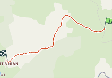
12,4 km | 20 km-effort
4h 26min
Oui
Randonnée Marche Saint-André-de-Vézines - site de roquesaltes - Photo
Marche
smoltmat65

Marche

Facile
Saint-André-de-Vézines, Occitanie, Aveyron, France
4,6 km | 6 km-effort
3h 4min
Non
Randonnée Marche Saint-André-de-Vézines - grotte pigeonnier de montmejean aller retour  - Photo
Marche
lablaquiere

Marche

Facile
Saint-André-de-Vézines, Occitanie, Aveyron, France
3,5 km | 5,3 km-effort
1h 30min
Oui
Randonnée Marche Revens - 2022 07-18 Revens Gard - Photo
Marche
josy31

Marche

Facile
Revens, Occitanie, Gard, France
10,4 km | 12,6 km-effort
2h 34min
Oui
Randonnée Marche Nant - Aveyron - St-Sauveur Pierrefiche-du-Larzac Montredon 23km 440m - Photo
Marche
RandoVal

Marche

Très facile
Nant, Occitanie, Aveyron, France
23 km | 29 km-effort
Inconnu
Oui
Randonnée Marche Saint-André-de-Vézines - Roquesaltes - Photo
Marche
alainandrejoly

Marche

Moyen
Saint-André-de-Vézines, Occitanie, Aveyron, France
17,5 km | 25 km-effort
5h 45min
Oui
Randonnée Marche La Roque-Sainte-Marguerite - LL34 Roques Altes - Corniche du Rajol - Photo
Marche
alainandrejoly

Marche

Moyen
La Roque-Sainte-Marguerite, Occitanie, Aveyron, France
23 km | 33 km-effort
7h 0min
Oui
Randonnée Marche Saint-André-de-Vézines - J3 2 Rochers de Roques Altès - Photo
Marche
ARPF

Marche

Facile
(1)
Saint-André-de-Vézines, Occitanie, Aveyron, France
5 km | 6,1 km-effort
2h 6min
Oui
Randonnée Marche Saint-André-de-Vézines -  Roques Altès 12 par St André de Vézines  - Photo
Marche
jeanneruols

Marche

Moyen
(1)
Saint-André-de-Vézines, Occitanie, Aveyron, France
15,1 km | 22 km-effort
5h 20min
Non


Fermer
Mes abonnements