Randonnée A pied Saint-Hubert - Chevaldot - Photo

Randonnées du CGT GUIDE+

© OpenStreetMap contributors
Longueur
Longueur
9 km
Altitude max
Altitude max
436 m
Dénivelé positif
Dénivelé positif
271 m
Km-Effort
Km-Effort  
12,6 km
Altitude min
Altitude min
248 m
Dénivelé négatif
Dénivelé négatif
272 m
Boucle
Boucle
Oui
Date de création :
2022-02-08 11:23:58.2
Dernière modification :
2022-02-21 10:05:15.0

(0 Avis)

A pied
A pied
2h52
Difficulté : Facile

Scannez ce code QR pour ouvrir la randonnée dans l'application SityTrail

Application GPS de randonnée GRATUITE

Logo SityTrail SityTrail

IGN / Instituts géographiques

Télécharger SityTrail sur l'App Store Télécharger SityTrail sur Google Play

Logo SityTrail SityTrail World

Le monde est à vous

Télécharger SityTrail sur l'App Store Télécharger SityTrail sur Google Play Télécharger SityTrail sur Huawei AppGallery

À propos

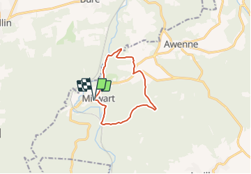
Randonnée A pied de 9 km à découvrir à Wallonie, Luxembourg, Saint-Hubert. Cette randonnée est proposée par Commissariat général au Tourisme.

Description

Randonnée créée par Forêt de Saint-Hubert.


Cette balade forestière, au départ de l'église de Mirwart vous mènera à Blanche Virée, point culminant du domaine provincial de Mirwart, à une altitude de 427m.


Site web: https://www.foretdesainthubert-tourisme.be/details/LOD-A0-005L-2PD4&type=8/

Profil altimétrique

Localisation

Pays :
Belgique
Région :
Wallonie
Département/Province :
Luxembourg
Commune :
Saint-Hubert
Localité :
Unknown
Départ:(UTM)
662026 ; 5547343 (31U) N.

Randonnées à proximité

Randonnée Marche Tellin - Tellin. Natura 2000, des sites qui valent le détour ! Lx 7 - Photo
Marche
GUIDE+

Marche

Moyen
(6)
Tellin, Wallonie, Luxembourg, Belgique
9,6 km | 11,9 km-effort
1h 30min
Oui
Randonnée Marche Saint-Hubert - Poix - Sainte-Adeline (SH15) - Photo
Marche
GUIDE+

Marche

Moyen
(7)
Saint-Hubert, Wallonie, Luxembourg, Belgique
8,3 km | 10,8 km-effort
2h 23min
Oui
Randonnée Marche Saint-Hubert - Mirwart_Vieux Moulin de Mirwart_Alternative Forêt (SH29 bis) - Photo
Marche
GUIDE+

Marche

Difficile
(11)
Saint-Hubert, Wallonie, Luxembourg, Belgique
10,8 km | 14,2 km-effort
3h 4min
Oui
Randonnée Marche Tellin - RL-GG-13_Grupont_Poix-Saint-Hubert - Photo
Marche
PRO

Marche

Très difficile
(2)
Tellin, Wallonie, Luxembourg, Belgique
26 km | 34 km-effort
7h 23min
Non
Randonnée Marche Tellin - Balade à Grupont - Photo
Marche
GUIDE
Desrumaux

Marche

Facile
(1)
Tellin, Wallonie, Luxembourg, Belgique
8,4 km | 11,9 km-effort
2h 33min
Oui
Randonnée Marche Tellin - Bure - Promenade des chapelles - Photo
Marche
GUIDE+

Marche

Facile
(1)
Tellin, Wallonie, Luxembourg, Belgique
4,5 km | 5,9 km-effort
1h 15min
Oui
Randonnée Marche Tellin - Tellin - Promenade du trou des Lûtons - Photo
Marche
GUIDE+

Marche

Facile
(1)
Tellin, Wallonie, Luxembourg, Belgique
5,2 km | 6,1 km-effort
1h 21min
Oui
Randonnée A pied Tellin - Tellin - Promenade des étangs - Photo
A pied
GUIDE+

A pied

Moyen
(2)
Tellin, Wallonie, Luxembourg, Belgique
20 km | 27 km-effort
Inconnu
Oui
Randonnée Marche Tellin - Grupont - Promenade du bois de Machi - Photo
Marche
GUIDE+

Marche

Moyen
(1)
Tellin, Wallonie, Luxembourg, Belgique
8,6 km | 12,6 km-effort
2h 37min
Oui


Fermer
Mes abonnements