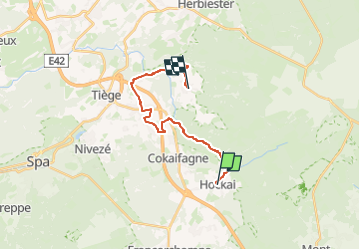
![](/images/other/stat-length.png)
![Randonnée Marche Stavelot - Chemin des Sources |étape n°4 HOCKAI – HOËGNE – SOLWASTER - Photo](https://media.geolcdn.com/t/1900/400/ext.pjpeg?maxdim=2&url=https%3A%2F%2Fmedia.geolcdn.com%2Ff%2Fb573e435-769d-4260-adb4-88571687d0e5.jpg)
Chemin des Sources |étape n°4 HOCKAI – HOËGNE – SOLWASTER
Chemin des Sources
Découvrez votre nature PRO
![Longueur](/images/other/stat-length.png)
![Altitude max](https://static1.geolcdn.com/siteimages/upload/files/1508320355ic_sort_altitude_max_24dp.png)
![Dénivelé positif](https://static1.geolcdn.com/siteimages/upload/files/1508320355ic_sort_den_pos_24dp.png)
![Km-Effort](/images/other/stat-length.png)
![Altitude min](https://static1.geolcdn.com/siteimages/upload/files/1508320355ic_sort_altitude_min_24dp.png)
![Dénivelé négatif](https://static1.geolcdn.com/siteimages/upload/files/1508320355ic_sort_den_neg_24dp.png)
![Boucle](https://static1.geolcdn.com/siteimages/upload/files/16400158638029165_repeat_loop_refresh_sync_direction_icon.png)
![Marche](https://static1.geolcdn.com/sitytour/trail-icons/101.png)
4h13
Difficulté : Difficile
![Scannez ce code QR pour ouvrir la randonnée dans l'application SityTrail](https://capi.geolives.com/qq0zvz2zws4bq2lad0pu/sitytour/trails/3081699/qr.png?size=200)
Application GPS de randonnée GRATUITE
À propos
Randonnée Marche de 15,1 km à découvrir à Wallonie, Liège, Stavelot. Cette randonnée est proposée par Chemin des Sources.
Description
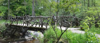
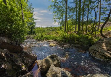
En quittant le petit village de Hockai par le pont du Centenaire, le Chemin des sources vous emmène dans la vallée de la Hoëgne, une des plus belles de la région en raison de ses nombreuses cascadelles. Cette descente sportive mais combien pittoresque sera facilitée par les aménagements (pontons, rambardes, caillebotis,) réalisés par une équipe de bénévoles passionnés.
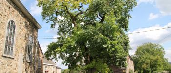
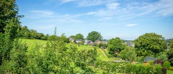
En prenant la direction du village de Sart, bien connu pour l’organisation de la fête typique des Vieux Métiers, vous distinguerez, à l’horizon, les terrils miniers de la région liégeoise. La balade se termine au village de Solwaster où subsistent de nombreuses maisons ardennaises en pierres du pays
Points d'intérêt
Localisation
Commentaires
Randonnées à proximité
![Randonnée Marche Malmedy - RB-Lg-31_Malmedy - Photo](https://media.geolcdn.com/t/375/260/ext.jpg?maxdim=2&url=https%3A%2F%2Fservices.sitytrail.com%2FGeolivesWS%2FDownloadMedia.ashx%3FTrailID%3D402114%26Media%3D216d2e53-3b66-4632-8b4d-0cea30889665.jpg)
![Marche Marche](https://static1.geolcdn.com/sitytour/trail-icons/101.png)
![Randonnée Marche Malmedy - Le trôs Maret - Photo](https://media.geolcdn.com/t/375/260/ext.jpg?maxdim=2&url=https%3A%2F%2Fmedia.geolcdn.com%2Ff%2F97b4be7b-87c1-46c9-b673-d6e164fd84f1.jpg)
![Marche Marche](https://static1.geolcdn.com/sitytour/trail-icons/101.png)
Marche
![](/images/other/stat-length.png)
![](https://static1.geolcdn.com/siteimages/upload/files/16400158638029165_repeat_loop_refresh_sync_direction_icon.png)
![Randonnée Marche Jalhay - RB-Lg-06_Solwaster_via-racc-1-et-3 - Photo](https://media.geolcdn.com/t/375/260/ext.jpg?maxdim=2&url=https%3A%2F%2Fservices.sitytrail.com%2FGeolivesWS%2FDownloadMedia.ashx%3FTrailID%3D209412%26Media%3Dcbaa668b-becb-4b36-acb0-64f56a1c97b3.jpg)
![Marche Marche](https://static1.geolcdn.com/sitytour/trail-icons/101.png)
Marche
![](/images/other/stat-length.png)
![](https://static1.geolcdn.com/siteimages/upload/files/16400158638029165_repeat_loop_refresh_sync_direction_icon.png)
![Randonnée Marche Jalhay - RB-Lg-06_Solwaster - Photo](https://media.geolcdn.com/t/375/260/ext.jpg?maxdim=2&url=https%3A%2F%2Fservices.sitytrail.com%2FGeolivesWS%2FDownloadMedia.ashx%3FTrailID%3D179564%26Media%3Dcbaa668b-becb-4b36-acb0-64f56a1c97b3.jpg)
![Marche Marche](https://static1.geolcdn.com/sitytour/trail-icons/101.png)
Marche
![](/images/other/stat-length.png)
![](https://static1.geolcdn.com/siteimages/upload/files/16400158638029165_repeat_loop_refresh_sync_direction_icon.png)
![Randonnée Marche Jalhay - Solwaster. Natura 2000, des sites qui valent le détour. Lg8 - Photo](https://media.geolcdn.com/t/375/260/ext.jpg?maxdim=2&url=https%3A%2F%2Fservices.sitytrail.com%2FGeolivesWS%2FDownloadMedia.ashx%3FTrailID%3D185776%26Media%3D07ec0791-d24b-4377-8f42-10c75b77cede.jpg)
![Marche Marche](https://static1.geolcdn.com/sitytour/trail-icons/101.png)
Marche
![](/images/other/stat-length.png)
![](https://static1.geolcdn.com/siteimages/upload/files/16400158638029165_repeat_loop_refresh_sync_direction_icon.png)
![Randonnée Marche Malmedy - La petite vallée sauvage du Trôs Marets - Photo](https://media.geolcdn.com/t/375/260/ext.jpg?maxdim=2&url=https%3A%2F%2Fstatic1.geolcdn.com%2Fsiteimages%2Fupload%2Ffiles%2F1553511878bg_sport_marche.png)
![Marche Marche](https://static1.geolcdn.com/sitytour/trail-icons/101.png)
Marche
![](/images/other/stat-length.png)
![](https://static1.geolcdn.com/siteimages/upload/files/16400158638029165_repeat_loop_refresh_sync_direction_icon.png)
![Randonnée Marche Jalhay - Pont de Belleheid à Spa par le GRP 573 - Photo](https://media.geolcdn.com/t/375/260/ext.jpg?maxdim=2&url=https%3A%2F%2Fmedia.geolcdn.com%2Ff%2F0d2f83e8-ec88-4180-940e-6c42b7bb9bcf.jpg)
![Marche Marche](https://static1.geolcdn.com/sitytour/trail-icons/101.png)
Marche
![](/images/other/stat-length.png)
![](https://static1.geolcdn.com/siteimages/upload/files/16400158638029165_repeat_loop_refresh_sync_direction_icon.png)
![Randonnée Marche Stavelot - 20211213 - Hockay 5.4 Km - Photo](https://media.geolcdn.com/t/375/260/ext.jpg?maxdim=2&url=https%3A%2F%2Fmedia.geolcdn.com%2Ff%2F2af4f064-4123-4bf2-a6f0-d07b2843bf6f.JPG)
![Marche Marche](https://static1.geolcdn.com/sitytour/trail-icons/101.png)
Marche
![](/images/other/stat-length.png)
![](https://static1.geolcdn.com/siteimages/upload/files/16400158638029165_repeat_loop_refresh_sync_direction_icon.png)
![Randonnée Marche Jalhay - Solwaster_Sawe_-_balade_56 - Photo](https://media.geolcdn.com/t/375/260/ext.jpg?maxdim=2&url=https%3A%2F%2Fmedia.geolcdn.com%2Ff%2F081cadfc-4766-4923-92bf-f568c48bec7d.jpg)
![Marche Marche](https://static1.geolcdn.com/sitytour/trail-icons/101.png)
Marche
![](/images/other/stat-length.png)
![](https://static1.geolcdn.com/siteimages/upload/files/16400158638029165_repeat_loop_refresh_sync_direction_icon.png)
Une magnifique randonnée majoritairement boisée le long de la Hoëgne et de la Sawe.