Randonnée A pied Heuvelland - Tweebergen wandelroute - Photo

Tous les sentiers balisés d’Europe PRO

© OpenStreetMap contributors
Longueur
Longueur
7,3 km
Altitude max
Altitude max
127 m
Dénivelé positif
Dénivelé positif
124 m
Km-Effort
Km-Effort  
9 km
Altitude min
Altitude min
34 m
Dénivelé négatif
Dénivelé négatif
123 m
Boucle
Boucle
Oui
Balise
Balise
Date de création :
2022-02-09 15:07:42.121
Dernière modification :
2022-02-09 17:54:02.796

(0 Avis)

A pied
A pied
2h02
Difficulté : Facile

Scannez ce code QR pour ouvrir la randonnée dans l'application SityTrail

Application GPS de randonnée GRATUITE

Logo SityTrail SityTrail

IGN / Instituts géographiques

Télécharger SityTrail sur l'App Store Télécharger SityTrail sur Google Play

Logo SityTrail SityTrail World

Le monde est à vous

Télécharger SityTrail sur l'App Store Télécharger SityTrail sur Google Play Télécharger SityTrail sur Huawei AppGallery

À propos

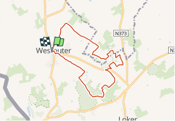
Randonnée A pied de 7,3 km à découvrir à Flandre, Flandre-Occidentale, Heuvelland. Cette randonnée est proposée par SityTrail - itinéraires balisés pédestres.

Description

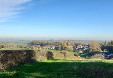
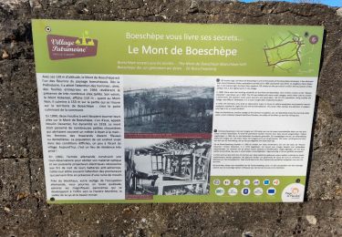
De Tweebergenwandelroute vertrekt vanuit de dorpskom van Westouter. Daarna wandel je naar de Sulferberg (88m) en het gelijknamige natuurreservaat. De toch gaat verder richting Rodeberg. Eenmaal boven wacht een avontuurlijke afdaling langs het Hellegat, een diep uitgesneden dal dat grotendeels bebost is. De terugweg leidt door het Kotje Piepersbos. Je wandelt terug naar

Photos

Localisation

Pays :
Belgique
Région :
Flandre
Département/Province :
Flandre-Occidentale
Commune :
Heuvelland
Localité :
Westoutre
Départ:(UTM)
482092 ; 5627372 (31U) N.

Randonnées à proximité

Randonnée Marche Heuvelland - Loker - Le Mont Rouge - Photo
Marche
tracegps

Marche

Moyen
(2)
Heuvelland, Flandre, Flandre-Occidentale, Belgique
8,7 km | 10,8 km-effort
2h 19min
Oui
Randonnée Marche Heuvelland - Westouter langs tweetermen - Photo
Marche
Wesley Samyn

Marche

Difficile
(1)
Heuvelland, Flandre, Flandre-Occidentale, Belgique
7,5 km | 9,1 km-effort
2h 4min
Oui
Randonnée Marche Saint-Jans-Cappel - sentier des jacynthes - Photo
Marche
Bernard.voyageur

Marche

Moyen
(1)
Saint-Jans-Cappel, Hauts-de-France, Nord, France
7,3 km | 9,2 km-effort
2h 1min
Oui
Randonnée Marche Bailleul - camping de la Ferme des Saules à côté de Bailleul, arrivée Deulemont - Photo
Marche
jeff2

Marche

Moyen
Bailleul, Hauts-de-France, Nord, France
32 km | 34 km-effort
9h 10min
Non
Randonnée Marche Heuvelland - Dranouter 12,3 km - Photo
Marche
GUIDE
rvapeldo

Marche

Facile
Heuvelland, Flandre, Flandre-Occidentale, Belgique
12,4 km | 14,5 km-effort
3h 32min
Oui
Randonnée Marche Heuvelland - Monts Rouge et Noir - Photo
Marche
Greg813

Marche

Difficile
Heuvelland, Flandre, Flandre-Occidentale, Belgique
24 km | 30 km-effort
5h 27min
Oui
Randonnée Marche Boeschepe - Boeschepe - Photo
Marche
fif59280

Marche

Difficile
Boeschepe, Hauts-de-France, Nord, France
10,6 km | 13 km-effort
2h 26min
Non
Randonnée A pied Poperinge - Zevekotepad Reningelst - Photo
A pied
PRO

A pied

Facile
Poperinge, Flandre, Flandre-Occidentale, Belgique
6,9 km | 7,9 km-effort
1h 47min
Oui
Randonnée Marche Heuvelland - Loker 18,2 km - Photo
Marche
GUIDE
rvapeldo

Marche

Moyen
Heuvelland, Flandre, Flandre-Occidentale, Belgique
18,3 km | 23 km-effort
5h 14min
Oui


Fermer
Mes abonnements