


13,2 km | 17,3 km-effort
![Randonnée A pied Aix-la-Chapelle - [B2] Rundweg Brander Feld - Photo](https://media.geolcdn.com/t/1900/400/ext.pjpeg?maxdim=2&url=https%3A%2F%2Fmedia.geolcdn.com%2Ff%2Fe83256ca-dc38-4ff1-a908-0baf40b53d68.jpeg)

Tous les sentiers balisés d’Europe PRO


Application GPS de randonnée GRATUITE
 SityTrail
IGN / Instituts géographiques
SityTrail World
Le monde est à vous
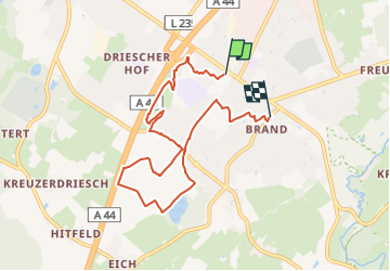
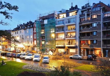
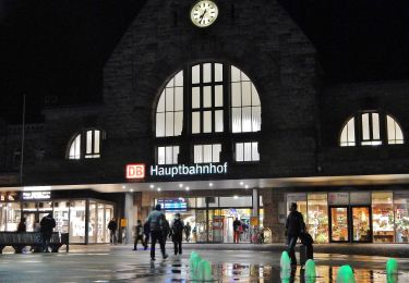
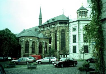
Randonnée A pied de 7,1 km à découvrir à Rhénanie-du-Nord-Westphalie, Région urbaine d'Aix-la-Chapelle, Aix-la-Chapelle. Cette randonnée est proposée par SityTrail - itinéraires balisés pédestres.
![Randonnée A pied Aix-la-Chapelle - [B2] Rundweg Brander Feld - Photo 1](https://media.geolcdn.com/t/2048/auto/a85443a3-4aa1-4909-9654-397fe51d0808.jpeg&format=jpg&maxdim=0 "Randonnée A pied Aix-la-Chapelle - [B2] Rundweg Brander Feld - Photo 1")
![Randonnée A pied Aix-la-Chapelle - [B2] Rundweg Brander Feld - Photo 2](https://media.geolcdn.com/t/2048/auto/e4d5ae9f-6c25-4164-9de1-aba48bc75705.jpeg&format=jpg&maxdim=0 "Randonnée A pied Aix-la-Chapelle - [B2] Rundweg Brander Feld - Photo 2")
![Randonnée A pied Aix-la-Chapelle - [B2] Rundweg Brander Feld - Photo 3](https://media.geolcdn.com/t/2048/auto/2c2ffa54-d748-4b89-a413-7752e21362b1.jpeg&format=jpg&maxdim=0 "Randonnée A pied Aix-la-Chapelle - [B2] Rundweg Brander Feld - Photo 3")
![Randonnée A pied Aix-la-Chapelle - [B2] Rundweg Brander Feld - Photo 4](https://media.geolcdn.com/t/2048/auto/01eb4052-860a-4b1c-8b68-b4660b62335d.jpeg&format=jpg&maxdim=0 "Randonnée A pied Aix-la-Chapelle - [B2] Rundweg Brander Feld - Photo 4")
![Randonnée A pied Aix-la-Chapelle - [B2] Rundweg Brander Feld - Photo 5](https://media.geolcdn.com/t/2048/auto/0f22044a-45a7-466c-8757-1e9f1e53dd23.jpeg&format=jpg&maxdim=0 "Randonnée A pied Aix-la-Chapelle - [B2] Rundweg Brander Feld - Photo 5")
![Randonnée A pied Aix-la-Chapelle - [B2] Rundweg Brander Feld - Photo 6](https://media.geolcdn.com/t/2048/auto/722b97be-cd40-4218-81d2-bb5c08543f84.jpeg&format=jpg&maxdim=0 "Randonnée A pied Aix-la-Chapelle - [B2] Rundweg Brander Feld - Photo 6")
![Randonnée A pied Aix-la-Chapelle - [B2] Rundweg Brander Feld - Photo 7](https://media.geolcdn.com/t/2048/auto/a2972e40-e1de-45e6-9ff3-9415ebb04421.jpeg&format=jpg&maxdim=0 "Randonnée A pied Aix-la-Chapelle - [B2] Rundweg Brander Feld - Photo 7")
![Randonnée A pied Aix-la-Chapelle - [B2] Rundweg Brander Feld - Photo 8](https://media.geolcdn.com/t/2048/auto/ef5e51eb-3037-4dd3-a1fc-636fd99428cc.jpeg&format=jpg&maxdim=0 "Randonnée A pied Aix-la-Chapelle - [B2] Rundweg Brander Feld - Photo 8")
![Randonnée A pied Aix-la-Chapelle - [B2] Rundweg Brander Feld - Photo 9](https://media.geolcdn.com/t/2048/auto/4e435327-84b5-4eee-aaea-53686f309add.jpeg&format=jpg&maxdim=0 "Randonnée A pied Aix-la-Chapelle - [B2] Rundweg Brander Feld - Photo 9")
![Randonnée A pied Aix-la-Chapelle - [B2] Rundweg Brander Feld - Photo 10](https://media.geolcdn.com/t/2048/auto/e83256ca-dc38-4ff1-a908-0baf40b53d68.jpeg&format=jpg&maxdim=0 "Randonnée A pied Aix-la-Chapelle - [B2] Rundweg Brander Feld - Photo 10")

Marche
Marche

Marche
Marche

A pied
A pied
A pied
A pied
A pied