![](/images/other/stat-length.png)
![Randonnée A pied Inconnu - Leineweberweg - Photo](https://media.geolcdn.com/t/1900/400/ext.pjpeg?maxdim=2&url=https%3A%2F%2Fmedia.geolcdn.com%2Ff%2F0bdf46a2-9d20-47ac-bb68-cffdb7dd2466.jpeg)
Leineweberweg
SityTrail - itinéraires balisés pédestres
Tous les sentiers balisés d’Europe PRO
![Longueur](/images/other/stat-length.png)
Longueur
6,9 km
![Altitude max](https://static1.geolcdn.com/siteimages/upload/files/1508320355ic_sort_altitude_max_24dp.png)
Altitude max
197 m
![Dénivelé positif](https://static1.geolcdn.com/siteimages/upload/files/1508320355ic_sort_den_pos_24dp.png)
Dénivelé positif
119 m
![Km-Effort](/images/other/stat-length.png)
Km-Effort
8,2 km
![Altitude min](https://static1.geolcdn.com/siteimages/upload/files/1508320355ic_sort_altitude_min_24dp.png)
Altitude min
85 m
![Dénivelé négatif](https://static1.geolcdn.com/siteimages/upload/files/1508320355ic_sort_den_neg_24dp.png)
Dénivelé négatif
49 m
![Boucle](https://static1.geolcdn.com/siteimages/upload/files/16400158638029165_repeat_loop_refresh_sync_direction_icon.png)
Boucle
Non
Balise
Date de création :
2022-02-11 16:00:00.99
Dernière modification :
2022-02-11 16:00:00.99
![A pied](https://static1.geolcdn.com/sitytour/trail-icons/100.png)
1h51
Difficulté : Facile
![Scannez ce code QR pour ouvrir la randonnée dans l'application SityTrail](https://capi.geolives.com/qq0zvz2zws4bq2lad0pu/sitytour/trails/3095584/qr.png?size=200)
Application GPS de randonnée GRATUITE
À propos
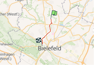
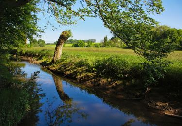
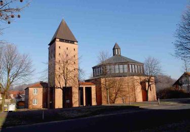
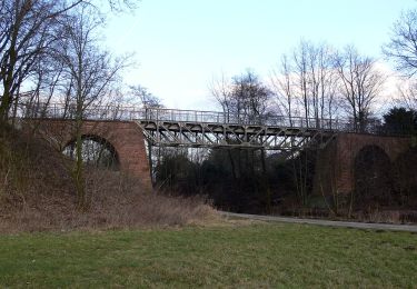
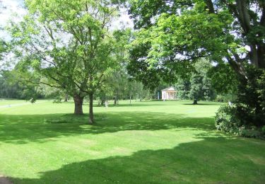
Randonnée A pied de 6,9 km à découvrir à Rhénanie-du-Nord-Westphalie, Bielefeld, Inconnu. Cette randonnée est proposée par SityTrail - itinéraires balisés pédestres.
Description
Randonnée créée par Teutoburger-Wald-Verein.
Site web: http://www.heimatverein-joellenbeck.de/joomla/index.php/menu-wanderwege/leineweberweg
Localisation
Pays :
Allemagne
Région :
Rhénanie-du-Nord-Westphalie
Département/Province :
Bielefeld
Commune :
Inconnu
Localité :
Jöllenbeck
Départ:(Dec)
Départ:(UTM)
468067 ; 5768598 (32U) N.
Commentaires
Randonnées à proximité
![Randonnée A pied Inconnu - Von Burg zu Berg - Photo](https://media.geolcdn.com/t/375/260/ext.jpg?maxdim=2&url=https%3A%2F%2Fmedia.geolcdn.com%2Ff%2Ffb5868bb-e2ef-464c-940e-562613eca188.jpeg)
![A pied A pied](https://static1.geolcdn.com/sitytour/trail-icons/100.png)
Von Burg zu Berg
A pied
Facile
Inconnu,
Rhénanie-du-Nord-Westphalie,
Bielefeld,
Allemagne
![](/images/other/stat-length.png)
4,4 km | 5,8 km-effort
1h 19min
![](https://static1.geolcdn.com/siteimages/upload/files/16400158638029165_repeat_loop_refresh_sync_direction_icon.png)
Non
![Randonnée A pied Inconnu - A4 - Jöllenbeck - Photo](https://media.geolcdn.com/t/375/260/ext.jpg?maxdim=2&url=https%3A%2F%2Fmedia.geolcdn.com%2Ff%2Fd456608d-1593-46a9-ba46-268f5f4b6c6d.jpeg)
![A pied A pied](https://static1.geolcdn.com/sitytour/trail-icons/100.png)
A4 - Jöllenbeck
A pied
Facile
Inconnu,
Rhénanie-du-Nord-Westphalie,
Bielefeld,
Allemagne
![](/images/other/stat-length.png)
5,6 km | 6,5 km-effort
1h 28min
![](https://static1.geolcdn.com/siteimages/upload/files/16400158638029165_repeat_loop_refresh_sync_direction_icon.png)
Oui
![Randonnée A pied Inconnu - A3 - Jöllenbeck - Photo](https://media.geolcdn.com/t/375/260/ext.jpg?maxdim=2&url=https%3A%2F%2Fmedia.geolcdn.com%2Ff%2F8a677e59-94dd-4e61-97cd-94b71f1244bf.jpeg)
![A pied A pied](https://static1.geolcdn.com/sitytour/trail-icons/100.png)
A3 - Jöllenbeck
A pied
Facile
Inconnu,
Rhénanie-du-Nord-Westphalie,
Bielefeld,
Allemagne
![](/images/other/stat-length.png)
9,6 km | 11,1 km-effort
2h 31min
![](https://static1.geolcdn.com/siteimages/upload/files/16400158638029165_repeat_loop_refresh_sync_direction_icon.png)
Oui
![Randonnée A pied Inconnu - Herfordweg - Photo](https://media.geolcdn.com/t/375/260/ext.jpg?maxdim=2&url=https%3A%2F%2Fmedia.geolcdn.com%2Ff%2Fd456608d-1593-46a9-ba46-268f5f4b6c6d.jpeg)
![A pied A pied](https://static1.geolcdn.com/sitytour/trail-icons/100.png)
Herfordweg
A pied
Facile
Inconnu,
Rhénanie-du-Nord-Westphalie,
Bielefeld,
Allemagne
![](/images/other/stat-length.png)
13,9 km | 15,7 km-effort
3h 33min
![](https://static1.geolcdn.com/siteimages/upload/files/16400158638029165_repeat_loop_refresh_sync_direction_icon.png)
Non
![Randonnée A pied Inconnu - A2 - Jöllenbeck - Photo](https://media.geolcdn.com/t/375/260/ext.jpg?maxdim=2&url=https%3A%2F%2Fmedia.geolcdn.com%2Ff%2Fd456608d-1593-46a9-ba46-268f5f4b6c6d.jpeg)
![A pied A pied](https://static1.geolcdn.com/sitytour/trail-icons/100.png)
A2 - Jöllenbeck
A pied
Facile
Inconnu,
Rhénanie-du-Nord-Westphalie,
Bielefeld,
Allemagne
![](/images/other/stat-length.png)
7,8 km | 9,3 km-effort
2h 7min
![](https://static1.geolcdn.com/siteimages/upload/files/16400158638029165_repeat_loop_refresh_sync_direction_icon.png)
Non
![Randonnée A pied Inconnu - A1 - Jöllenbeck - Photo](https://media.geolcdn.com/t/375/260/ext.jpg?maxdim=2&url=https%3A%2F%2Fmedia.geolcdn.com%2Ff%2F2c645367-cc01-41b4-a280-e4db94c2e3bd.jpeg)
![A pied A pied](https://static1.geolcdn.com/sitytour/trail-icons/100.png)
A1 - Jöllenbeck
A pied
Facile
Inconnu,
Rhénanie-du-Nord-Westphalie,
Bielefeld,
Allemagne
![](/images/other/stat-length.png)
5,5 km | 6,7 km-effort
1h 31min
![](https://static1.geolcdn.com/siteimages/upload/files/16400158638029165_repeat_loop_refresh_sync_direction_icon.png)
Non
![Randonnée A pied - Oberes Johannisbachtal - Photo](https://media.geolcdn.com/t/375/260/ext.jpg?maxdim=2&url=https%3A%2F%2Fmedia.geolcdn.com%2Ff%2Fc0655666-a8d0-4ea4-a6e9-acfdb1d6d0af.jpeg)
![A pied A pied](https://static1.geolcdn.com/sitytour/trail-icons/100.png)
Oberes Johannisbachtal
A pied
Facile
,
Rhénanie-du-Nord-Westphalie,
Bielefeld,
Allemagne
![](/images/other/stat-length.png)
5,6 km | 7,6 km-effort
1h 43min
![](https://static1.geolcdn.com/siteimages/upload/files/16400158638029165_repeat_loop_refresh_sync_direction_icon.png)
Non
![Randonnée A pied - Hügelland-Weg - Photo](https://media.geolcdn.com/t/375/260/ext.jpg?maxdim=2&url=https%3A%2F%2Fmedia.geolcdn.com%2Ff%2F0bdf46a2-9d20-47ac-bb68-cffdb7dd2466.jpeg)
![A pied A pied](https://static1.geolcdn.com/sitytour/trail-icons/100.png)
Hügelland-Weg
A pied
Facile
,
Rhénanie-du-Nord-Westphalie,
Bielefeld,
Allemagne
![](/images/other/stat-length.png)
16,7 km | 19,6 km-effort
4h 27min
![](https://static1.geolcdn.com/siteimages/upload/files/16400158638029165_repeat_loop_refresh_sync_direction_icon.png)
Non
![Randonnée A pied Inconnu - Dr.-Schmidt-Weg Bielefeld - Photo](https://media.geolcdn.com/t/375/260/ext.jpg?maxdim=2&url=https%3A%2F%2Fmedia.geolcdn.com%2Ff%2F1c3ee00e-34be-468f-95eb-1168da5cc0fb.jpeg)
![A pied A pied](https://static1.geolcdn.com/sitytour/trail-icons/100.png)
Dr.-Schmidt-Weg Bielefeld
A pied
Facile
Inconnu,
Rhénanie-du-Nord-Westphalie,
Bielefeld,
Allemagne
![](/images/other/stat-length.png)
3,7 km | 4 km-effort
54min
![](https://static1.geolcdn.com/siteimages/upload/files/16400158638029165_repeat_loop_refresh_sync_direction_icon.png)
Non