![](/images/other/stat-length.png)
![Randonnée A pied Wegberg - Rundweg A6 Papelter Bruch - Photo](https://media.geolcdn.com/t/1900/400/ext.pjpeg?maxdim=2&url=https%3A%2F%2Fmedia.geolcdn.com%2Ff%2F002dbc82-401e-4dbd-bc7a-52e6686ac285.jpeg)
Rundweg A6 Papelter Bruch
SityTrail - itinéraires balisés pédestres
Tous les sentiers balisés d’Europe PRO
![Longueur](/images/other/stat-length.png)
Longueur
8,7 km
![Altitude max](https://static1.geolcdn.com/siteimages/upload/files/1508320355ic_sort_altitude_max_24dp.png)
Altitude max
79 m
![Dénivelé positif](https://static1.geolcdn.com/siteimages/upload/files/1508320355ic_sort_den_pos_24dp.png)
Dénivelé positif
74 m
![Km-Effort](/images/other/stat-length.png)
Km-Effort
9,7 km
![Altitude min](https://static1.geolcdn.com/siteimages/upload/files/1508320355ic_sort_altitude_min_24dp.png)
Altitude min
52 m
![Dénivelé négatif](https://static1.geolcdn.com/siteimages/upload/files/1508320355ic_sort_den_neg_24dp.png)
Dénivelé négatif
77 m
![Boucle](https://static1.geolcdn.com/siteimages/upload/files/16400158638029165_repeat_loop_refresh_sync_direction_icon.png)
Boucle
Non
Balise
Date de création :
2022-02-11 16:01:24.752
Dernière modification :
2022-02-11 16:01:24.752
![A pied](https://static1.geolcdn.com/sitytour/trail-icons/100.png)
2h11
Difficulté : Facile
![Scannez ce code QR pour ouvrir la randonnée dans l'application SityTrail](https://capi.geolives.com/qq0zvz2zws4bq2lad0pu/sitytour/trails/3095632/qr.png?size=200)
Application GPS de randonnée GRATUITE
À propos
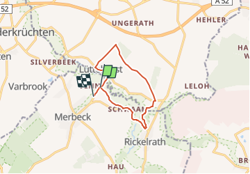
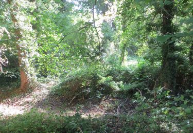
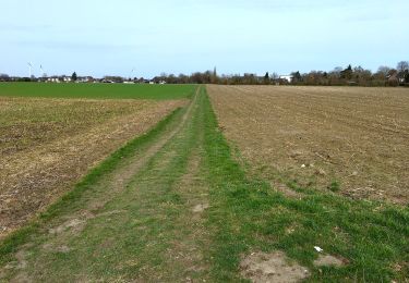
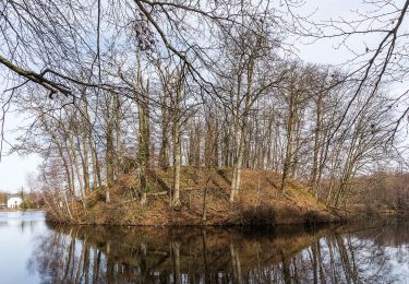
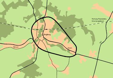
Randonnée A pied de 8,7 km à découvrir à Rhénanie-du-Nord-Westphalie, Kreis Heinsberg, Wegberg. Cette randonnée est proposée par SityTrail - itinéraires balisés pédestres.
Description
Randonnée créée par Naturpark Schwalm-Nette.
Symbole: Weißer Text A6 auf schwarzem Grund
Localisation
Pays :
Allemagne
Région :
Rhénanie-du-Nord-Westphalie
Département/Province :
Kreis Heinsberg
Commune :
Wegberg
Localité :
Unknown
Départ:(Dec)
Départ:(UTM)
308598 ; 5673717 (32U) N.
Commentaires
Randonnées à proximité
![Randonnée A pied Schwalmtal - Schwalmtalweg 2 - Photo](https://media.geolcdn.com/t/375/260/ext.jpg?maxdim=2&url=https%3A%2F%2Fmedia.geolcdn.com%2Ff%2F7fb43245-a4ee-4858-a1b8-6f2751526727.jpeg)
![A pied A pied](https://static1.geolcdn.com/sitytour/trail-icons/100.png)
Schwalmtalweg 2
A pied
Facile
Schwalmtal,
Rhénanie-du-Nord-Westphalie,
Kreis Viersen,
Allemagne
![](/images/other/stat-length.png)
8,8 km | 9,6 km-effort
2h 10min
![](https://static1.geolcdn.com/siteimages/upload/files/16400158638029165_repeat_loop_refresh_sync_direction_icon.png)
Oui
![Randonnée A pied Niederkrüchten - Rundweg](https://media.geolcdn.com/t/375/260/ext.jpg?maxdim=2&url=https%3A%2F%2Fmedia.geolcdn.com%2Ff%2Fc6cc8f66-e9e6-4f64-83c8-66841f4209ac.jpeg)
![A pied A pied](https://static1.geolcdn.com/sitytour/trail-icons/100.png)
Rundweg "A6 Ritzrode"
A pied
Facile
Niederkrüchten,
Rhénanie-du-Nord-Westphalie,
Kreis Viersen,
Allemagne
![](/images/other/stat-length.png)
9,8 km | 10,9 km-effort
2h 29min
![](https://static1.geolcdn.com/siteimages/upload/files/16400158638029165_repeat_loop_refresh_sync_direction_icon.png)
Oui
![Randonnée A pied Niederkrüchten - Rundweg A2 Raderwerkes Bruch - Photo](https://media.geolcdn.com/t/375/260/ext.jpg?maxdim=2&url=https%3A%2F%2Fmedia.geolcdn.com%2Ff%2F1bc52e79-4e1d-4591-93ac-0a74409ddd42.jpeg)
![A pied A pied](https://static1.geolcdn.com/sitytour/trail-icons/100.png)
Rundweg A2 Raderwerkes Bruch
A pied
Facile
Niederkrüchten,
Rhénanie-du-Nord-Westphalie,
Kreis Viersen,
Allemagne
![](/images/other/stat-length.png)
5,2 km | 5,8 km-effort
1h 19min
![](https://static1.geolcdn.com/siteimages/upload/files/16400158638029165_repeat_loop_refresh_sync_direction_icon.png)
Oui
![Randonnée A pied - Hardter Wald 2 - Photo](https://media.geolcdn.com/t/375/260/ext.jpg?maxdim=2&url=https%3A%2F%2Fmedia.geolcdn.com%2Ff%2Fa9802610-0130-469a-bc2d-a12bf3d08402.jpeg)
![A pied A pied](https://static1.geolcdn.com/sitytour/trail-icons/100.png)
Hardter Wald 2
A pied
Facile
,
Rhénanie-du-Nord-Westphalie,
Mönchengladbach,
Allemagne
![](/images/other/stat-length.png)
4,4 km | 4,8 km-effort
1h 5min
![](https://static1.geolcdn.com/siteimages/upload/files/16400158638029165_repeat_loop_refresh_sync_direction_icon.png)
Non
![Randonnée A pied Niederkrüchten - Rundweg A5 Hariksee - Photo](https://media.geolcdn.com/t/375/260/ext.jpg?maxdim=2&url=https%3A%2F%2Fmedia.geolcdn.com%2Ff%2F69bb452b-10e2-4575-b19a-5bd8b8dd4835.jpeg)
![A pied A pied](https://static1.geolcdn.com/sitytour/trail-icons/100.png)
Rundweg A5 Hariksee
A pied
Facile
Niederkrüchten,
Rhénanie-du-Nord-Westphalie,
Kreis Viersen,
Allemagne
![](/images/other/stat-length.png)
3,4 km | 3,8 km-effort
52min
![](https://static1.geolcdn.com/siteimages/upload/files/16400158638029165_repeat_loop_refresh_sync_direction_icon.png)
Oui
![Randonnée A pied Wegberg - Nordic Walking Park Wegberg Route Blau - Photo](https://media.geolcdn.com/t/375/260/ext.jpg?maxdim=2&url=https%3A%2F%2Fmedia.geolcdn.com%2Ff%2F4b1f9a0c-5ca6-4fb2-8afc-e66812732e5d.jpeg)
![A pied A pied](https://static1.geolcdn.com/sitytour/trail-icons/100.png)
Nordic Walking Park Wegberg Route Blau
A pied
Facile
Wegberg,
Rhénanie-du-Nord-Westphalie,
Kreis Heinsberg,
Allemagne
![](/images/other/stat-length.png)
10,2 km | 11,2 km-effort
2h 32min
![](https://static1.geolcdn.com/siteimages/upload/files/16400158638029165_repeat_loop_refresh_sync_direction_icon.png)
Oui
![Randonnée A pied Wegberg - Rundweg Beecker Wald A2 - Photo](https://media.geolcdn.com/t/375/260/ext.jpg?maxdim=2&url=https%3A%2F%2Fmedia.geolcdn.com%2Ff%2Fd9db701b-e7a2-4143-b264-985304917219.jpeg)
![A pied A pied](https://static1.geolcdn.com/sitytour/trail-icons/100.png)
Rundweg Beecker Wald A2
A pied
Facile
Wegberg,
Rhénanie-du-Nord-Westphalie,
Kreis Heinsberg,
Allemagne
![](/images/other/stat-length.png)
8,4 km | 9,3 km-effort
2h 7min
![](https://static1.geolcdn.com/siteimages/upload/files/16400158638029165_repeat_loop_refresh_sync_direction_icon.png)
Oui
![Randonnée A pied Wegberg - Rundweg A1 Arsbecker Meinweg - Photo](https://media.geolcdn.com/t/375/260/ext.jpg?maxdim=2&url=https%3A%2F%2Fmedia.geolcdn.com%2Ff%2F5acd597a-e981-42e3-b3b2-e9aaba32fd46.jpeg)
![A pied A pied](https://static1.geolcdn.com/sitytour/trail-icons/100.png)
Rundweg A1 Arsbecker Meinweg
A pied
Facile
Wegberg,
Rhénanie-du-Nord-Westphalie,
Kreis Heinsberg,
Allemagne
![](/images/other/stat-length.png)
6,3 km | 7 km-effort
1h 35min
![](https://static1.geolcdn.com/siteimages/upload/files/16400158638029165_repeat_loop_refresh_sync_direction_icon.png)
Non
![Randonnée A pied Wegberg - Rundweg A5 Lüttelforst - Photo](https://media.geolcdn.com/t/375/260/ext.jpg?maxdim=2&url=https%3A%2F%2Fmedia.geolcdn.com%2Ff%2F002dbc82-401e-4dbd-bc7a-52e6686ac285.jpeg)
![A pied A pied](https://static1.geolcdn.com/sitytour/trail-icons/100.png)
Rundweg A5 Lüttelforst
A pied
Facile
Wegberg,
Rhénanie-du-Nord-Westphalie,
Kreis Heinsberg,
Allemagne
![](/images/other/stat-length.png)
4,3 km | 4,7 km-effort
1h 3min
![](https://static1.geolcdn.com/siteimages/upload/files/16400158638029165_repeat_loop_refresh_sync_direction_icon.png)
Non