![](/images/other/stat-length.png)
![Randonnée A pied Unknown - Norrlandets kustled - Photo](https://media.geolcdn.com/t/1900/400/ext.pjpeg?maxdim=2&url=https%3A%2F%2Fmedia.geolcdn.com%2Ff%2F1ce7729c-36bb-457c-ade1-03249bcc6cee.jpeg)
Norrlandets kustled
SityTrail - itinéraires balisés pédestres
Tous les sentiers balisés d’Europe PRO
![Longueur](/images/other/stat-length.png)
![Altitude max](https://static1.geolcdn.com/siteimages/upload/files/1508320355ic_sort_altitude_max_24dp.png)
![Dénivelé positif](https://static1.geolcdn.com/siteimages/upload/files/1508320355ic_sort_den_pos_24dp.png)
![Km-Effort](/images/other/stat-length.png)
![Altitude min](https://static1.geolcdn.com/siteimages/upload/files/1508320355ic_sort_altitude_min_24dp.png)
![Dénivelé négatif](https://static1.geolcdn.com/siteimages/upload/files/1508320355ic_sort_den_neg_24dp.png)
![Boucle](https://static1.geolcdn.com/siteimages/upload/files/16400158638029165_repeat_loop_refresh_sync_direction_icon.png)
![A pied](https://static1.geolcdn.com/sitytour/trail-icons/100.png)
1h46
Difficulté : Facile
![Scannez ce code QR pour ouvrir la randonnée dans l'application SityTrail](https://capi.geolives.com/qq0zvz2zws4bq2lad0pu/sitytour/trails/3140796/qr.png?size=200)
Application GPS de randonnée GRATUITE
À propos
Randonnée A pied de 7,4 km à découvrir à Comté de Gävleborg. Cette randonnée est proposée par SityTrail - itinéraires balisés pédestres.
Description
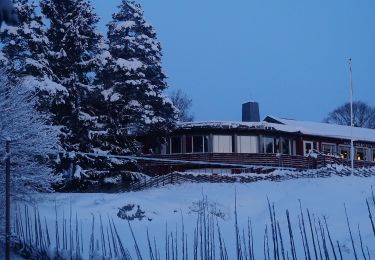
Norrlandets kustled är en vandringsled på ca 15 km som sträcker sig mellan Engeltofta och Marskärsudden, där du kan välja att gå hela eller delar av leden.
Site web: https://naturkartan.se/sv/naturkraftgastrikland/kustleden-engeltofta-bonan
Localisation
Commentaires
Randonnées à proximité
![Randonnée A pied Gävle - 15 km - Photo](https://media.geolcdn.com/t/375/260/ext.jpg?maxdim=2&url=https%3A%2F%2Fmedia.geolcdn.com%2Ff%2F098b77cf-dc61-4d0a-82fd-35508ce0b63d.jpeg)
![A pied A pied](https://static1.geolcdn.com/sitytour/trail-icons/100.png)
![Randonnée A pied Gävle - Motionsspår 2 - Photo](https://media.geolcdn.com/t/375/260/ext.jpg?maxdim=2&url=https%3A%2F%2Fmedia.geolcdn.com%2Ff%2F759e2ce4-bae1-435f-be21-2bfb9c231b7d.jpeg)
![A pied A pied](https://static1.geolcdn.com/sitytour/trail-icons/100.png)
A pied
![](/images/other/stat-length.png)
![](https://static1.geolcdn.com/siteimages/upload/files/16400158638029165_repeat_loop_refresh_sync_direction_icon.png)
![Randonnée A pied Gävle - Naturstig - Photo](https://media.geolcdn.com/t/375/260/ext.jpg?maxdim=2&url=https%3A%2F%2Fmedia.geolcdn.com%2Ff%2F098b77cf-dc61-4d0a-82fd-35508ce0b63d.jpeg)
![A pied A pied](https://static1.geolcdn.com/sitytour/trail-icons/100.png)
![Randonnée A pied Gävle - Milspåret - Photo](https://media.geolcdn.com/t/375/260/ext.jpg?maxdim=2&url=https%3A%2F%2Fmedia.geolcdn.com%2Ff%2Fa4170ef4-9818-4c75-a0b2-0d1e7313f32c.jpeg)
![A pied A pied](https://static1.geolcdn.com/sitytour/trail-icons/100.png)
A pied
![](/images/other/stat-length.png)
![](https://static1.geolcdn.com/siteimages/upload/files/16400158638029165_repeat_loop_refresh_sync_direction_icon.png)