Randonnée A pied Vaux-Saules - Vaux Saules Combe St Seine - Photo
 mricard
mricard

Utilisateur

© OpenStreetMap contributors
Longueur
Longueur
16,6 km
Altitude max
Altitude max
568 m
Dénivelé positif
Dénivelé positif
337 m
Km-Effort
Km-Effort  
21 km
Altitude min
Altitude min
403 m
Dénivelé négatif
Dénivelé négatif
335 m
Boucle
Boucle
Oui
Date de création :
2022-02-24 20:36:24.141
Dernière modification :
2022-02-26 19:25:58.316

(0 Avis)

A pied
A pied
4h00
Difficulté : Facile

Scannez ce code QR pour ouvrir la randonnée dans l'application SityTrail

Application GPS de randonnée GRATUITE

Logo SityTrail SityTrail

IGN / Instituts géographiques

Télécharger SityTrail sur l'App Store Télécharger SityTrail sur Google Play

Logo SityTrail SityTrail World

Le monde est à vous

Télécharger SityTrail sur l'App Store Télécharger SityTrail sur Google Play Télécharger SityTrail sur Huawei AppGallery

À propos

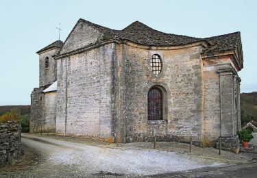
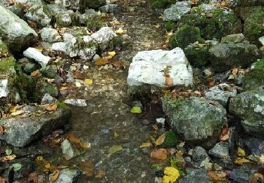
Randonnée A pied de 16,6 km à découvrir à Bourgogne-Franche-Comté, Côte-d'Or, Vaux-Saules. Cette randonnée est proposée par mricard.

Description

Une belle randonnée parcourant de larges chemins sur le plateau de St Seine. A l'abri des chasseurs. Très agréable sous un soleil hivernal. Pas de difficulté.

Profil altimétrique

Localisation

Pays :
France
Région :
Bourgogne-Franche-Comté
Département/Province :
Côte-d'Or
Commune :
Vaux-Saules
Localité :
Unknown
Départ:(UTM)
636091 ; 5258589 (31T) N.

Randonnées à proximité

Randonnée A pied Poncey-sur-l'Ignon - Sentier des Source de l'Ignon - Photo
A pied
PRO

A pied

Facile
Poncey-sur-l'Ignon, Bourgogne-Franche-Comté, Côte-d'Or, France
12,8 km | 16,4 km-effort
3h 44min
Oui
Randonnée Marche Saint-Martin-du-Mont - Cestres Francheville par Prairay - Photo
Marche
mricard

Marche

Moyen
Saint-Martin-du-Mont, Bourgogne-Franche-Comté, Côte-d'Or, France
17,4 km | 19,8 km-effort
3h 30min
Oui
Randonnée Marche Saint-Martin-du-Mont - 12_12_22 - Photo
Marche
baudon

Marche

Très difficile
Saint-Martin-du-Mont, Bourgogne-Franche-Comté, Côte-d'Or, France
48 km | 58 km-effort
7h 11min
Non
Randonnée Marche Saint-Martin-du-Mont - Saint Martin du mont Bordes Bricard Prairay - Photo
Marche
mricard

Marche

Difficile
Saint-Martin-du-Mont, Bourgogne-Franche-Comté, Côte-d'Or, France
17,3 km | 20 km-effort
4h 5min
Oui
Randonnée Marche Poncey-sur-l'Ignon - Les deux sources - Photo
Marche
lolomilastef

Marche

Difficile
Poncey-sur-l'Ignon, Bourgogne-Franche-Comté, Côte-d'Or, France
10,3 km | 12,9 km-effort
2h 56min
Oui
Randonnée Marche Champagny - Autour des sources du l'Ignon - Photo
Marche
yew

Marche

Facile
Champagny, Bourgogne-Franche-Comté, Côte-d'Or, France
9,9 km | 13,2 km-effort
2h 28min
Oui
Randonnée Marche Saint-Martin-du-Mont - sentier du bouton d'or - Photo
Marche
florianlive

Marche

Facile
Saint-Martin-du-Mont, Bourgogne-Franche-Comté, Côte-d'Or, France
21 km | 25 km-effort
4h 14min
Oui
Randonnée Marche Pellerey - 7_4_24 - Photo
Marche
baudon

Marche

Très difficile
Pellerey, Bourgogne-Franche-Comté, Côte-d'Or, France
21 km | 27 km-effort
8h 46min
Oui
Randonnée Marche Champagny - Champagny GR2 - Photo
Marche
mpstoop

Marche

Très difficile
Champagny, Bourgogne-Franche-Comté, Côte-d'Or, France
16,9 km | 22 km-effort
5h 2min
Non


Fermer
Mes abonnements