![](/images/other/stat-length.png)
![Randonnée Marche Dinant - Balade d'Anseremme à Walzin - Photo](https://media.geolcdn.com/t/1900/400/ext.pjpeg?maxdim=2&url=https%3A%2F%2Fmedia.geolcdn.com%2Ff%2F856a1eef-4c70-4b2c-8033-669caf1c750f.jpeg)
Balade d'Anseremme à Walzin
Desrumaux
Utilisateur GUIDE
![Longueur](/images/other/stat-length.png)
Longueur
9,8 km
![Altitude max](https://static1.geolcdn.com/siteimages/upload/files/1508320355ic_sort_altitude_max_24dp.png)
Altitude max
231 m
![Dénivelé positif](https://static1.geolcdn.com/siteimages/upload/files/1508320355ic_sort_den_pos_24dp.png)
Dénivelé positif
267 m
![Km-Effort](/images/other/stat-length.png)
Km-Effort
13,4 km
![Altitude min](https://static1.geolcdn.com/siteimages/upload/files/1508320355ic_sort_altitude_min_24dp.png)
Altitude min
93 m
![Dénivelé négatif](https://static1.geolcdn.com/siteimages/upload/files/1508320355ic_sort_den_neg_24dp.png)
Dénivelé négatif
268 m
![Boucle](https://static1.geolcdn.com/siteimages/upload/files/16400158638029165_repeat_loop_refresh_sync_direction_icon.png)
Boucle
Oui
Date de création :
2022-03-05 08:55:34.485
Dernière modification :
2022-03-08 08:31:53.633
![Marche](https://static1.geolcdn.com/sitytour/trail-icons/101.png)
4h15
Difficulté : Difficile
![Scannez ce code QR pour ouvrir la randonnée dans l'application SityTrail](https://capi.geolives.com/qq0zvz2zws4bq2lad0pu/sitytour/trails/3155530/qr.png?size=200)
Application GPS de randonnée GRATUITE
À propos
Randonnée Marche de 9,8 km à découvrir à Wallonie, Namur, Dinant. Cette randonnée est proposée par Desrumaux.
Description
Jolie balade un peu sportive au départ de l'église d'Anseremme vers le hameau de Walzin, la balade emprunte quelques sentiers escarpés, éviter les périodes humides.
Localisation
Pays :
Belgique
Région :
Wallonie
Département/Province :
Namur
Commune :
Dinant
Localité :
Unknown
Départ:(Dec)
Départ:(UTM)
636070 ; 5566858 (31U) N.
Commentaires
Randonnées à proximité
![Randonnée Marche Dinant - RB-Na-24_Anseremme - Photo](https://media.geolcdn.com/t/375/260/ext.jpg?maxdim=2&url=https%3A%2F%2Fmedia.geolcdn.com%2Ff%2F8f83e767-34d7-4d4c-9347-54379d263207.JPG)
![Marche Marche](https://static1.geolcdn.com/sitytour/trail-icons/101.png)
RB-Na-24_Anseremme
Marche
Très difficile
(14)
Dinant,
Wallonie,
Namur,
Belgique
![](/images/other/stat-length.png)
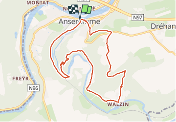
19,3 km | 26 km-effort
5h 57min
![](https://static1.geolcdn.com/siteimages/upload/files/16400158638029165_repeat_loop_refresh_sync_direction_icon.png)
Oui
![Randonnée Marche Houyet - RL-GG-20_Gendron_Dinant - Photo](https://media.geolcdn.com/t/375/260/ext.jpg?maxdim=2&url=https%3A%2F%2Fmedia.geolcdn.com%2Ff%2Fab939ff5-5b33-43fd-b036-e462abc33a68.jpg)
![Marche Marche](https://static1.geolcdn.com/sitytour/trail-icons/101.png)
RL-GG-20_Gendron_Dinant
Marche
Très difficile
(4)
Houyet,
Wallonie,
Namur,
Belgique
![](/images/other/stat-length.png)
23 km | 30 km-effort
6h 27min
![](https://static1.geolcdn.com/siteimages/upload/files/16400158638029165_repeat_loop_refresh_sync_direction_icon.png)
Non
![Randonnée Marche Onhaye - RB-Na-C2 La vallée du Flavion et le château moyenâgeux de Montaigle - complet - Photo](https://media.geolcdn.com/t/375/260/ext.jpg?maxdim=2&url=https%3A%2F%2Fmedia.geolcdn.com%2Ff%2Fb7ecc6ba-9854-4df0-a742-e28e7bd197a0.JPG)
![Marche Marche](https://static1.geolcdn.com/sitytour/trail-icons/101.png)
RB-Na-C2 La vallée du Flavion et le château moyenâgeux de Montaigle - complet
Marche
Très difficile
(2)
Onhaye,
Wallonie,
Namur,
Belgique
![](/images/other/stat-length.png)
20 km | 25 km-effort
5h 25min
![](https://static1.geolcdn.com/siteimages/upload/files/16400158638029165_repeat_loop_refresh_sync_direction_icon.png)
Oui
![Randonnée Marche Dinant - Balade à Dinant - La Réserve Naturelle de Moniat - Photo](https://media.geolcdn.com/t/375/260/ext.jpg?maxdim=2&url=https%3A%2F%2Fmedia.geolcdn.com%2Ff%2F765b9b62-b29c-4537-9ff6-9d29c15be9d8.jpg)
![Marche Marche](https://static1.geolcdn.com/sitytour/trail-icons/101.png)
Balade à Dinant - La Réserve Naturelle de Moniat
Marche
Très facile
(1)
Dinant,
Wallonie,
Namur,
Belgique
![](/images/other/stat-length.png)
8,4 km | 10,9 km-effort
3h 54min
![](https://static1.geolcdn.com/siteimages/upload/files/16400158638029165_repeat_loop_refresh_sync_direction_icon.png)
Oui
![Randonnée Marche Dinant - D'Anseremme à Dinant - Photo](https://media.geolcdn.com/t/375/260/ext.jpg?maxdim=2&url=https%3A%2F%2Fservices.sitytrail.com%2FGeolivesWS%2FDownloadMedia.ashx%3FTrailID%3D375788%26Media%3D9ffb86bd-da6e-4936-82b7-07dbdf349394.JPG)
![Marche Marche](https://static1.geolcdn.com/sitytour/trail-icons/101.png)
D'Anseremme à Dinant
Marche
Facile
(3)
Dinant,
Wallonie,
Namur,
Belgique
![](/images/other/stat-length.png)
8,3 km | 11,8 km-effort
2h 34min
![](https://static1.geolcdn.com/siteimages/upload/files/16400158638029165_repeat_loop_refresh_sync_direction_icon.png)
Oui
![Randonnée Marche Dinant - Balade à Bouvignes - Photo](https://media.geolcdn.com/t/375/260/ext.jpg?maxdim=2&url=https%3A%2F%2Fservices.sitytrail.com%2FGeolivesWS%2FDownloadMedia.ashx%3FTrailID%3D223072%26Media%3D8dae2923-6a84-4680-856b-d65e95092209.JPG)
![Marche Marche](https://static1.geolcdn.com/sitytour/trail-icons/101.png)
Balade à Bouvignes
Marche
Facile
(3)
Dinant,
Wallonie,
Namur,
Belgique
![](/images/other/stat-length.png)
4,8 km | 7,2 km-effort
1h 34min
![](https://static1.geolcdn.com/siteimages/upload/files/16400158638029165_repeat_loop_refresh_sync_direction_icon.png)
Oui
![Randonnée Marche Dinant - Balade en Réserve Naturelle de Devant Bouvignes - Photo](https://media.geolcdn.com/t/375/260/ext.jpg?maxdim=2&url=https%3A%2F%2Fservices.sitytrail.com%2FGeolivesWS%2FDownloadMedia.ashx%3FTrailID%3D222999%26Media%3D231bd4cd-9ad4-4a88-bcf6-84f0725ce446.JPG)
![Marche Marche](https://static1.geolcdn.com/sitytour/trail-icons/101.png)
Balade en Réserve Naturelle de Devant Bouvignes
Marche
Très facile
(3)
Dinant,
Wallonie,
Namur,
Belgique
![](/images/other/stat-length.png)
4,9 km | 6,9 km-effort
1h 32min
![](https://static1.geolcdn.com/siteimages/upload/files/16400158638029165_repeat_loop_refresh_sync_direction_icon.png)
Oui
![Randonnée Marche Dinant - Dinant: autour de la Citadelle. - Photo](https://media.geolcdn.com/t/375/260/ext.jpg?maxdim=2&url=https%3A%2F%2Fmedia.geolcdn.com%2Ff%2F0debd692-1141-41b3-8018-db8fdb788a39.jpg)
![Marche Marche](https://static1.geolcdn.com/sitytour/trail-icons/101.png)
Dinant: autour de la Citadelle.
Marche
Facile
(4)
Dinant,
Wallonie,
Namur,
Belgique
![](/images/other/stat-length.png)
5,7 km | 7,5 km-effort
1h 40min
![](https://static1.geolcdn.com/siteimages/upload/files/16400158638029165_repeat_loop_refresh_sync_direction_icon.png)
Oui
![Randonnée Marche Onhaye - RB-Na-C2 La vallée du Flavion et le château moyenâgeux de Montaigle - Raccourci - Photo](https://media.geolcdn.com/t/375/260/ext.jpg?maxdim=2&url=https%3A%2F%2Fmedia.geolcdn.com%2Ff%2Fea9d6b42-bd1e-414a-b13b-d67ccef864d3.JPG)
![Marche Marche](https://static1.geolcdn.com/sitytour/trail-icons/101.png)
RB-Na-C2 La vallée du Flavion et le château moyenâgeux de Montaigle - Raccourci
Marche
Difficile
(6)
Onhaye,
Wallonie,
Namur,
Belgique
![](/images/other/stat-length.png)
13 km | 16,2 km-effort
3h 29min
![](https://static1.geolcdn.com/siteimages/upload/files/16400158638029165_repeat_loop_refresh_sync_direction_icon.png)
Oui