Randonnée Marche Lannéanou - Tour de Lannéanou - Photo
 tracegps
tracegps

Utilisateur

© OpenStreetMap contributors
Longueur
Longueur
14,8 km
Altitude max
Altitude max
283 m
Dénivelé positif
Dénivelé positif
302 m
Km-Effort
Km-Effort  
18,8 km
Altitude min
Altitude min
187 m
Dénivelé négatif
Dénivelé négatif
295 m
Boucle
Boucle
Oui
Date de création :
2014-12-10 00:00:00.0
Dernière modification :
2014-12-10 00:00:00.0

(0 Avis)

Marche
Marche
3h40
Difficulté : Difficile

Scannez ce code QR pour ouvrir la randonnée dans l'application SityTrail

Application GPS de randonnée GRATUITE

Logo SityTrail SityTrail

IGN / Instituts géographiques

Télécharger SityTrail sur l'App Store Télécharger SityTrail sur Google Play

Logo SityTrail SityTrail World

Le monde est à vous

Télécharger SityTrail sur l'App Store Télécharger SityTrail sur Google Play Télécharger SityTrail sur Huawei AppGallery

À propos

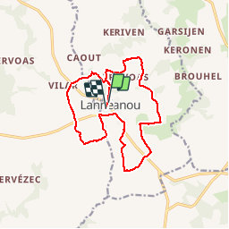
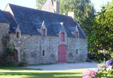
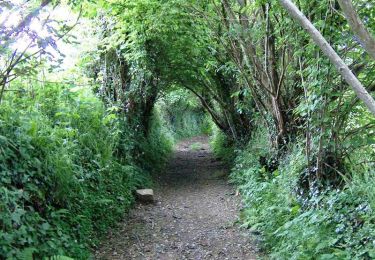
Randonnée Marche de 14,8 km à découvrir à Bretagne, Finistère, Lannéanou. Cette randonnée est proposée par tracegps.

Description

Circuit autour de Lannéanou. Vues sur les Monts d'Arrée, landes, bocages, chemin creux..... Une grande partie du circuit correspond à la rando "Sentier de Bleuniou Kaer" du topoguide PR "Le Pays de Morlaix à pied".

Profil altimétrique

Photos

Localisation

Pays :
France
Région :
Bretagne
Département/Province :
Finistère
Commune :
Lannéanou
Localité :
Unknown
Départ:(Dec)
Départ:(UTM)
450300 ; 5370928 (30U) N.

Randonnées à proximité

Randonnée Marche Plougonven - 1er septembre plougonven - Photo
Marche
mumusa29

Marche

Facile
Plougonven, Bretagne, Finistère, France
10,4 km | 12 km-effort
3h 53min
Oui
Randonnée Marche Botsorhel - Sentiers buissonniers à Botsorhel - Photo
Marche
tracegps

Marche

Difficile
(1)
Botsorhel, Bretagne, Finistère, France
14,2 km | 18,5 km-effort
4h 30min
Oui
Randonnée Marche Plougonven - Autour de Plougonven - Photo
Marche
tracegps

Marche

Facile
Plougonven, Bretagne, Finistère, France
4,1 km | 4,8 km-effort
1h 0min
Oui
Randonnée Marche Plougonven - Gaspern en Plougonven - Photo
Marche
tracegps

Marche

Moyen
Plougonven, Bretagne, Finistère, France
13,2 km | 16,1 km-effort
3h 30min
Oui
Randonnée V.T.T. Plougonven - Espace VTT-FFC Morlaix Monts d'Arrée, circuit n°9 de Plougonven - Photo
V.T.T.
tracegps

V.T.T.

Facile
(1)
Plougonven, Bretagne, Finistère, France
11,6 km | 14,4 km-effort
1h 0min
Oui
Randonnée Marche Plougonven - Espace VTT-FFC Morlaix Monts d'Arrée, circuit n°9 de Plougonven - Photo
Marche
tracegps

Marche

Moyen
Plougonven, Bretagne, Finistère, France
11,6 km | 14,4 km-effort
2h 0min
Oui
Randonnée Marche Botsorhel - 29_Botsorhel - Photo
Marche
jab31

Marche

Moyen
Botsorhel, Bretagne, Finistère, France
14,3 km | 18,6 km-effort
3h 22min
Oui
Randonnée A pied Botsorhel - Botshorel Morlaix - Photo
A pied
chessyca

A pied

Difficile
Botsorhel, Bretagne, Finistère, France
29 km | 35 km-effort
8h 3min
Non
Randonnée A pied Botsorhel - Etape 5 botsorhelx- morlaix - Photo
A pied
chessyca

A pied

Difficile
Botsorhel, Bretagne, Finistère, France
30 km | 36 km-effort
8h 10min
Non


Fermer
Mes abonnements