Randonnée V.T.T. Simorre - Du cours de la Lauze à Faget-Abatial - Photo

Du cours de la Lauze à Faget-Abatial

 tracegps
tracegps

Utilisateur

© OpenStreetMap contributors
Longueur
Longueur
18,5 km
Altitude max
Altitude max
312 m
Dénivelé positif
Dénivelé positif
383 m
Km-Effort
Km-Effort  
24 km
Altitude min
Altitude min
197 m
Dénivelé négatif
Dénivelé négatif
378 m
Boucle
Boucle
Oui
Date de création :
2014-12-10 00:00:00.0
Dernière modification :
2014-12-10 00:00:00.0

(0 Avis)

V.T.T.
V.T.T.
1h30
Difficulté : Moyen

Scannez ce code QR pour ouvrir la randonnée dans l'application SityTrail

Application GPS de randonnée GRATUITE

Logo SityTrail SityTrail

IGN / Instituts géographiques

Télécharger SityTrail sur l'App Store Télécharger SityTrail sur Google Play

Logo SityTrail SityTrail World

Le monde est à vous

Télécharger SityTrail sur l'App Store Télécharger SityTrail sur Google Play Télécharger SityTrail sur Huawei AppGallery

À propos

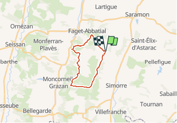
Randonnée V.T.T. de 18,5 km à découvrir à Occitanie, Gers, Simorre. Cette randonnée est proposée par tracegps.

Description

Magnifique parcours dans un secteur maintenant bien renseigné (je propose ici une variante courte) et balisé par le club de Simorre qui vient d'obtenir une base VTT officielle bien méritée. Merci à eux. A faire dans ce sens pour les vues sur les Pyrénées depuis les crêtes. Bons chemins bien entretenus, très peu de goudron.

Profil altimétrique

Photos

Localisation

Pays :
France
Région :
Occitanie
Département/Province :
Gers
Commune :
Simorre
Localité :
Unknown
Départ:(Dec)
Départ:(UTM)
315709 ; 4817202 (31T) N.

Randonnées à proximité

Randonnée Vélo Saramon - Circuit de 40 Km-  Saramon - Photo
Vélo
tracegps

Vélo

Moyen
Saramon, Occitanie, Gers, France
40 km | 47 km-effort
2h 0min
Oui
Randonnée Vélo Saramon - Circuit de 48 Km-  Saramon - Photo
Vélo
tracegps

Vélo

Difficile
Saramon, Occitanie, Gers, France
48 km | 57 km-effort
3h 0min
Oui
Randonnée Vélo Saramon - Circuit découverte 2 - Saramon - Photo
Vélo
tracegps

Vélo

Difficile
Saramon, Occitanie, Gers, France
50 km | 61 km-effort
3h 0min
Oui
Randonnée Vélo Saramon - Circuit découverte 1 - Saramon - Photo
Vélo
tracegps

Vélo

Facile
Saramon, Occitanie, Gers, France
29 km | 35 km-effort
1h 40min
Oui
Randonnée Vélo Saramon - Circuit découverte 3 - Saramon - Photo
Vélo
tracegps

Vélo

Facile
Saramon, Occitanie, Gers, France
28 km | 35 km-effort
1h 40min
Oui
Randonnée Vélo Saramon - Circuit de 44 Km-  Saramon - Photo
Vélo
tracegps

Vélo

Moyen
Saramon, Occitanie, Gers, France
44 km | 54 km-effort
2h 30min
Oui
Randonnée Marche Faget-Abbatial - 221205 Rando SLAT Hérechou - Photo
Marche
VIRGULIN

Marche

Facile
Faget-Abbatial, Occitanie, Gers, France
8,4 km | 10,8 km-effort
5h 22min
Oui
Randonnée Marche Saramon - saramon boulor lartigue - Photo
Marche
phb32220

Marche

Très facile
Saramon, Occitanie, Gers, France
15 km | 18,4 km-effort
2h 21min
Oui
Randonnée V.T.T. Simorre - Circuit des oiseaux - Simorre - Photo
V.T.T.
tracegps

V.T.T.

Très difficile
Simorre, Occitanie, Gers, France
52 km | 68 km-effort
5h 10min
Oui


Fermer
Mes abonnements