Randonnée V.T.T. Castella - Vers la fontaine de Fonbourrugues - Castella - Photo

Vers la fontaine de Fonbourrugues - Castella

 tracegps
tracegps

Utilisateur

© OpenStreetMap contributors
Longueur
Longueur
11,9 km
Altitude max
Altitude max
226 m
Dénivelé positif
Dénivelé positif
279 m
Km-Effort
Km-Effort  
15,6 km
Altitude min
Altitude min
109 m
Dénivelé négatif
Dénivelé négatif
280 m
Boucle
Boucle
Oui
Date de création :
2014-12-10 00:00:00.0
Dernière modification :
2014-12-10 00:00:00.0

(0 Avis)

V.T.T.
V.T.T.
1h30
Difficulté : Facile

Scannez ce code QR pour ouvrir la randonnée dans l'application SityTrail

Application GPS de randonnée GRATUITE

Logo SityTrail SityTrail

IGN / Instituts géographiques

Télécharger SityTrail sur l'App Store Télécharger SityTrail sur Google Play

Logo SityTrail SityTrail World

Le monde est à vous

Télécharger SityTrail sur l'App Store Télécharger SityTrail sur Google Play Télécharger SityTrail sur Huawei AppGallery

À propos

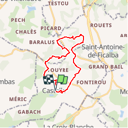
Randonnée V.T.T. de 11,9 km à découvrir à Nouvelle-Aquitaine, Lot-et-Garonne, Castella. Cette randonnée est proposée par tracegps.

Description

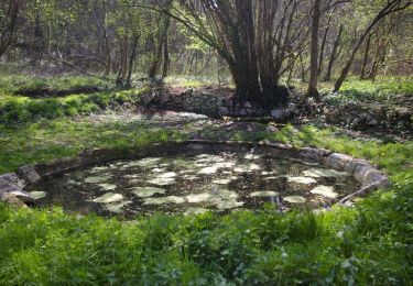
Sur le plateau entourant le bourg de Castella, les pistes sont larges. Après le franchissement de la petite vallée où coule le ruisseau de Fontirou, les chemins plus escarpés offrent ombrage et fraîcheur. Départ de la place de la mairie. Téléchargez la fiche de cette randonnée sur le site du Tourisme du Lot et Garonne.

Profil altimétrique

Photos

Localisation

Pays :
France
Région :
Nouvelle-Aquitaine
Département/Province :
Lot-et-Garonne
Commune :
Castella
Localité :
Unknown
Départ:(Dec)
Départ:(UTM)
315327 ; 4909256 (31T) N.

Randonnées à proximité

Randonnée Marche Pujols - Nouaillac, randonnée bucolique dans le Villeneuvois - Pays de la vallée du Lot - Photo
Marche
tracegps

Marche

Moyen
(1)
Pujols, Nouvelle-Aquitaine, Lot-et-Garonne, France
10,9 km | 15 km-effort
3h 0min
Oui
Randonnée A pied La Croix-Blanche - La Croix-Blanche, la balade du Bernou - 9,3km - Photo
A pied
PRO

A pied

Facile
La Croix-Blanche, Nouvelle-Aquitaine, Lot-et-Garonne, France
9,4 km | 11,4 km-effort
2h 34min
Oui
Randonnée A pied Saint-Antoine-de-Ficalba - Bonneval, le circuit des trois églises - 10,7km - Photo
A pied
PRO

A pied

Facile
Saint-Antoine-de-Ficalba, Nouvelle-Aquitaine, Lot-et-Garonne, France
10,9 km | 14,2 km-effort
3h 14min
Oui
Randonnée Cheval Castella - Vers la fontaine de Fonbourrugues - Castella - Photo
Cheval
tracegps

Cheval

Facile
Castella, Nouvelle-Aquitaine, Lot-et-Garonne, France
11,9 km | 15,6 km-effort
2h 0min
Oui
Randonnée Marche Castella - Vers la fontaine de Fonbourrugues - Castella - Photo
Marche
tracegps

Marche

Moyen
Castella, Nouvelle-Aquitaine, Lot-et-Garonne, France
11,9 km | 15,6 km-effort
3h 15min
Oui
Randonnée A pied Castella - Castella, randonnée vers le lac d ’Arasse et l’église de Sembas - 16,4km - Photo
A pied
PRO

A pied

Moyen
Castella, Nouvelle-Aquitaine, Lot-et-Garonne, France
16,3 km | 21 km-effort
4h 44min
Oui
Randonnée A pied Castella - Castella, vers la fontaine de Fonbourrugues - 12km - Photo
A pied
PRO

A pied

Facile
Castella, Nouvelle-Aquitaine, Lot-et-Garonne, France
11,9 km | 15,7 km-effort
3h 33min
Oui
Randonnée A pied Castella - Castella, la balade du Pech d’Ané - 6,3km - Photo
A pied
PRO

A pied

Facile
Castella, Nouvelle-Aquitaine, Lot-et-Garonne, France
6,3 km | 7,7 km-effort
1h 45min
Oui
Randonnée A pied Castella - Castella, la promenade de Mondou - 4,9km - Photo
A pied
PRO

A pied

Facile
Castella, Nouvelle-Aquitaine, Lot-et-Garonne, France
4,6 km | 6,1 km-effort
1h 22min
Oui


Fermer
Mes abonnements