![](/images/other/stat-length.png)
![Randonnée Marche Unknown - Midoum Rym beach. circuit découverte Giuseppe - Photo](https://media.geolcdn.com/t/1900/400/ext.pjpeg?maxdim=2&url=https%3A%2F%2Fmedia.geolcdn.com%2Ff%2Ff798a8fc-bd57-46ee-af75-8e55d4caa9b4.jpg)
Midoum Rym beach. circuit découverte Giuseppe
papiou
Utilisateur
![Longueur](/images/other/stat-length.png)
Longueur
8,3 km
![Altitude max](https://static1.geolcdn.com/siteimages/upload/files/1508320355ic_sort_altitude_max_24dp.png)
Altitude max
14 m
![Dénivelé positif](https://static1.geolcdn.com/siteimages/upload/files/1508320355ic_sort_den_pos_24dp.png)
Dénivelé positif
36 m
![Km-Effort](/images/other/stat-length.png)
Km-Effort
8,7 km
![Altitude min](https://static1.geolcdn.com/siteimages/upload/files/1508320355ic_sort_altitude_min_24dp.png)
Altitude min
-1 m
![Dénivelé négatif](https://static1.geolcdn.com/siteimages/upload/files/1508320355ic_sort_den_neg_24dp.png)
Dénivelé négatif
36 m
![Boucle](https://static1.geolcdn.com/siteimages/upload/files/16400158638029165_repeat_loop_refresh_sync_direction_icon.png)
Boucle
Oui
Date de création :
2022-03-29 08:33:54.684
Dernière modification :
2022-03-29 15:33:15.484
![Marche](https://static1.geolcdn.com/sitytour/trail-icons/101.png)
1h43
Difficulté : Facile
![Scannez ce code QR pour ouvrir la randonnée dans l'application SityTrail](https://capi.geolives.com/qq0zvz2zws4bq2lad0pu/sitytour/trails/3185189/qr.png?size=200)
Application GPS de randonnée GRATUITE
À propos
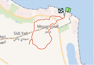
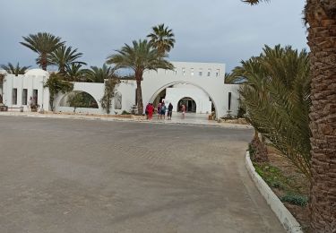
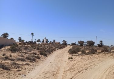
Randonnée Marche de 8,3 km à découvrir à Gouvernorat Médenine, Midoun. Cette randonnée est proposée par papiou.
Description
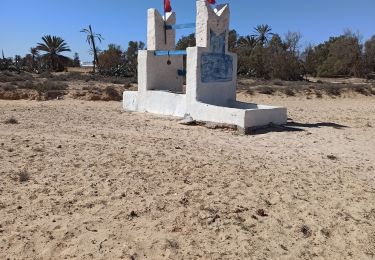
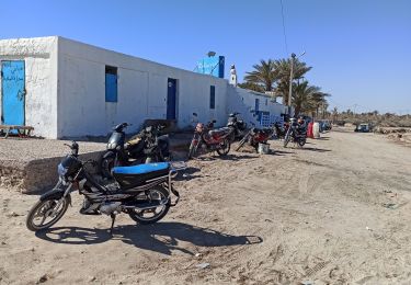
départ de L'hôtel partir vers la gauche et au rond point traverser les 2 toutes pour rentrer dans les terres. suivre ensuite l'appli
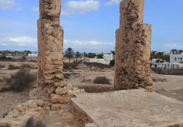
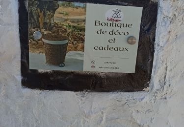
dans cette rando petit détour par l'atelier d'artisanat d'art. à voir absolument. très bon accueil
Localisation
Pays :
Tunisie
Région :
Gouvernorat Médenine
Département/Province :
Midoun
Commune :
Unknown
Localité :
Unknown
Départ:(Dec)
Départ:(UTM)
689386 ; 3744836 (32S) N.
Commentaires
Randonnées à proximité
![Randonnée Marche - circuit des puits. 10 km - Photo](https://media.geolcdn.com/t/375/260/ext.jpg?maxdim=2&url=https%3A%2F%2Fmedia.geolcdn.com%2Ff%2F1386a994-b987-41e0-ab44-d9ee3f26f5ce.jpg)
![Marche Marche](https://static1.geolcdn.com/sitytour/trail-icons/101.png)
circuit des puits. 10 km
Marche
Très facile
,
Gouvernorat Médenine,
Midoun,
Tunisie
![](/images/other/stat-length.png)
10 km | 10,7 km-effort
2h 20min
![](https://static1.geolcdn.com/siteimages/upload/files/16400158638029165_repeat_loop_refresh_sync_direction_icon.png)
Oui
![Randonnée Marche - l'île aux oiseaux par temps de lagune très basse - Photo](https://media.geolcdn.com/t/375/260/ext.jpg?maxdim=2&url=https%3A%2F%2Fmedia.geolcdn.com%2Ff%2F9d8b373a-508a-4615-b09b-565207cafe86.jpg)
![Marche Marche](https://static1.geolcdn.com/sitytour/trail-icons/101.png)
l'île aux oiseaux par temps de lagune très basse
Marche
Facile
,
Gouvernorat Médenine,
Midoun,
Tunisie
![](/images/other/stat-length.png)
9,2 km | 9,8 km-effort
2h 10min
![](https://static1.geolcdn.com/siteimages/upload/files/16400158638029165_repeat_loop_refresh_sync_direction_icon.png)
Oui
![Randonnée Marche - circuit des puits 10 km - Photo](https://media.geolcdn.com/t/375/260/ext.jpg?maxdim=2&url=https%3A%2F%2Fmedia.geolcdn.com%2Ff%2Fead715c0-f375-42db-9cad-88abaa66a947.jpg)
![Marche Marche](https://static1.geolcdn.com/sitytour/trail-icons/101.png)
circuit des puits 10 km
Marche
Facile
,
Gouvernorat Médenine,
Midoun,
Tunisie
![](/images/other/stat-length.png)
10 km | 10,7 km-effort
2h 30min
![](https://static1.geolcdn.com/siteimages/upload/files/16400158638029165_repeat_loop_refresh_sync_direction_icon.png)
Oui
![Randonnée Marche - Du Rym à l'île aux oiseaux par la lagune - Photo](https://media.geolcdn.com/t/375/260/ext.jpg?maxdim=2&url=https%3A%2F%2Fmedia.geolcdn.com%2Ff%2F08222ee4-c161-4138-a99e-e0b463f818fc.jpg)
![Marche Marche](https://static1.geolcdn.com/sitytour/trail-icons/101.png)
Du Rym à l'île aux oiseaux par la lagune
Marche
Très facile
,
Gouvernorat Médenine,
Midoun,
Tunisie
![](/images/other/stat-length.png)
10,8 km | 11,5 km-effort
2h 33min
![](https://static1.geolcdn.com/siteimages/upload/files/16400158638029165_repeat_loop_refresh_sync_direction_icon.png)
Oui
![Randonnée Marche - variante du Rym à la petite artisane puis retour par boulangerie - Photo](https://media.geolcdn.com/t/375/260/ext.jpg?maxdim=2&url=https%3A%2F%2Fmedia.geolcdn.com%2Ff%2F12b65f7d-a451-4659-be7a-4d60f1d227aa.jpg)
![Marche Marche](https://static1.geolcdn.com/sitytour/trail-icons/101.png)
variante du Rym à la petite artisane puis retour par boulangerie
Marche
Facile
,
Gouvernorat Médenine,
Midoun,
Tunisie
![](/images/other/stat-length.png)
9,4 km | 10 km-effort
2h 16min
![](https://static1.geolcdn.com/siteimages/upload/files/16400158638029165_repeat_loop_refresh_sync_direction_icon.png)
Oui
![Randonnée Marche - midoum seabel rym beach Hotel - Photo](https://media.geolcdn.com/t/375/260/ext.jpg?maxdim=2&url=https%3A%2F%2Fmedia.geolcdn.com%2Ff%2Fbbb4acf2-0c82-490c-a91f-e2a9a8ec312b.jpg)
![Marche Marche](https://static1.geolcdn.com/sitytour/trail-icons/101.png)
midoum seabel rym beach Hotel
Marche
Facile
,
Gouvernorat Médenine,
Midoun,
Tunisie
![](/images/other/stat-length.png)
10,5 km | 11,2 km-effort
2h 48min
![](https://static1.geolcdn.com/siteimages/upload/files/16400158638029165_repeat_loop_refresh_sync_direction_icon.png)
Oui
![Randonnée Marche - variante artisane facile - Photo](https://media.geolcdn.com/t/375/260/ext.jpg?maxdim=2&url=https%3A%2F%2Fmedia.geolcdn.com%2Ff%2F12d82cb7-21f9-440e-8a87-770f16f66d8f.jpg)
![Marche Marche](https://static1.geolcdn.com/sitytour/trail-icons/101.png)
variante artisane facile
Marche
Très facile
,
Gouvernorat Médenine,
Midoun,
Tunisie
![](/images/other/stat-length.png)
8,2 km | 8,7 km-effort
2h 1min
![](https://static1.geolcdn.com/siteimages/upload/files/16400158638029165_repeat_loop_refresh_sync_direction_icon.png)
Oui
![Randonnée Marche - circuit découverte de nouveaux sentiers autour du rym - Photo](https://media.geolcdn.com/t/375/260/ext.jpg?maxdim=2&url=https%3A%2F%2Fmedia.geolcdn.com%2Ff%2F6dd79abe-44e1-4594-a211-4dd3f3dae92c.jpg)
![Marche Marche](https://static1.geolcdn.com/sitytour/trail-icons/101.png)
circuit découverte de nouveaux sentiers autour du rym
Marche
Moyen
,
Gouvernorat Médenine,
Midoun,
Tunisie
![](/images/other/stat-length.png)
11,8 km | 12,5 km-effort
2h 29min
![](https://static1.geolcdn.com/siteimages/upload/files/16400158638029165_repeat_loop_refresh_sync_direction_icon.png)
Oui
![Randonnée Marche - variante du circuit de l'âne - Photo](https://media.geolcdn.com/t/375/260/ext.jpg?maxdim=2&url=https%3A%2F%2Fmedia.geolcdn.com%2Ff%2F3b63beed-8faf-4536-b581-6431aef36006.jpg)
![Marche Marche](https://static1.geolcdn.com/sitytour/trail-icons/101.png)
variante du circuit de l'âne
Marche
Facile
,
Gouvernorat Médenine,
Midoun,
Tunisie
![](/images/other/stat-length.png)
8,7 km | 9,5 km-effort
2h 7min
![](https://static1.geolcdn.com/siteimages/upload/files/16400158638029165_repeat_loop_refresh_sync_direction_icon.png)
Oui