![](/images/other/stat-length.png)
![Randonnée Marche Le Faouët - Le Faouët - Les cahots de l'Elle - Photo](https://media.geolcdn.com/t/1900/400/ext.pjpeg?maxdim=2&url=https%3A%2F%2Fmedia.geolcdn.com%2Ff%2F8161ed87-77e0-440e-83fe-42e4a2765925.jpg)
Le Faouët - Les cahots de l'Elle
MichelRando7656
Utilisateur
![Longueur](/images/other/stat-length.png)
Longueur
7,2 km
![Altitude max](https://static1.geolcdn.com/siteimages/upload/files/1508320355ic_sort_altitude_max_24dp.png)
Altitude max
174 m
![Dénivelé positif](https://static1.geolcdn.com/siteimages/upload/files/1508320355ic_sort_den_pos_24dp.png)
Dénivelé positif
155 m
![Km-Effort](/images/other/stat-length.png)
Km-Effort
9,3 km
![Altitude min](https://static1.geolcdn.com/siteimages/upload/files/1508320355ic_sort_altitude_min_24dp.png)
Altitude min
84 m
![Dénivelé négatif](https://static1.geolcdn.com/siteimages/upload/files/1508320355ic_sort_den_neg_24dp.png)
Dénivelé négatif
157 m
![Boucle](https://static1.geolcdn.com/siteimages/upload/files/16400158638029165_repeat_loop_refresh_sync_direction_icon.png)
Boucle
Oui
Date de création :
2022-04-16 11:44:38.318
Dernière modification :
2022-04-16 14:47:40.54
![Marche](https://static1.geolcdn.com/sitytour/trail-icons/101.png)
2h55
Difficulté : Moyen
![Scannez ce code QR pour ouvrir la randonnée dans l'application SityTrail](https://capi.geolives.com/qq0zvz2zws4bq2lad0pu/sitytour/trails/3206843/qr.png?size=200)
Application GPS de randonnée GRATUITE
À propos
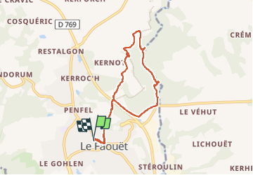
Randonnée Marche de 7,2 km à découvrir à Bretagne, Morbihan, Le Faouët. Cette randonnée est proposée par MichelRando7656.
Description
Un peu de goudron pour le début et la fin de la randonnée.
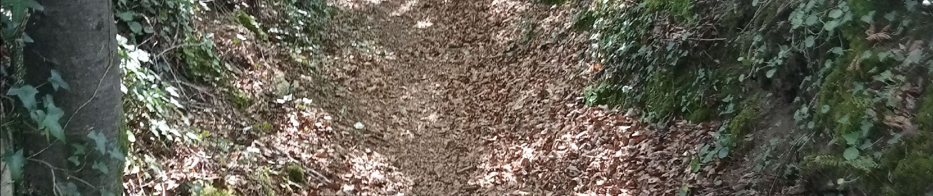
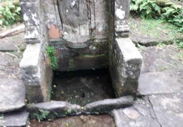
Entre les deux, de superbes sentiers encaissés et sous les grands arbres.
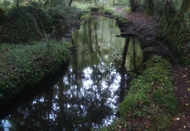
Une belle balade le long de l'Éllé , assez turbulente par un très beau soleil et une fraîcheur agréable sous les frondaisons.
Localisation
Pays :
France
Région :
Bretagne
Département/Province :
Morbihan
Commune :
Le Faouët
Localité :
Unknown
Départ:(Dec)
Départ:(UTM)
463298 ; 5320179 (30U) N.
Commentaires
Randonnées à proximité
![Randonnée Marche Lanvénégen - Lanvenegen - Photo](https://media.geolcdn.com/t/375/260/ext.jpg?maxdim=2&url=https%3A%2F%2Fmedia.geolcdn.com%2Ff%2F4fe6c41f-566e-4b7f-b4ae-6e93ef3bc7f5.jpg)
![Marche Marche](https://static1.geolcdn.com/sitytour/trail-icons/101.png)
Lanvenegen
Marche
Difficile
Lanvénégen,
Bretagne,
Morbihan,
France
![](/images/other/stat-length.png)
10,5 km | 13 km-effort
3h 9min
![](https://static1.geolcdn.com/siteimages/upload/files/16400158638029165_repeat_loop_refresh_sync_direction_icon.png)
Oui
![Randonnée Marche Le Faouët - Sainte Barbe - Le Faouet 56 - Photo](https://media.geolcdn.com/t/375/260/ext.jpg?maxdim=2&url=https%3A%2F%2Fmedia.geolcdn.com%2Ff%2F1a4a9347-1614-431d-9347-635895bd324e.jpg)
![Marche Marche](https://static1.geolcdn.com/sitytour/trail-icons/101.png)
Sainte Barbe - Le Faouet 56
Marche
Moyen
Le Faouët,
Bretagne,
Morbihan,
France
![](/images/other/stat-length.png)
4,6 km | 6,1 km-effort
2h 20min
![](https://static1.geolcdn.com/siteimages/upload/files/16400158638029165_repeat_loop_refresh_sync_direction_icon.png)
Non
![Randonnée Marche Le Faouët - Tour des Chapelles au Faouët (56) - Photo](https://media.geolcdn.com/t/375/260/ext.jpg?maxdim=2&url=https%3A%2F%2Fmedia.geolcdn.com%2Ff%2F569af394-e8cb-48c9-a941-179cfca2fe18.jpg)
![Marche Marche](https://static1.geolcdn.com/sitytour/trail-icons/101.png)
Tour des Chapelles au Faouët (56)
Marche
Facile
Le Faouët,
Bretagne,
Morbihan,
France
![](/images/other/stat-length.png)
13,4 km | 16,6 km-effort
4h 23min
![](https://static1.geolcdn.com/siteimages/upload/files/16400158638029165_repeat_loop_refresh_sync_direction_icon.png)
Oui
![Randonnée Marche Le Faouët - Le FAOUËT / LANVENEGEN - Photo](https://media.geolcdn.com/t/375/260/ext.jpg?maxdim=2&url=https%3A%2F%2Fmedia.geolcdn.com%2Ff%2F1977e69c-d0e8-4cb6-a2fa-715e82acb2c0.jpg)
![Marche Marche](https://static1.geolcdn.com/sitytour/trail-icons/101.png)
Le FAOUËT / LANVENEGEN
Marche
Moyen
Le Faouët,
Bretagne,
Morbihan,
France
![](/images/other/stat-length.png)
24 km | 30 km-effort
6h 24min
![](https://static1.geolcdn.com/siteimages/upload/files/16400158638029165_repeat_loop_refresh_sync_direction_icon.png)
Oui
![Randonnée Marche Lanvénégen - LANVENEGEN - Photo](https://media.geolcdn.com/t/375/260/ext.jpg?maxdim=2&url=https%3A%2F%2Fservices.sitytrail.com%2FGeolivesWS%2FDownloadMedia.ashx%3FTrailID%3D980777%26Media%3Dfix__20180603164615.jpg)
![Marche Marche](https://static1.geolcdn.com/sitytour/trail-icons/101.png)
![Randonnée Marche Le Faouët - le_faouet - Photo](https://media.geolcdn.com/t/375/260/ext.jpg?maxdim=2&url=https%3A%2F%2Fstatic1.geolcdn.com%2Fsiteimages%2Fupload%2Ffiles%2F1553511878bg_sport_marche.png)
![Marche Marche](https://static1.geolcdn.com/sitytour/trail-icons/101.png)
le_faouet
Marche
Très facile
Le Faouët,
Bretagne,
Morbihan,
France
![](/images/other/stat-length.png)
8,8 km | 10,7 km-effort
2h 34min
![](https://static1.geolcdn.com/siteimages/upload/files/16400158638029165_repeat_loop_refresh_sync_direction_icon.png)
Non
![Randonnée Marche Le Faouët - circuit de saint jean - Photo](https://media.geolcdn.com/t/375/260/ext.jpg?maxdim=2&url=https%3A%2F%2Fstatic1.geolcdn.com%2Fsiteimages%2Fupload%2Ffiles%2F1553511878bg_sport_marche.png)
![Marche Marche](https://static1.geolcdn.com/sitytour/trail-icons/101.png)
circuit de saint jean
Marche
Facile
Le Faouët,
Bretagne,
Morbihan,
France
![](/images/other/stat-length.png)
5,5 km | 6,7 km-effort
1h 35min
![](https://static1.geolcdn.com/siteimages/upload/files/16400158638029165_repeat_loop_refresh_sync_direction_icon.png)
Oui
![Randonnée sport Le Faouët - 2023-04-13_21h02m39_SityTrail - 3586579 - chaos-et-chapelle-x-le-faouet - Photo](https://media.geolcdn.com/t/375/260/ext.jpg?maxdim=2&url=https%3A%2F%2Fsecurestorage.geolives.com%2Fsitytour%2Ftrail-bg%2Fdefault.jpg)
2023-04-13_21h02m39_SityTrail - 3586579 - chaos-et-chapelle-x-le-faouet
sport
Très facile
Le Faouët,
Bretagne,
Morbihan,
France
![](/images/other/stat-length.png)
14,8 km | 19 km-effort
Inconnu
![](https://static1.geolcdn.com/siteimages/upload/files/16400158638029165_repeat_loop_refresh_sync_direction_icon.png)
Oui
![Randonnée Marche Le Faouët - le faouet - Photo](https://media.geolcdn.com/t/375/260/ext.jpg?maxdim=2&url=https%3A%2F%2Fstatic1.geolcdn.com%2Fsiteimages%2Fupload%2Ffiles%2F1553511878bg_sport_marche.png)
![Marche Marche](https://static1.geolcdn.com/sitytour/trail-icons/101.png)
le faouet
Marche
Très difficile
Le Faouët,
Bretagne,
Morbihan,
France
![](/images/other/stat-length.png)
22 km | 26 km-effort
7h 11min
![](https://static1.geolcdn.com/siteimages/upload/files/16400158638029165_repeat_loop_refresh_sync_direction_icon.png)
Oui