Randonnée V.T.T. Samadet - Samadet 2022 - 41 Km - Photo
 potofe
potofe

Utilisateur

© OpenStreetMap contributors
Longueur
Longueur
41 km
Altitude max
Altitude max
173 m
Dénivelé positif
Dénivelé positif
596 m
Km-Effort
Km-Effort  
49 km
Altitude min
Altitude min
80 m
Dénivelé négatif
Dénivelé négatif
597 m
Boucle
Boucle
Oui
Date de création :
2022-04-18 07:05:16.0
Dernière modification :
2022-04-19 10:55:44.591

(0 Avis)

V.T.T.
V.T.T.
3h23
Difficulté : Très difficile

Scannez ce code QR pour ouvrir la randonnée dans l'application SityTrail

Application GPS de randonnée GRATUITE

Logo SityTrail SityTrail

IGN / Instituts géographiques

Télécharger SityTrail sur l'App Store Télécharger SityTrail sur Google Play

Logo SityTrail SityTrail World

Le monde est à vous

Télécharger SityTrail sur l'App Store Télécharger SityTrail sur Google Play Télécharger SityTrail sur Huawei AppGallery

À propos

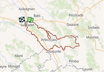
Randonnée V.T.T. de 41 km à découvrir à Nouvelle-Aquitaine, Landes, Samadet. Cette randonnée est proposée par potofe.

Description

Multirando de printemps
17/04/2022

Profil altimétrique

Localisation

Pays :
France
Région :
Nouvelle-Aquitaine
Département/Province :
Landes
Commune :
Samadet
Localité :
Unknown
Départ:(Dec)
Départ:(UTM)
702480 ; 4834527 (30T) N.

Randonnées à proximité

Randonnée Marche Serres-Gaston - Serres-Gaston Circuit de Lesgouarrigues  - Photo
Marche
DuMarsan

Marche

Facile
Serres-Gaston, Nouvelle-Aquitaine, Landes, France
15,9 km | 19,1 km-effort
2h 38min
Oui
Randonnée Marche Samadet - samadet - Photo
Marche
DuMarsan

Marche

Facile
Samadet, Nouvelle-Aquitaine, Landes, France
19,5 km | 22 km-effort
3h 53min
Oui


Fermer
Mes abonnements