


les etrils langon

lecmic
Utilisateur
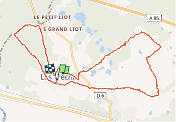

Longueur
14,3 km

Altitude max
136 m

Dénivelé positif
88 m
Km-Effort
15,4 km

Altitude min
119 m

Dénivelé négatif
88 m
Boucle
Oui
Date de création :
2022-05-04 11:48:46.657
Dernière modification :
2022-05-04 14:59:35.177
2h58
Difficulté : Très facile

Application GPS de randonnée GRATUITE
 SityTrail
IGN / Instituts géographiques
SityTrail Plus
Le monde est à vous
À propos
Randonnée Marche de 14,3 km à découvrir à Centre-Val de Loire, Loir-et-Cher, Langon-sur-Cher. Cette randonnée est proposée par lecmic.
Description
rando
Localisation
Pays :
France
Région :
Centre-Val de Loire
Département/Province :
Loir-et-Cher
Commune :
Langon-sur-Cher
Localité :
Unknown
Départ:(Dec)
Départ:(UTM)
409819 ; 5238531 (31T) N.
Commentaires