


Saint-Ouen-les-Vignes - Pocé-sur-Cisse 460 - 23.9km 460m 5h40 - 2022 05 29

Orcal37
Utilisateur GUIDE
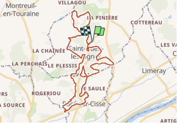

Longueur
24 km

Altitude max
114 m

Dénivelé positif
462 m
Km-Effort
30 km

Altitude min
58 m

Dénivelé négatif
461 m
Boucle
Oui
Date de création :
2022-05-29 09:34:04.756
Dernière modification :
2022-05-29 18:04:39.243
5h40
Difficulté : Moyen

Application GPS de randonnée GRATUITE
 SityTrail
IGN / Instituts géographiques
SityTrail Plus
Le monde est à vous
À propos
Randonnée Marche de 24 km à découvrir à Centre-Val de Loire, Indre-et-Loire, Saint-Ouen-les-Vignes. Cette randonnée est proposée par Orcal37.
Description
Saint-Ouen-les-Vignes - Pocé-sur-Cisse 460 - 23.9km 460m 5h40 - 2022 05 29
Photos


Localisation
Pays :
France
Région :
Centre-Val de Loire
Département/Province :
Indre-et-Loire
Commune :
Saint-Ouen-les-Vignes
Localité :
Unknown
Départ:(Dec)
Départ:(UTM)
349099 ; 5259604 (31T) N.
Commentaires