![](/images/other/stat-length.png)
![Randonnée Marche Névache - Lac rond puis Long par le refuge des Drayères - Photo](https://media.geolcdn.com/t/1900/400/ext.pjpeg?maxdim=2&url=https%3A%2F%2Fmedia.geolcdn.com%2Ff%2F5eef94ac-d003-441d-89a1-5ea73c2ab038.jpg)
Lac rond puis Long par le refuge des Drayères
RayFab
Utilisateur
![Longueur](/images/other/stat-length.png)
Longueur
9,3 km
![Altitude max](https://static1.geolcdn.com/siteimages/upload/files/1508320355ic_sort_altitude_max_24dp.png)
Altitude max
2464 m
![Dénivelé positif](https://static1.geolcdn.com/siteimages/upload/files/1508320355ic_sort_den_pos_24dp.png)
Dénivelé positif
459 m
![Km-Effort](/images/other/stat-length.png)
Km-Effort
15,4 km
![Altitude min](https://static1.geolcdn.com/siteimages/upload/files/1508320355ic_sort_altitude_min_24dp.png)
Altitude min
2021 m
![Dénivelé négatif](https://static1.geolcdn.com/siteimages/upload/files/1508320355ic_sort_den_neg_24dp.png)
Dénivelé négatif
459 m
![Boucle](https://static1.geolcdn.com/siteimages/upload/files/16400158638029165_repeat_loop_refresh_sync_direction_icon.png)
Boucle
Oui
Date de création :
2022-06-26 06:27:52.101
Dernière modification :
2022-06-27 06:01:56.225
![Marche](https://static1.geolcdn.com/sitytour/trail-icons/101.png)
3h35
Difficulté : Moyen
![Scannez ce code QR pour ouvrir la randonnée dans l'application SityTrail](https://capi.geolives.com/qq0zvz2zws4bq2lad0pu/sitytour/trails/3295622/qr.png?size=200)
Application GPS de randonnée GRATUITE
À propos
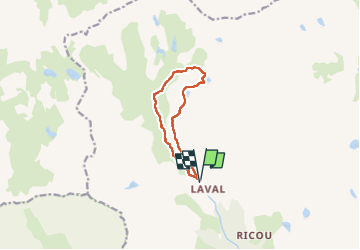
Randonnée Marche de 9,3 km à découvrir à Provence-Alpes-Côte d'Azur, Hautes-Alpes, Névache. Cette randonnée est proposée par RayFab.
Description
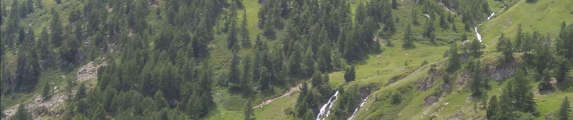
Belle randonnée fleuri où nous avons observé de nombreuses marmottes . La descente depuis le lac long est moins intéressante et caillouteuse mais très facile.
Localisation
Pays :
France
Région :
Provence-Alpes-Côte d'Azur
Département/Province :
Hautes-Alpes
Commune :
Névache
Localité :
Unknown
Départ:(Dec)
Départ:(UTM)
305195 ; 4992509 (32T) N.
Commentaires
Randonnées à proximité
![Randonnée Marche Névache - Névache - l'Argentière Lac Laramon Lac du Serpent - 10km 600m 3h10 (30mn) - 2014 06 01 - Photo](https://media.geolcdn.com/t/375/260/ext.jpg?maxdim=2&url=https%3A%2F%2Fservices.sitytrail.com%2FGeolivesWS%2FDownloadMedia.ashx%3FTrailID%3D308075%26Media%3Dfix__20140601111157.jpg)
![Marche Marche](https://static1.geolcdn.com/sitytour/trail-icons/101.png)
Névache - l'Argentière Lac Laramon Lac du Serpent - 10km 600m 3h10 (30mn) - 2...
Marche
Moyen
(2)
Névache,
Provence-Alpes-Côte d'Azur,
Hautes-Alpes,
France
![](/images/other/stat-length.png)
10 km | 18 km-effort
3h 10min
![](https://static1.geolcdn.com/siteimages/upload/files/16400158638029165_repeat_loop_refresh_sync_direction_icon.png)
Oui
![Randonnée Marche Névache - Col du Chardonnet - Névache - Photo](https://media.geolcdn.com/t/375/260/ext.jpg?maxdim=2&url=https%3A%2F%2Fservices.sitytrail.com%2FGeolivesWS%2FDownloadMedia.ashx%3FTrailID%3D172510%26Media%3D13871_4.jpg)
![Marche Marche](https://static1.geolcdn.com/sitytour/trail-icons/101.png)
Col du Chardonnet - Névache
Marche
Moyen
(3)
Névache,
Provence-Alpes-Côte d'Azur,
Hautes-Alpes,
France
![](/images/other/stat-length.png)
12,3 km | 23 km-effort
4h 0min
![](https://static1.geolcdn.com/siteimages/upload/files/16400158638029165_repeat_loop_refresh_sync_direction_icon.png)
Oui
![Randonnée Marche Le Monêtier-les-Bains - Le Grand Lac - Photo](https://media.geolcdn.com/t/375/260/ext.jpg?maxdim=2&url=https%3A%2F%2Fservices.sitytrail.com%2FGeolivesWS%2FDownloadMedia.ashx%3FTrailID%3D101251%26Media%3D741_2.jpg)
![Marche Marche](https://static1.geolcdn.com/sitytour/trail-icons/101.png)
Le Grand Lac
Marche
Difficile
(2)
Le Monêtier-les-Bains,
Provence-Alpes-Côte d'Azur,
Hautes-Alpes,
France
![](/images/other/stat-length.png)
5,2 km | 12,8 km-effort
5h 0min
![](https://static1.geolcdn.com/siteimages/upload/files/16400158638029165_repeat_loop_refresh_sync_direction_icon.png)
Non
![Randonnée Marche Le Monêtier-les-Bains - l'aiguillette du Lauzet par le grand lac - Photo](https://media.geolcdn.com/t/375/260/ext.jpg?maxdim=2&url=https%3A%2F%2Fmedia.geolcdn.com%2Ff%2F047d899e-dac4-4227-82df-970b78e389f9.jpg)
![Marche Marche](https://static1.geolcdn.com/sitytour/trail-icons/101.png)
l'aiguillette du Lauzet par le grand lac
Marche
Difficile
Le Monêtier-les-Bains,
Provence-Alpes-Côte d'Azur,
Hautes-Alpes,
France
![](/images/other/stat-length.png)
13,8 km | 29 km-effort
8h 39min
![](https://static1.geolcdn.com/siteimages/upload/files/16400158638029165_repeat_loop_refresh_sync_direction_icon.png)
Oui
![Randonnée Via ferrata Le Monêtier-les-Bains - Via ferrata Aiguillette du Lauzet - Photo](https://media.geolcdn.com/t/375/260/ext.jpg?maxdim=2&url=https%3A%2F%2Fmedia.geolcdn.com%2Ff%2Ff94c7ee2-184f-466f-9471-9131d6d51143.jpg)
![Via ferrata Via ferrata](https://static1.geolcdn.com/sitytour/trail-icons/902.png)
Via ferrata Aiguillette du Lauzet
Via ferrata
Moyen
Le Monêtier-les-Bains,
Provence-Alpes-Côte d'Azur,
Hautes-Alpes,
France
![](/images/other/stat-length.png)
9,5 km | 21 km-effort
2h 30min
![](https://static1.geolcdn.com/siteimages/upload/files/16400158638029165_repeat_loop_refresh_sync_direction_icon.png)
Oui
![Randonnée Marche Névache - la roche du Chardonnet - Photo](https://media.geolcdn.com/t/375/260/ext.jpg?maxdim=2&url=https%3A%2F%2Fservices.sitytrail.com%2FGeolivesWS%2FDownloadMedia.ashx%3FTrailID%3D1011228%26Media%3Dfix__20180726084936.jpg)
![Marche Marche](https://static1.geolcdn.com/sitytour/trail-icons/101.png)
la roche du Chardonnet
Marche
Moyen
Névache,
Provence-Alpes-Côte d'Azur,
Hautes-Alpes,
France
![](/images/other/stat-length.png)
16,6 km | 29 km-effort
7h 26min
![](https://static1.geolcdn.com/siteimages/upload/files/16400158638029165_repeat_loop_refresh_sync_direction_icon.png)
Oui
![Randonnée Marche Névache - Lacs Laramon et Serpent - Photo](https://media.geolcdn.com/t/375/260/ext.jpg?maxdim=2&url=https%3A%2F%2Fstatic1.geolcdn.com%2Fsiteimages%2Fupload%2Ffiles%2F1553511878bg_sport_marche.png)
![Marche Marche](https://static1.geolcdn.com/sitytour/trail-icons/101.png)
Lacs Laramon et Serpent
Marche
Moyen
(2)
Névache,
Provence-Alpes-Côte d'Azur,
Hautes-Alpes,
France
![](/images/other/stat-length.png)
10,4 km | 21 km-effort
6h 0min
![](https://static1.geolcdn.com/siteimages/upload/files/16400158638029165_repeat_loop_refresh_sync_direction_icon.png)
Oui
![Randonnée Marche Le Monêtier-les-Bains - Haut tour des Cerces - Photo](https://media.geolcdn.com/t/375/260/ext.jpg?maxdim=2&url=https%3A%2F%2Fstatic1.geolcdn.com%2Fsiteimages%2Fupload%2Ffiles%2F1553511878bg_sport_marche.png)
![Marche Marche](https://static1.geolcdn.com/sitytour/trail-icons/101.png)
Haut tour des Cerces
Marche
Très difficile
(1)
Le Monêtier-les-Bains,
Provence-Alpes-Côte d'Azur,
Hautes-Alpes,
France
![](/images/other/stat-length.png)
42 km | 77 km-effort
15h 27min
![](https://static1.geolcdn.com/siteimages/upload/files/16400158638029165_repeat_loop_refresh_sync_direction_icon.png)
Oui
![Randonnée Marche Névache - lacs laramon, du serpent, des gardioles et pic du lac blanc - Photo](https://media.geolcdn.com/t/375/260/ext.jpg?maxdim=2&url=https%3A%2F%2Fservices.sitytrail.com%2FGeolivesWS%2FDownloadMedia.ashx%3FTrailID%3D464369%26Media%3D32ea4843-d9bb-4918-8d64-5f3ab871e3cf.JPG)
![Marche Marche](https://static1.geolcdn.com/sitytour/trail-icons/101.png)
lacs laramon, du serpent, des gardioles et pic du lac blanc
Marche
Moyen
(1)
Névache,
Provence-Alpes-Côte d'Azur,
Hautes-Alpes,
France
![](/images/other/stat-length.png)
15,8 km | 31 km-effort
7h 30min
![](https://static1.geolcdn.com/siteimages/upload/files/16400158638029165_repeat_loop_refresh_sync_direction_icon.png)
Oui