Randonnée V.T.T. Coursan - la clape - Photo
 guillaume11
guillaume11

Utilisateur

© OpenStreetMap contributors
Longueur
Longueur
23 km
Altitude max
Altitude max
130 m
Dénivelé positif
Dénivelé positif
369 m
Km-Effort
Km-Effort  
28 km
Altitude min
Altitude min
-1 m
Dénivelé négatif
Dénivelé négatif
369 m
Boucle
Boucle
Oui
Date de création :
2014-12-10 00:00:00.0
Dernière modification :
2014-12-10 00:00:00.0

(0 Avis)

V.T.T.
V.T.T.
1h55
Difficulté : Moyen

Scannez ce code QR pour ouvrir la randonnée dans l'application SityTrail

Application GPS de randonnée GRATUITE

Logo SityTrail SityTrail

IGN / Instituts géographiques

Télécharger SityTrail sur l'App Store Télécharger SityTrail sur Google Play

Logo SityTrail SityTrail World

Le monde est à vous

Télécharger SityTrail sur l'App Store Télécharger SityTrail sur Google Play Télécharger SityTrail sur Huawei AppGallery

À propos

Randonnée V.T.T. de 23 km à découvrir à Occitanie, Aude, Coursan. Cette randonnée est proposée par guillaume11.

Profil altimétrique

Localisation

Pays :
France
Région :
Occitanie
Département/Province :
Aude
Commune :
Coursan
Localité :
Unknown
Départ:(Dec)
Départ:(UTM)
504507 ; 4786322 (31T) N.

Randonnées à proximité

Randonnée Vélo de route Narbonne - Narbonne - Bages - Port La Nouvelle - Narbonne - Photo
Vélo de route
Taupunzien

Vélo de route

Facile
(1)
Narbonne, Occitanie, Aude, France
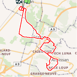
58 km | 63 km-effort
54min
Oui
Randonnée Marche Armissan - peyriac de mer - Photo
Marche
Francoise Seiller

Marche

Très facile
Armissan, Occitanie, Aude, France
64 km | 74 km-effort
43h 14min
Non
Randonnée Marche Narbonne - La Robine  - Photo
Marche
richardsimopons

Marche

Narbonne, Occitanie, Aude, France
12 km | 12,8 km-effort
2h 58min
Non
Randonnée Vélo Narbonne - EuroVelo 8 - Narbonne - Béziers - Photo
Vélo
GUIDE+

Vélo

Moyen
Narbonne, Occitanie, Aude, France
54 km | 59 km-effort
Inconnu
Non
Randonnée Cheval Cuxac-d'Aude - matinée rando cuxac - Photo
Cheval
herdtphil

Cheval

Difficile
Cuxac-d'Aude, Occitanie, Aude, France
28 km | 34 km-effort
4h 13min
Non
Randonnée sport Vinassan - La Clape /vinassan - Photo
sport
leballadeur

sport

Très facile
Vinassan, Occitanie, Aude, France
5,7 km | 7,2 km-effort
Inconnu
Oui
Randonnée sport Armissan - Armissan  - Photo
sport
trilles

sport

Très facile
Armissan, Occitanie, Aude, France
5 km | 6,6 km-effort
Inconnu
Non
Randonnée sport Vinassan - La Clape 7 - Photo
sport
leballadeur

sport

Très facile
Vinassan, Occitanie, Aude, France
6,3 km | 7,7 km-effort
Inconnu
Oui
Randonnée sport Vinassan - Clape 6 - Photo
sport
leballadeur

sport

Très facile
Vinassan, Occitanie, Aude, France
6 km | 7,4 km-effort
Inconnu
Oui


Fermer
Mes abonnements