Randonnée Marche Saint-Félix-de-Sorgues - la Loubiere  - Photo
 mjl12740
mjl12740

Utilisateur

© OpenStreetMap contributors
Longueur
Longueur
5,7 km
Altitude max
Altitude max
775 m
Dénivelé positif
Dénivelé positif
156 m
Km-Effort
Km-Effort  
7,8 km
Altitude min
Altitude min
697 m
Dénivelé négatif
Dénivelé négatif
155 m
Boucle
Boucle
Oui
Date de création :
2022-08-09 06:59:02.872
Dernière modification :
2022-08-09 09:05:33.358

(0 Avis)

Marche
Marche
2h05
Difficulté : Moyen

Scannez ce code QR pour ouvrir la randonnée dans l'application SityTrail

Application GPS de randonnée GRATUITE

Logo SityTrail SityTrail

IGN / Instituts géographiques

Télécharger SityTrail sur l'App Store Télécharger SityTrail sur Google Play

Logo SityTrail SityTrail World

Le monde est à vous

Télécharger SityTrail sur l'App Store Télécharger SityTrail sur Google Play Télécharger SityTrail sur Huawei AppGallery

À propos

Randonnée Marche de 5,7 km à découvrir à Occitanie, Aveyron, Saint-Félix-de-Sorgues. Cette randonnée est proposée par mjl12740.

Profil altimétrique

Photos

Localisation

Pays :
France
Région :
Occitanie
Département/Province :
Aveyron
Commune :
Saint-Félix-de-Sorgues
Localité :
Unknown
Départ:(UTM)
496818 ; 4856647 (31T) N.

Randonnées à proximité

Randonnée A pied Sylvanès - Boucle de Sylvanès - Photo
A pied
PRO

A pied

Facile
Sylvanès, Occitanie, Aveyron, France
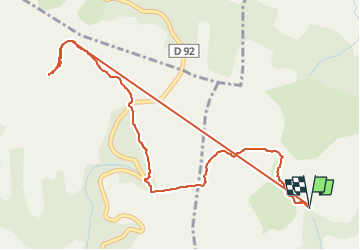
10,7 km | 14,8 km-effort
3h 21min
Oui
Randonnée Marche Montagnol - Le mazet trounas montagneol le mazet  - Photo
Marche
lablaquiere

Marche

Moyen
Montagnol, Occitanie, Aveyron, France
8,2 km | 11,3 km-effort
2h 0min
Oui
Randonnée Marche Sylvanès - Sylvanès - Photo
Marche
coulombf

Marche

Moyen
Sylvanès, Occitanie, Aveyron, France
13,7 km | 19,1 km-effort
4h 0min
Oui
Randonnée Marche Saint-Félix-de-Sorgues - st felix montagnol aventure - Photo
Marche
CASSISFRAMBOISE

Marche

Difficile
Saint-Félix-de-Sorgues, Occitanie, Aveyron, France
27 km | 37 km-effort
7h 49min
Oui
Randonnée Moteur Gissac - tournon camares  retour (simpl) - Photo
Moteur
lerouge8726

Moteur

Très facile
Gissac, Occitanie, Aveyron, France
325 km | 401 km-effort
11h 5min
Non
Randonnée Marche Saint-Félix-de-Sorgues - Aveyron - St-Felix-de-Sorgues circuit des Hospitaliers 13km 361m - Photo
Marche
RandoVal

Marche

Facile
Saint-Félix-de-Sorgues, Occitanie, Aveyron, France
12,8 km | 18,1 km-effort
3h 51min
Oui
Randonnée Marche Saint-Félix-de-Sorgues - Aveyron - St-Felix-de-Sorgues circuit des Hospitaliers 17km 514m - Photo
Marche
RandoVal

Marche

Moyen
Saint-Félix-de-Sorgues, Occitanie, Aveyron, France
17 km | 25 km-effort
5h 9min
Oui
Randonnée Marche Saint-Félix-de-Sorgues - Aveyron - St-Felix-de-Sorgues circuit des Hospitaliers 22km 695m - Photo
Marche
RandoVal

Marche

Difficile
Saint-Félix-de-Sorgues, Occitanie, Aveyron, France
22 km | 32 km-effort
6h 48min
Oui
Randonnée V.T.T. Saint-Félix-de-Sorgues - ceilhes le clapier moulés  - Photo
V.T.T.
lablaquiere

V.T.T.

Très difficile
Saint-Félix-de-Sorgues, Occitanie, Aveyron, France
54 km | 70 km-effort
3h 29min
Oui


Fermer
Mes abonnements