Randonnée Marche Regnière-Écluse - 8k-Regniére-Ecluse - Photo
 Robert62
Robert62

Utilisateur

© OpenStreetMap contributors
Longueur
Longueur
8,2 km
Altitude max
Altitude max
58 m
Dénivelé positif
Dénivelé positif
124 m
Km-Effort
Km-Effort  
9,8 km
Altitude min
Altitude min
9 m
Dénivelé négatif
Dénivelé négatif
124 m
Boucle
Boucle
Oui
Date de création :
2022-08-10 06:57:48.195
Dernière modification :
2022-08-18 18:48:35.094

(1 Avis)

Marche
Marche
1h53
Difficulté : Facile

Scannez ce code QR pour ouvrir la randonnée dans l'application SityTrail

Application GPS de randonnée GRATUITE

Logo SityTrail SityTrail

IGN / Instituts géographiques

Télécharger SityTrail sur l'App Store Télécharger SityTrail sur Google Play

Logo SityTrail SityTrail World

Le monde est à vous

Télécharger SityTrail sur l'App Store Télécharger SityTrail sur Google Play Télécharger SityTrail sur Huawei AppGallery

À propos

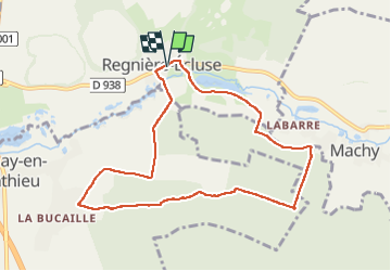
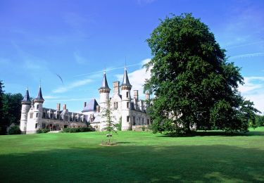
Randonnée Marche de 8,2 km à découvrir à Hauts-de-France, Somme, Regnière-Écluse. Cette randonnée est proposée par Robert62.

Description

marche

Profil altimétrique

Localisation

Pays :
France
Région :
Hauts-de-France
Département/Province :
Somme
Commune :
Regnière-Écluse
Localité :
Unknown
Départ:(UTM)
412373 ; 5570454 (31U) N.

Commentaires

Veuillez vous connecter pour laisser un commentaire ou une note


belle randonnée Merci Robert


Randonnées à proximité

Randonnée V.T.T. Bernay-en-Ponthieu - Fort Mahon - Photo
V.T.T.
callia1

V.T.T.

Très facile
(1)
Bernay-en-Ponthieu, Hauts-de-France, Somme, France
27 km | 30 km-effort
2h 3min
Non
Randonnée Marche Crécy-en-Ponthieu - forêt de Crecy  - Photo
Marche
Papy Diouf

Marche

Très facile
Crécy-en-Ponthieu, Hauts-de-France, Somme, France
7,1 km | 8,3 km-effort
1h 44min
Oui
Randonnée Autre activité Machy - Machy - Photo
Autre activité
pbruneel

Autre activité

Très facile
Machy, Hauts-de-France, Somme, France
5,9 km | 7 km-effort
1h 19min
Oui
Randonnée Marche Crécy-en-Ponthieu - Promenades en forêt de Crécy 2-5 - Photo
Marche
tracegps

Marche

Facile
Crécy-en-Ponthieu, Hauts-de-France, Somme, France
4,2 km | 4,8 km-effort
1h 19min
Oui
Randonnée Marche Crécy-en-Ponthieu - Promenades en forêt de Crécy 1-3 - Photo
Marche
tracegps

Marche

Facile
Crécy-en-Ponthieu, Hauts-de-France, Somme, France
4,8 km | 5,4 km-effort
1h 30min
Oui
Randonnée Marche Crécy-en-Ponthieu - Promenades en forêt de Crécy 1-2 - Photo
Marche
tracegps

Marche

Facile
Crécy-en-Ponthieu, Hauts-de-France, Somme, France
3,3 km | 3,8 km-effort
1h 0min
Oui
Randonnée Marche Forest-Montiers - Promenades en forêt de Crécy 1-1 - Photo
Marche
tracegps

Marche

Facile
Forest-Montiers, Hauts-de-France, Somme, France
4,1 km | 4,7 km-effort
1h 19min
Oui
Randonnée Marche Machy - Circuit du château de Régnières - Ecluse - Photo
Marche
tracegps

Marche

Moyen
Machy, Hauts-de-France, Somme, France
5,7 km | 6,7 km-effort
2h 0min
Oui
Randonnée A pied Regnière-Écluse - Château de Régnière-Ecluse - Photo
A pied
PRO

A pied

Facile
Regnière-Écluse, Hauts-de-France, Somme, France
5,7 km | 6,7 km-effort
1h 31min
Oui


Fermer
Mes abonnements