Randonnée Marche Lombers - Eglise Saint Sernin sentier des archéologues court - Photo

Eglise Saint Sernin sentier des archéologues court

 jpipacific
jpipacific

Utilisateur

© OpenStreetMap contributors
Longueur
Longueur
5,9 km
Altitude max
Altitude max
280 m
Dénivelé positif
Dénivelé positif
75 m
Km-Effort
Km-Effort  
6,9 km
Altitude min
Altitude min
217 m
Dénivelé négatif
Dénivelé négatif
77 m
Boucle
Boucle
Oui
Date de création :
2022-09-12 07:56:21.832
Dernière modification :
2022-09-12 10:29:09.163

(0 Avis)

Marche
Marche
1h15
Difficulté : Facile

Scannez ce code QR pour ouvrir la randonnée dans l'application SityTrail

Application GPS de randonnée GRATUITE

Logo SityTrail SityTrail

IGN / Instituts géographiques

Télécharger SityTrail sur l'App Store Télécharger SityTrail sur Google Play

Logo SityTrail SityTrail World

Le monde est à vous

Télécharger SityTrail sur l'App Store Télécharger SityTrail sur Google Play Télécharger SityTrail sur Huawei AppGallery

À propos

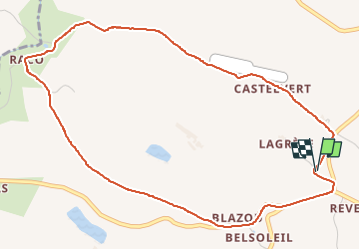
Randonnée Marche de 5,9 km à découvrir à Occitanie, Tarn, Lombers. Cette randonnée est proposée par jpipacific.

Description

Randonnée à partir du parking de l'Eglise et cimetière de Saint Sernin.
Cette randonnée emprunte le sentier des archéologues mais ne le suit pas en totalité et coupe par le sentier qui va de la route D4 au Raco.

Profil altimétrique

Localisation

Pays :
France
Région :
Occitanie
Département/Province :
Tarn
Commune :
Lombers
Localité :
Unknown
Départ:(UTM)
429783 ; 4852673 (31T) N.

Randonnées à proximité

Randonnée Marche Laboutarie - Laboutarié - Photo
Marche
tercla

Marche

Moyen
Laboutarie, Occitanie, Tarn, France
12,7 km | 15,1 km-effort
3h 0min
Oui
Randonnée Marche Orban - SityTrail - 3061378 - orban-chemin-des-cretes - Photo
Marche
chripaci

Marche

Moyen
Orban, Occitanie, Tarn, France
5,9 km | 7,5 km-effort
1h 42min
Oui
Randonnée Marche Sieurac - boucle de Sieurac - Photo
Marche
tabouelle

Marche

Très facile
Sieurac, Occitanie, Tarn, France
7,5 km | 8,8 km-effort
3h 29min
Oui
Randonnée A pied Lombers - Saint Pierre de Conils  - Photo
A pied
tercla

A pied

Facile
Lombers, Occitanie, Tarn, France
13,1 km | 15,7 km-effort
3h 34min
Oui
Randonnée Marche Poulan-Pouzols - Pouzols - Photo
Marche
tercla

Marche

Difficile
Poulan-Pouzols, Occitanie, Tarn, France
12,9 km | 15,4 km-effort
3h 29min
Oui
Randonnée Marche Lombers - archeologue variante - Photo
Marche
jpipacific

Marche

Difficile
Lombers, Occitanie, Tarn, France
10,7 km | 12,8 km-effort
2h 16min
Oui
Randonnée Course à pied Lombers - St PIerre Lombers via sentier des Romains - Photo
Course à pied
christel dalbin

Course à pied

Très facile
(2)
Lombers, Occitanie, Tarn, France
11,7 km | 14 km-effort
Inconnu
Oui
Randonnée Marche Lombers - Lombers formation  - Photo
Marche
Frayssinet

Marche

Très facile
Lombers, Occitanie, Tarn, France
6,4 km | 8,5 km-effort
1h 59min
Oui
Randonnée Vélo électrique Lombers - Randonnée cathare  - Photo
Vélo électrique
ktmetarn

Vélo électrique

Moyen
Lombers, Occitanie, Tarn, France
38 km | 48 km-effort
2h 46min
Oui


Fermer
Mes abonnements