Randonnée Marche Bellemagny - 90 Bellemagny - Vauthiermont - Photo

90 Bellemagny - Vauthiermont

 E.BURCK
E.BURCK

Utilisateur

© OpenStreetMap contributors
Longueur
Longueur
12,2 km
Altitude max
Altitude max
423 m
Dénivelé positif
Dénivelé positif
184 m
Km-Effort
Km-Effort  
14,6 km
Altitude min
Altitude min
337 m
Dénivelé négatif
Dénivelé négatif
184 m
Boucle
Boucle
Oui
Date de création :
2022-09-14 14:16:00.087
Dernière modification :
2022-09-14 14:18:54.949

(0 Avis)

Marche
Marche
3h19
Difficulté : Facile

Scannez ce code QR pour ouvrir la randonnée dans l'application SityTrail

Application GPS de randonnée GRATUITE

Logo SityTrail SityTrail

IGN / Instituts géographiques

Télécharger SityTrail sur l'App Store Télécharger SityTrail sur Google Play

Logo SityTrail SityTrail World

Le monde est à vous

Télécharger SityTrail sur l'App Store Télécharger SityTrail sur Google Play Télécharger SityTrail sur Huawei AppGallery

À propos

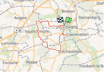
Randonnée Marche de 12,2 km à découvrir à Grand Est, Haut-Rhin, Bellemagny. Cette randonnée est proposée par E.BURCK.

Description

Une balade facile. Le circuit peut être raccourci et en cas de très mauvais temps nous pourrions maintenir le restaurant!
12 km dont 7.5 km le matin. Dénivelé: 184 m.
ACCÈS :  
- prendre la D483 à partir du rond point de Burnhaupt le Haut direction Belfort, sortir à gauche 800 m après le rond point de Soppe le Bas, direction Bellemagny.

PARKING :
- derrière la mairie de Bellemagny en face de l'abbaye.
47.6893,              7.0641 ou
N 47°41'21.5", E 7°03'50.8"

RESTAURATION :      
Auberge "La petite Charrue" 13 rue principale Vauthiermont
Tél: 03 84 23 89 14

Profil altimétrique

Localisation

Pays :
France
Région :
Grand Est
Département/Province :
Haut-Rhin
Commune :
Bellemagny
Localité :
Unknown
Départ:(UTM)
354731 ; 5283583 (32T) N.

Randonnées à proximité

Randonnée Marche Le Haut-Soultzbach - Lac de la Seigneurie (10/01/2019) - Photo
Marche
Richard68500

Marche

Facile
Le Haut-Soultzbach, Grand Est, Haut-Rhin, France
16,3 km | 19,5 km-effort
4h 24min
Oui
Randonnée Marche Burnhaupt-le-Bas - GR531 Diefmaten Gildwiller - Photo
Marche
helmut68

Marche

Facile
Burnhaupt-le-Bas, Grand Est, Haut-Rhin, France
6,1 km | 7,9 km-effort
1h 14min
Non
Randonnée V.T.T. Petitefontaine - grimpette au Baerenkopf réel  - Photo
V.T.T.
jibus90

V.T.T.

Difficile
Petitefontaine, Bourgogne-Franche-Comté, Territoire-de-Belfort, France
27 km | 39 km-effort
3h 9min
Oui
Randonnée Marche Le Haut-Soultzbach - compostelle - Photo
Marche
chantalwaltzer

Marche

Le Haut-Soultzbach, Grand Est, Haut-Rhin, France
28 km | 34 km-effort
9h 14min
Non
Randonnée V.T.T. Traubach-le-Haut - Traubach le haut  - Photo
V.T.T.
Alex Schlienger

V.T.T.

Facile
Traubach-le-Haut, Grand Est, Haut-Rhin, France
27 km | 34 km-effort
1h 48min
Oui
Randonnée Marche Lachapelle-sous-Rougemont - Lachapelle - Lac De Seigneurie (19/01/2023) - Photo
Marche
Richard68500

Marche

Facile
Lachapelle-sous-Rougemont, Bourgogne-Franche-Comté, Territoire-de-Belfort, France
11,6 km | 12,9 km-effort
3h 27min
Oui
Randonnée 4x4 Hecken - Alsace mardi 02 après midi - Photo
4x4
eldingue

4x4

Hecken, Grand Est, Haut-Rhin, France
87 km | 107 km-effort
3h 45min
Non
Randonnée V.T.T. Traubach-le-Haut - Traubach-le-haut / sternenberg - Photo
V.T.T.
Alex Schlienger

V.T.T.

Moyen
Traubach-le-Haut, Grand Est, Haut-Rhin, France
29 km | 36 km-effort
1h 48min
Oui
Randonnée A pied Sternenberg - TL 02/20 - Sternenberg - Croix St Eloi - Bellemagny - St Cosme - Guevenatten - et retour par Hecken - Photo
A pied
patrickbeyrath

A pied

Très facile
Sternenberg, Grand Est, Haut-Rhin, France
13,1 km | 16,3 km-effort
Inconnu
Oui


Fermer
Mes abonnements