Randonnée Marche Lachapelle-sous-Rougemont - Lachapelle - Lac De Seigneurie (19/01/2023) - Photo
 Richard68500
Richard68500

Utilisateur

© OpenStreetMap contributors
Longueur
Longueur
11,6 km
Altitude max
Altitude max
426 m
Dénivelé positif
Dénivelé positif
102 m
Km-Effort
Km-Effort  
12,9 km
Altitude min
Altitude min
379 m
Dénivelé négatif
Dénivelé négatif
102 m
Boucle
Boucle
Oui
Date de création :
2023-01-19 08:34:40.717
Dernière modification :
2023-01-19 15:53:58.912

(0 Avis)

Marche
Marche
3h27
Difficulté : Facile

Scannez ce code QR pour ouvrir la randonnée dans l'application SityTrail

Application GPS de randonnée GRATUITE

Logo SityTrail SityTrail

IGN / Instituts géographiques

Télécharger SityTrail sur l'App Store Télécharger SityTrail sur Google Play

Logo SityTrail SityTrail World

Le monde est à vous

Télécharger SityTrail sur l'App Store Télécharger SityTrail sur Google Play Télécharger SityTrail sur Huawei AppGallery

À propos

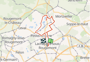
Randonnée Marche de 11,6 km à découvrir à Bourgogne-Franche-Comté, Territoire-de-Belfort, Lachapelle-sous-Rougemont. Cette randonnée est proposée par Richard68500.

Description

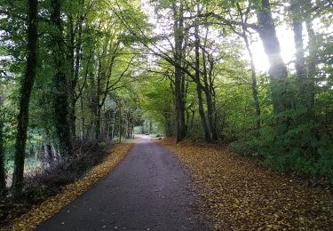
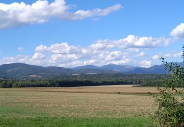
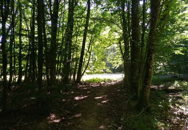
Randonnée promenadesans difficulté mais beaucoup de "gadoue"

Profil altimétrique

Localisation

Pays :
France
Région :
Bourgogne-Franche-Comté
Département/Province :
Territoire-de-Belfort
Commune :
Lachapelle-sous-Rougemont
Localité :
Unknown
Départ:(UTM)
351092 ; 5286168 (32T) N.

Randonnées à proximité

Randonnée Marche Sentheim - Sentheim Rossberg - Photo
Marche
helmut68

Marche

Moyen
(1)
Sentheim, Grand Est, Haut-Rhin, France
27 km | 40 km-effort
6h 11min
Oui
Randonnée Marche Lauw - 2022-07-14 Marche Lauw Refuge CAF Baerenkopf - Photo
Marche
GUIDE
holtzv

Marche

Très difficile
Lauw, Grand Est, Haut-Rhin, France
18,4 km | 31 km-effort
5h 35min
Non
Randonnée Marche Sentheim - Knapphutte Saegenkopf Hütte - Photo
Marche
helmut68

Marche

Moyen
Sentheim, Grand Est, Haut-Rhin, France
13,8 km | 17,2 km-effort
5h 11min
Oui
Randonnée Marche Sentheim - Montori - Photo
Marche
helmut68

Marche

Moyen
Sentheim, Grand Est, Haut-Rhin, France
17,7 km | 24 km-effort
4h 47min
Oui
Randonnée V.T.T. Sentheim - AperoDioller - Photo
V.T.T.
helmut68

V.T.T.

Facile
Sentheim, Grand Est, Haut-Rhin, France
24 km | 27 km-effort
1h 23min
Oui
Randonnée Marche Sentheim - Baerenkopf  - Photo
Marche
helmut68

Marche

Difficile
Sentheim, Grand Est, Haut-Rhin, France
33 km | 49 km-effort
7h 0min
Oui
Randonnée Marche Sentheim - Lac Seigneurie Soultzbach - Photo
Marche
helmut68

Marche

Facile
Sentheim, Grand Est, Haut-Rhin, France
10,9 km | 12,7 km-effort
3h 26min
Oui
Randonnée Marche Sentheim - Sentheim Bellemagny Sentheim  - Photo
Marche
helmut68

Marche

Moyen
Sentheim, Grand Est, Haut-Rhin, France
23 km | 28 km-effort
5h 37min
Oui
Randonnée Marche Sentheim - Buchberg - Rocher du Poilu  - Photo
Marche
helmut68

Marche

Difficile
Sentheim, Grand Est, Haut-Rhin, France
15,3 km | 22 km-effort
3h 45min
Oui


Fermer
Mes abonnements