


romorantin

lecmic
Utilisateur
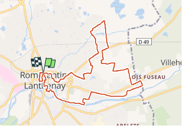

Longueur
11 km

Altitude max
107 m

Dénivelé positif
83 m
Km-Effort
12,1 km

Altitude min
84 m

Dénivelé négatif
81 m
Boucle
Oui
Date de création :
2022-10-02 06:30:06.6
Dernière modification :
2022-10-02 08:16:54.492
1h46
Difficulté : Facile

Application GPS de randonnée GRATUITE
 SityTrail
IGN / Instituts géographiques
SityTrail Plus
Le monde est à vous
À propos
Randonnée Marche de 11 km à découvrir à Centre-Val de Loire, Loir-et-Cher, Romorantin-Lanthenay. Cette randonnée est proposée par lecmic.
Description
octobre rose
Localisation
Pays :
France
Région :
Centre-Val de Loire
Département/Province :
Loir-et-Cher
Commune :
Romorantin-Lanthenay
Localité :
Unknown
Départ:(Dec)
Départ:(UTM)
405076 ; 5245999 (31T) N.
Commentaires