Randonnée V.T.T. Aix-la-Chapelle - Eu.AachenVerviers67D58km693m+VTC - Photo
 francois58
francois58

Utilisateur

© OpenStreetMap contributors
Longueur
Longueur
59 km
Altitude max
Altitude max
422 m
Dénivelé positif
Dénivelé positif
807 m
Km-Effort
Km-Effort  
70 km
Altitude min
Altitude min
165 m
Dénivelé négatif
Dénivelé négatif
845 m
Boucle
Boucle
Non
Date de création :
2017-06-21 00:00:00.0
Dernière modification :
2017-06-21 00:00:00.0

(0 Avis)

V.T.T.
V.T.T.
4h33
Difficulté : Moyen

Scannez ce code QR pour ouvrir la randonnée dans l'application SityTrail

Application GPS de randonnée GRATUITE

Logo SityTrail SityTrail

IGN / Instituts géographiques

Télécharger SityTrail sur l'App Store Télécharger SityTrail sur Google Play

Logo SityTrail SityTrail World

Le monde est à vous

Télécharger SityTrail sur l'App Store Télécharger SityTrail sur Google Play Télécharger SityTrail sur Huawei AppGallery

À propos

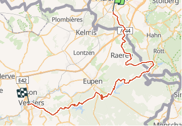
Randonnée V.T.T. de 59 km à découvrir à Rhénanie-du-Nord-Westphalie, Région urbaine d'Aix-la-Chapelle, Aix-la-Chapelle. Cette randonnée est proposée par francois58.

Description

Itinéraire VTC forestier en Eurégio joignant Aachen et Verviers via les lacs d'Eupen et de la Gileppe
Randonnée Elèves 2013 J4/4

Profil altimétrique

Localisation

Pays :
Allemagne
Région :
Rhénanie-du-Nord-Westphalie
Département/Province :
Région urbaine d'Aix-la-Chapelle
Commune :
Aix-la-Chapelle
Localité :
Aachen-Mitte
Départ:(Dec)
Départ:(UTM)
294433 ; 5626305 (32U) N.

Randonnées à proximité

Randonnée Marche Raeren - Aix-la-Chapelle_392 - Photo
Marche
GUIDE
mumu.larandonneuse

Marche

Moyen
(1)
Raeren, Wallonie, Liège, Belgique
13,2 km | 17,3 km-effort
3h 55min
Oui
Randonnée Marche Aix-la-Chapelle - Aix-la-Chapelle  - Photo
Marche
GUIDE
mumu.larandonneuse

Marche

Facile
(1)
Aix-la-Chapelle, Rhénanie-du-Nord-Westphalie, Région urbaine d'Aix-la-Chapelle, Allemagne
11,4 km | 15,4 km-effort
3h 30min
Oui
Randonnée Marche Aix-la-Chapelle - Aix-la-Chapelle  - Photo
Marche
GUIDE
mumu.larandonneuse

Marche

Facile
(1)
Aix-la-Chapelle, Rhénanie-du-Nord-Westphalie, Région urbaine d'Aix-la-Chapelle, Allemagne
11,1 km | 13,4 km-effort
3h 2min
Oui
Randonnée Marche Raeren - Lichtenbusch  - Photo
Marche
GUIDE
mumu.larandonneuse

Marche

Facile
(2)
Raeren, Wallonie, Liège, Belgique
14,8 km | 17 km-effort
3h 52min
Oui
Randonnée Marche Raeren - Hauset - Photo
Marche
GUIDE
mumu.larandonneuse

Marche

Facile
(1)
Raeren, Wallonie, Liège, Belgique
14,6 km | 17,8 km-effort
4h 2min
Oui
Randonnée Marche La Calamine - 20200730 - Les 3 Bornes 7.3 Km - Photo
Marche
GUIDE
pierreh01

Marche

Difficile
(1)
La Calamine, Wallonie, Liège, Belgique
7,4 km | 10,4 km-effort
1h 50min
Oui
Randonnée Marche La Calamine - Venn Trilogie (1er étape) - Photo
Marche
Godasses et Grosses Pattes

Marche

Moyen
(1)
La Calamine, Wallonie, Liège, Belgique
25 km | 30 km-effort
5h 0min
Non
Randonnée Marche Raeren - RB-Lg-30_Hauset_via-racc-2 - Photo
Marche
PRO

Marche

(3)
Raeren, Wallonie, Liège, Belgique
13,3 km | 15,9 km-effort
3h 37min
Oui
Randonnée Marche Raeren - RB-Lg-30_Hauset - Photo
Marche
PRO

Marche

(3)
Raeren, Wallonie, Liège, Belgique
19 km | 23 km-effort
5h 12min
Oui


Fermer
Mes abonnements