Randonnée Marche Lus-la-Croix-Haute - LA CAIRE-COMMANDERIE TOUSSIERE (PETIT CIRCUIT) - Photo

LA CAIRE-COMMANDERIE TOUSSIERE (PETIT CIRCUIT)

 RD78-38
RD78-38

Utilisateur

© OpenStreetMap contributors
Longueur
Longueur
7,7 km
Altitude max
Altitude max
1277 m
Dénivelé positif
Dénivelé positif
313 m
Km-Effort
Km-Effort  
11,9 km
Altitude min
Altitude min
998 m
Dénivelé négatif
Dénivelé négatif
310 m
Boucle
Boucle
Oui
Date de création :
2014-12-10 00:00:00.0
Dernière modification :
2020-07-11 00:25:11.12

(0 Avis)

Marche
Marche
2h44
Difficulté : Facile

Scannez ce code QR pour ouvrir la randonnée dans l'application SityTrail

Application GPS de randonnée GRATUITE

Logo SityTrail SityTrail

IGN / Instituts géographiques

Télécharger SityTrail sur l'App Store Télécharger SityTrail sur Google Play

Logo SityTrail SityTrail World

Le monde est à vous

Télécharger SityTrail sur l'App Store Télécharger SityTrail sur Google Play Télécharger SityTrail sur Huawei AppGallery

À propos

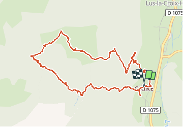
Randonnée Marche de 7,7 km à découvrir à Auvergne-Rhône-Alpes, Drôme, Lus-la-Croix-Haute. Cette randonnée est proposée par RD78-38.

Description

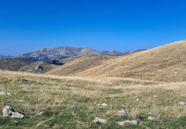
Petit circuit facile sans grand intérêt : circuit pratiquement toujours en forêt sans aucune vue.

Profil altimétrique

Localisation

Pays :
France
Région :
Auvergne-Rhône-Alpes
Département/Province :
Drôme
Commune :
Lus-la-Croix-Haute
Localité :
Unknown
Départ:(Dec)
Départ:(UTM)
713479 ; 4948718 (31T) N.

Randonnées à proximité

Randonnée Marche Glandage - Grimone-Le Jocou 12km - Photo
Marche
GUIDE
thonyc

Marche

Difficile
Glandage, Auvergne-Rhône-Alpes, Drôme, France
12 km | 24 km-effort
6h 0min
Oui
Randonnée Marche Lus-la-Croix-Haute - R48 - Gorges des Amayères - Photo
Marche
GUIDE+

Marche

Facile
Lus-la-Croix-Haute, Auvergne-Rhône-Alpes, Drôme, France
10,3 km | 17,5 km-effort
3h 1min
Non
Randonnée Marche Lus-la-Croix-Haute - Le Rognon - Photo
Marche
GAPIAN43

Marche

Moyen
(1)
Lus-la-Croix-Haute, Auvergne-Rhône-Alpes, Drôme, France
12,3 km | 22 km-effort
4h 33min
Oui
Randonnée Marche Saint-Julien-en-Beauchêne - ST JULIEN EN BEAUCHENE- VAUNIERES - Photo
Marche
BLANCHET

Marche

Moyen
(1)
Saint-Julien-en-Beauchêne, Provence-Alpes-Côte d'Azur, Hautes-Alpes, France
9,4 km | 18,4 km-effort
3h 59min
Non
Randonnée Marche Glandage - Le Jocou 2 - Photo
Marche
Marco05

Marche

Difficile
Glandage, Auvergne-Rhône-Alpes, Drôme, France
8,5 km | 18,1 km-effort
4h 0min
Oui
Randonnée Marche Lus-la-Croix-Haute - Pointe Feuillette - Photo
Marche
Marco05

Marche

Difficile
Lus-la-Croix-Haute, Auvergne-Rhône-Alpes, Drôme, France
10,5 km | 20 km-effort
4h 36min
Oui
Randonnée Marche Lus-la-Croix-Haute - Pointe feuillette  - Photo
Marche
ajd26

Marche

Moyen
Lus-la-Croix-Haute, Auvergne-Rhône-Alpes, Drôme, France
11,4 km | 21 km-effort
4h 52min
Oui
Randonnée Marche Glandage - Le Jocou-col de Seysse 12km. - Photo
Marche
chancha

Marche

Très difficile
Glandage, Auvergne-Rhône-Alpes, Drôme, France
11,6 km | 24 km-effort
5h 27min
Oui
Randonnée Marche Lus-la-Croix-Haute - MAS REBUFAT - POINTE FEUILLETTE  - Photo
Marche
RD78-38

Marche

Moyen
Lus-la-Croix-Haute, Auvergne-Rhône-Alpes, Drôme, France
11,7 km | 20 km-effort
3h 33min
Oui


Fermer
Mes abonnements