Randonnée Marche Pont-en-Royans - Grotte Balme Rousse - Photo
 cousam
cousam

Utilisateur

© OpenStreetMap contributors
Longueur
Longueur
15,7 km
Altitude max
Altitude max
862 m
Dénivelé positif
Dénivelé positif
1233 m
Km-Effort
Km-Effort  
32 km
Altitude min
Altitude min
199 m
Dénivelé négatif
Dénivelé négatif
1216 m
Boucle
Boucle
Oui
Date de création :
2023-01-07 08:38:40.375
Dernière modification :
2023-01-08 17:18:50.732

(0 Avis)

Marche
Marche
6h43
Difficulté : Difficile

Scannez ce code QR pour ouvrir la randonnée dans l'application SityTrail

Application GPS de randonnée GRATUITE

Logo SityTrail SityTrail

IGN / Instituts géographiques

Télécharger SityTrail sur l'App Store Télécharger SityTrail sur Google Play

Logo SityTrail SityTrail World

Le monde est à vous

Télécharger SityTrail sur l'App Store Télécharger SityTrail sur Google Play Télécharger SityTrail sur Huawei AppGallery

À propos

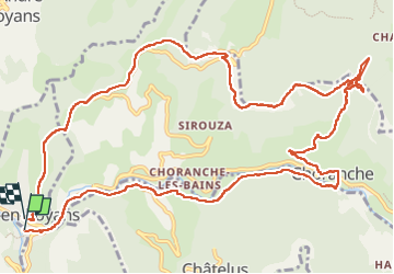
Randonnée Marche de 15,7 km à découvrir à Auvergne-Rhône-Alpes, Isère, Pont-en-Royans. Cette randonnée est proposée par cousam.

Description

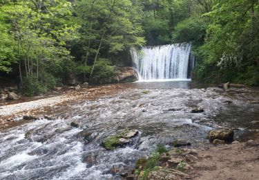
Boucle par la cascade et la grotte Gournier,
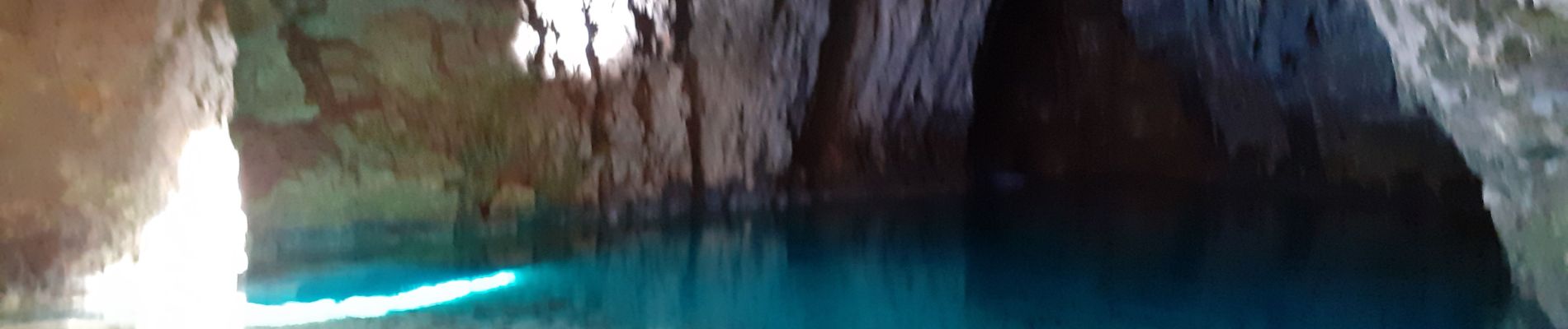
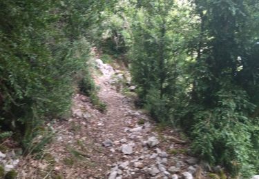
apres la grotte de la Balme rousse, passage avec une corde (attention aux cailloux  qui peuvent rouler).
Suivre la falaise ,assez Rock n'Roll ,mais sympa ,jusqu'au KM 10.5

Profil altimétrique

Photos

Localisation

Pays :
France
Région :
Auvergne-Rhône-Alpes
Département/Province :
Isère
Commune :
Pont-en-Royans
Localité :
Unknown
Départ:(UTM)
684500 ; 4992350 (31T) N.

Randonnées à proximité

Randonnée Marche Châtelus - Boucle Pas de l'Allier - Pas des Voutes - Photo
Marche
tracegps

Marche

Moyen
(1)
Châtelus, Auvergne-Rhône-Alpes, Isère, France
10,1 km | 22 km-effort
4h 30min
Oui
Randonnée Marche Choranche - La Grotte de Choranche - Photo
Marche
grfamily

Marche

Difficile
(1)
Choranche, Auvergne-Rhône-Alpes, Isère, France
17,8 km | 33 km-effort
7h 6min
Oui
Randonnée Marche Presles - Presles - rando amandière - (1) - Photo
Marche
calvaYnada

Marche

Très facile
(1)
Presles, Auvergne-Rhône-Alpes, Isère, France
5,6 km | 7,3 km-effort
1h 39min
Oui
Randonnée V.T.T. Presles - Presles  - Photo
V.T.T.
crocau

V.T.T.

Facile
(1)
Presles, Auvergne-Rhône-Alpes, Isère, France
10,4 km | 14,9 km-effort
2h 26min
Oui
Randonnée Marche Sainte-Eulalie-en-Royans - 26 ste eulalie - Photo
Marche
himba26100

Marche

Moyen
Sainte-Eulalie-en-Royans, Auvergne-Rhône-Alpes, Drôme, France
14,8 km | 27 km-effort
6h 43min
Non
Randonnée Marche Châtelus - 38 pabro charmatte - Photo
Marche
himba26100

Marche

Difficile
Châtelus, Auvergne-Rhône-Alpes, Isère, France
11,4 km | 29 km-effort
7h 43min
Oui
Randonnée Marche nordique Saint-Laurent-en-Royans - Circuit entre Saint-Laurent-en-Royans et Pont-en-Royans - Photo
Marche nordique
Emelle

Marche nordique

Moyen
Saint-Laurent-en-Royans, Auvergne-Rhône-Alpes, Drôme, France
13 km | 17,4 km-effort
5h 9min
Oui
Randonnée Marche Pont-en-Royans - 38 pont en Royans choranche presles - Photo
Marche
himba26100

Marche

Difficile
Pont-en-Royans, Auvergne-Rhône-Alpes, Isère, France
15,4 km | 30 km-effort
6h 52min
Oui
Randonnée Marche Choranche - Les 3 châteaux 2023 - Photo
Marche
crocau

Marche

Moyen
Choranche, Auvergne-Rhône-Alpes, Isère, France
3,3 km | 6,3 km-effort
1h 24min
Non


Fermer
Mes abonnements