Randonnée Marche Lauw - 2022-07-14 Marche Lauw Refuge CAF Baerenkopf - Photo

2022-07-14 Marche Lauw Refuge CAF Baerenkopf

 holtzv
holtzv

Utilisateur GUIDE

© OpenStreetMap contributors
Longueur
Longueur
18,4 km
Altitude max
Altitude max
1061 m
Dénivelé positif
Dénivelé positif
1082 m
Km-Effort
Km-Effort  
31 km
Altitude min
Altitude min
378 m
Dénivelé négatif
Dénivelé négatif
409 m
Boucle
Boucle
Non
Date de création :
2022-07-14 10:09:04.447
Dernière modification :
2022-07-18 08:09:09.593

(0 Avis)

Marche
Marche
5h35
Difficulté : Très difficile

Scannez ce code QR pour ouvrir la randonnée dans l'application SityTrail

Application GPS de randonnée GRATUITE

Logo SityTrail SityTrail

IGN / Instituts géographiques

Télécharger SityTrail sur l'App Store Télécharger SityTrail sur Google Play

Logo SityTrail SityTrail World

Le monde est à vous

Télécharger SityTrail sur l'App Store Télécharger SityTrail sur Google Play Télécharger SityTrail sur Huawei AppGallery

À propos

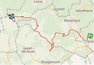
Randonnée Marche de 18,4 km à découvrir à Grand Est, Haut-Rhin, Lauw. Cette randonnée est proposée par holtzv.

Description

Départ de Lauw. Passage par le chalet Oberen Grambaechle pour le déjeuner, puis le col des trois bornes, les ruines du château Montori puis le Vieux Château de Rougemont, la chapelle Ste-Catherine, la colline du Sudel, l’abri Neuberg, pause Perrier à la ferme du Bruckenwald, l’étang Lachtelweiher, avant de remonter sur la ferme auberge du Lochberg pour le diner et ensuite le refuge CAF du Baerenkopf pour passer la nuit.

Profil altimétrique

Photos

Localisation

Pays :
France
Région :
Grand Est
Département/Province :
Haut-Rhin
Commune :
Lauw
Localité :
Unknown
Départ:(UTM)
351263 ; 5291081 (32T) N.

Randonnées à proximité

Randonnée Marche Masevaux-Niederbruck - Masevaux - Rossberg par le belvédère du Fuchsfelsen - Photo
Marche
Bart2015

Marche

Moyen
(1)
Masevaux-Niederbruck, Grand Est, Haut-Rhin, France
19,9 km | 34 km-effort
4h 44min
Oui
Randonnée Marche Sentheim - Sentheim Rossberg - Photo
Marche
helmut68

Marche

Moyen
(1)
Sentheim, Grand Est, Haut-Rhin, France
27 km | 40 km-effort
6h 11min
Oui
Randonnée A pied Sentheim - Sentier géologique du Wolfloch - Photo
A pied
PRO

A pied

Facile
Sentheim, Grand Est, Haut-Rhin, France
3,8 km | 4,8 km-effort
1h 5min
Non
Randonnée A pied Sentheim - Sentheim - Bergwald - Eichwald - Guevenheim - Sentheim - Photo
A pied
patrickbeyrath

A pied

Facile
(1)
Sentheim, Grand Est, Haut-Rhin, France
13,4 km | 16,6 km-effort
Inconnu
Oui
Randonnée Marche Masevaux-Niederbruck - Rando CLAS du 25/04/2024 - Photo
Marche
boubou68

Marche

Très difficile
Masevaux-Niederbruck, Grand Est, Haut-Rhin, France
17 km | 28 km-effort
4h 24min
Oui
Randonnée Marche Kirchberg - Rando du 11/04/2024  ..Marcheurs - Photo
Marche
boubou68

Marche

Très difficile
Kirchberg, Grand Est, Haut-Rhin, France
23 km | 37 km-effort
5h 37min
Oui
Randonnée Marche Sentheim - Knapphutte Saegenkopf Hütte - Photo
Marche
helmut68

Marche

Moyen
Sentheim, Grand Est, Haut-Rhin, France
13,8 km | 17,2 km-effort
5h 11min
Oui
Randonnée Marche Sentheim - Montori - Photo
Marche
helmut68

Marche

Moyen
Sentheim, Grand Est, Haut-Rhin, France
17,7 km | 24 km-effort
4h 47min
Oui
Randonnée V.T.T. Sentheim - AperoDioller - Photo
V.T.T.
helmut68

V.T.T.

Facile
Sentheim, Grand Est, Haut-Rhin, France
24 km | 27 km-effort
1h 23min
Oui


Fermer
Mes abonnements