Randonnée A pied Roderen - Roderen-Refuge du Hochburg Rammersmatt - Photo

Roderen-Refuge du Hochburg Rammersmatt

 JCLUTT
JCLUTT

Utilisateur

© OpenStreetMap contributors
Longueur
Longueur
10,5 km
Altitude max
Altitude max
763 m
Dénivelé positif
Dénivelé positif
435 m
Km-Effort
Km-Effort  
16,3 km
Altitude min
Altitude min
366 m
Dénivelé négatif
Dénivelé négatif
436 m
Boucle
Boucle
Oui
Date de création :
2023-03-08 09:16:35.097
Dernière modification :
2023-03-08 09:26:58.947

(0 Avis)

A pied
A pied
3h42
Difficulté : Facile

Scannez ce code QR pour ouvrir la randonnée dans l'application SityTrail

Application GPS de randonnée GRATUITE

Logo SityTrail SityTrail

IGN / Instituts géographiques

Télécharger SityTrail sur l'App Store Télécharger SityTrail sur Google Play

Logo SityTrail SityTrail World

Le monde est à vous

Télécharger SityTrail sur l'App Store Télécharger SityTrail sur Google Play Télécharger SityTrail sur Huawei AppGallery

À propos

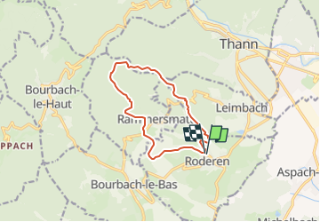
Randonnée A pied de 10,5 km à découvrir à Grand Est, Haut-Rhin, Roderen. Cette randonnée est proposée par JCLUTT.

Description

Belle balade hivernale, pas trop de dénivelé . De quoi se remettre en jambes !

Profil altimétrique

Localisation

Pays :
France
Région :
Grand Est
Département/Province :
Haut-Rhin
Commune :
Roderen
Localité :
Unknown
Départ:(Dec)
Départ:(UTM)
356894 ; 5293763 (32T) N.

Randonnées à proximité

Randonnée Marche Sentheim - Sentheim Rossberg - Photo
Marche
helmut68

Marche

Moyen
(1)
Sentheim, Grand Est, Haut-Rhin, France
27 km | 40 km-effort
6h 11min
Oui
Randonnée Marche Bourbach-le-Haut - Tour du Rossberg - Gsang - Thannerhubel - Photo
Marche
GUIDE
mumu.larandonneuse

Marche

Difficile
Bourbach-le-Haut, Grand Est, Haut-Rhin, France
11,4 km | 18,5 km-effort
4h 12min
Oui
Randonnée A pied Sentheim - Sentier géologique du Wolfloch - Photo
A pied
PRO

A pied

Facile
Sentheim, Grand Est, Haut-Rhin, France
3,8 km | 4,8 km-effort
1h 5min
Non
Randonnée A pied Sentheim - Sentheim - Bergwald - Eichwald - Guevenheim - Sentheim - Photo
A pied
patrickbeyrath

A pied

Facile
(1)
Sentheim, Grand Est, Haut-Rhin, France
13,4 km | 16,6 km-effort
Inconnu
Oui
Randonnée Marche Thann - JD 14/20 Thann-roche--albert--grumbachkopf - Photo
Marche
argonneuweg

Marche

Moyen
(1)
Thann, Grand Est, Haut-Rhin, France
7,6 km | 12 km-effort
2h 28min
Oui
Randonnée Marche Bitschwiller-lès-Thann - 68 Col du Hundsrück  - FA Gsang - retour ThannerHubel - Photo
Marche

Marche

Moyen
(1)
Bitschwiller-lès-Thann, Grand Est, Haut-Rhin, France
11,2 km | 18,4 km-effort
3h 48min
Oui
Randonnée Marche Sentheim - Knapphutte Saegenkopf Hütte - Photo
Marche
helmut68

Marche

Moyen
Sentheim, Grand Est, Haut-Rhin, France
13,8 km | 17,2 km-effort
5h 11min
Oui
Randonnée Marche Burnhaupt-le-Haut - Rando du 09/02/2024 par Alain...Pont d'Aspach - Photo
Marche
boubou68

Marche

Très difficile
Burnhaupt-le-Haut, Grand Est, Haut-Rhin, France
22 km | 27 km-effort
5h 12min
Oui
Randonnée Marche Sentheim - Montori - Photo
Marche
helmut68

Marche

Moyen
Sentheim, Grand Est, Haut-Rhin, France
17,7 km | 24 km-effort
4h 47min
Oui


Fermer
Mes abonnements