![](/images/other/stat-length.png)
![Randonnée Moto Remicourt - Roadtrip moto jusque Nice - Photo](https://media.geolcdn.com/t/1900/400/ext.pjpeg?maxdim=2&url=https%3A%2F%2Fmedia.geolcdn.com%2Ff%2F3bda600d-dbf7-4c86-95d7-816bcbcf2ca4.png)
Roadtrip moto jusque Nice
Tim0130
Utilisateur
![Longueur](/images/other/stat-length.png)
![Altitude max](https://static1.geolcdn.com/siteimages/upload/files/1508320355ic_sort_altitude_max_24dp.png)
![Dénivelé positif](https://static1.geolcdn.com/siteimages/upload/files/1508320355ic_sort_den_pos_24dp.png)
![Km-Effort](/images/other/stat-length.png)
![Altitude min](https://static1.geolcdn.com/siteimages/upload/files/1508320355ic_sort_altitude_min_24dp.png)
![Dénivelé négatif](https://static1.geolcdn.com/siteimages/upload/files/1508320355ic_sort_den_neg_24dp.png)
![Boucle](https://static1.geolcdn.com/siteimages/upload/files/16400158638029165_repeat_loop_refresh_sync_direction_icon.png)
![Moto](https://static1.geolcdn.com/sitytour/trail-icons/402.png)
45h00
Difficulté : Très difficile
![Scannez ce code QR pour ouvrir la randonnée dans l'application SityTrail](https://capi.geolives.com/qq0zvz2zws4bq2lad0pu/sitytour/trails/3608250/qr.png?size=200)
Application GPS de randonnée GRATUITE
À propos
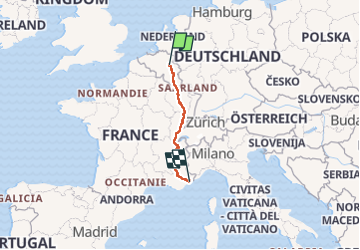
Randonnée Moto de 1349 km à découvrir à Wallonie, Liège, Remicourt. Cette randonnée est proposée par Tim0130.
Description
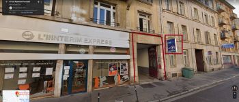
Jour 1 (stop Nancy => 343 Km)
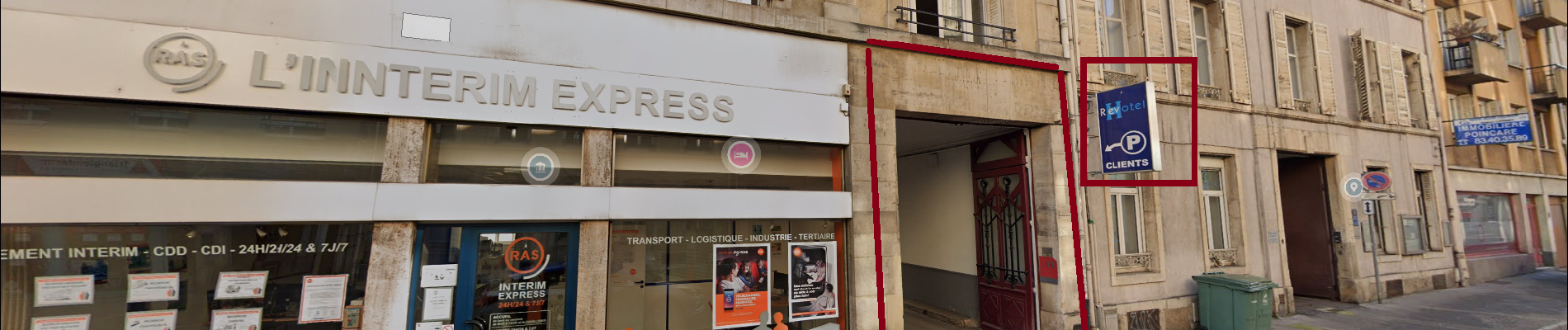
- Revotel Centre Gare et Congrès
- Adresse : 43 Rue Raymond Poincaré, 54000 Nancy
- Téléphone : 33 3 83 28 02 13
- Web: https://www.revotel-hotel.com/fr/
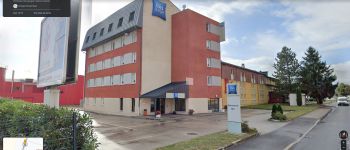
Jour 2 (stop Pontarlier => 314Km. Total Km:657Km)
- Ibis budget Pontarlier
-Adresse: 29 rue Denis Papin, 25300 Pontarlier
-Gps: 46.909624, 6.335264
-Téléphone: 33 892 70 04 46
-Mail: h7418@accor.com
-Web: https://all.accor.com/hotel/7418/index.fr.shtml?
dateIn=&nights=&compositions=1&stayplus=false&snu=false#section-location
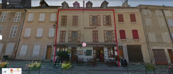
Jour 3 (stop Mens => 369Km. Total Km: 1019Km)
- Les Dimathal
- Adresse: 91 rue du Breuil, 38710 Mens
- Téléphone: 33 6 82 97 03 44 ou 33 6 85 58 98 66
-Mail: lalezan@orange.fr
- Web: https://www.isere-tourisme.com/hebergement- locatif/les-dimathal
Jour 4 (arrivée Nice)
Localisation
Commentaires
Randonnées à proximité
![Randonnée Marche Waremme - Lantremange - Photo](https://media.geolcdn.com/t/375/260/ext.jpg?maxdim=2&url=https%3A%2F%2Fstatic1.geolcdn.com%2Fsiteimages%2Fupload%2Ffiles%2F1553511878bg_sport_marche.png)
![Marche Marche](https://static1.geolcdn.com/sitytour/trail-icons/101.png)
![Randonnée Marche Tongres - Promenade de la beauté cachée à Lauw - Photo](https://media.geolcdn.com/t/375/260/ext.jpg?maxdim=2&url=https%3A%2F%2Fmedia.geolcdn.com%2Ff%2Fe09aa99f-84cb-4b46-8a0c-50d633d5a7ef.jpg)
![Marche Marche](https://static1.geolcdn.com/sitytour/trail-icons/101.png)
Marche
![](/images/other/stat-length.png)
![](https://static1.geolcdn.com/siteimages/upload/files/16400158638029165_repeat_loop_refresh_sync_direction_icon.png)
![Randonnée A pied Tongres - Lauw Rode pijl - Photo](https://media.geolcdn.com/t/375/260/ext.jpg?maxdim=2&url=https%3A%2F%2Fmedia.geolcdn.com%2Ff%2F84c62846-6479-45e1-9eb2-db2c2970fa27.jpeg)
![A pied A pied](https://static1.geolcdn.com/sitytour/trail-icons/100.png)
A pied
![](/images/other/stat-length.png)
![](https://static1.geolcdn.com/siteimages/upload/files/16400158638029165_repeat_loop_refresh_sync_direction_icon.png)
![Randonnée Marche Waremme - Waremme ( autour de la vallée du Geer) - Photo](https://media.geolcdn.com/t/375/260/ext.jpg?maxdim=2&url=https%3A%2F%2Fmedia.geolcdn.com%2Ff%2Fe56e87e8-dda3-4c10-9253-9701ae5a37ab.jpg)
![Marche Marche](https://static1.geolcdn.com/sitytour/trail-icons/101.png)
Marche
![](/images/other/stat-length.png)
![](https://static1.geolcdn.com/siteimages/upload/files/16400158638029165_repeat_loop_refresh_sync_direction_icon.png)
![Randonnée Marche Waremme - Oleye - bous de Horne - Photo](https://media.geolcdn.com/t/375/260/ext.jpg?maxdim=2&url=https%3A%2F%2Fmedia.geolcdn.com%2Ff%2F1a016a95-1857-49e8-88fe-ed16c9189e3e.jpg)
![Marche Marche](https://static1.geolcdn.com/sitytour/trail-icons/101.png)
Marche
![](/images/other/stat-length.png)
![](https://static1.geolcdn.com/siteimages/upload/files/16400158638029165_repeat_loop_refresh_sync_direction_icon.png)
![Randonnée Marche Crisnée - Le long de la rivière Geer à Lauw - Photo](https://media.geolcdn.com/t/375/260/ext.jpg?maxdim=2&url=https%3A%2F%2Fmedia.geolcdn.com%2Ff%2F40f99ee7-f765-490b-b3f6-81270c870ae1.jpg)
![Marche Marche](https://static1.geolcdn.com/sitytour/trail-icons/101.png)
Marche
![](/images/other/stat-length.png)
![](https://static1.geolcdn.com/siteimages/upload/files/16400158638029165_repeat_loop_refresh_sync_direction_icon.png)
![Randonnée Marche Tongres - Verborgen moois Lauw - Photo](https://media.geolcdn.com/t/375/260/ext.jpg?maxdim=2&url=https%3A%2F%2Fmedia.geolcdn.com%2Ff%2F549c799f-5307-40dd-a396-92ee7721cd10.jpg)
![Marche Marche](https://static1.geolcdn.com/sitytour/trail-icons/101.png)
Marche
![](/images/other/stat-length.png)
![](https://static1.geolcdn.com/siteimages/upload/files/16400158638029165_repeat_loop_refresh_sync_direction_icon.png)
![Randonnée Marche Remicourt - Momalle - Photo](https://media.geolcdn.com/t/375/260/ext.jpg?maxdim=2&url=https%3A%2F%2Fmedia.geolcdn.com%2Ff%2Fb99e2946-c98e-4c2c-a361-48f607a3ba2c.jpg)
![Marche Marche](https://static1.geolcdn.com/sitytour/trail-icons/101.png)
Marche
![](/images/other/stat-length.png)
![](https://static1.geolcdn.com/siteimages/upload/files/16400158638029165_repeat_loop_refresh_sync_direction_icon.png)
![Randonnée Autre activité Crisnée - crisnee 2013 1123 - Photo](https://media.geolcdn.com/t/375/260/ext.jpg?maxdim=2&url=https%3A%2F%2Fservices.sitytrail.com%2FGeolivesWS%2FDownloadMedia.ashx%3FTrailID%3D234124%26Media%3Dfix__20131123151158.jpg)
![Autre activité Autre activité](https://static1.geolcdn.com/sitytour/trail-icons/900.png)
Autre activité
![](/images/other/stat-length.png)
![](https://static1.geolcdn.com/siteimages/upload/files/16400158638029165_repeat_loop_refresh_sync_direction_icon.png)