Randonnée Marche Ampuis - Le Grand plomb CB 23 - Photo
 boothcs
boothcs

Utilisateur

© OpenStreetMap contributors
Longueur
Longueur
10,8 km
Altitude max
Altitude max
526 m
Dénivelé positif
Dénivelé positif
309 m
Km-Effort
Km-Effort  
14,9 km
Altitude min
Altitude min
327 m
Dénivelé négatif
Dénivelé négatif
310 m
Boucle
Boucle
Oui
Date de création :
2023-04-18 07:57:36.925
Dernière modification :
2023-04-20 17:15:27.028

(0 Avis)

Marche
Marche
3h23
Difficulté : Difficile

Scannez ce code QR pour ouvrir la randonnée dans l'application SityTrail

Application GPS de randonnée GRATUITE

Logo SityTrail SityTrail

IGN / Instituts géographiques

Télécharger SityTrail sur l'App Store Télécharger SityTrail sur Google Play

Logo SityTrail SityTrail World

Le monde est à vous

Télécharger SityTrail sur l'App Store Télécharger SityTrail sur Google Play Télécharger SityTrail sur Huawei AppGallery

À propos

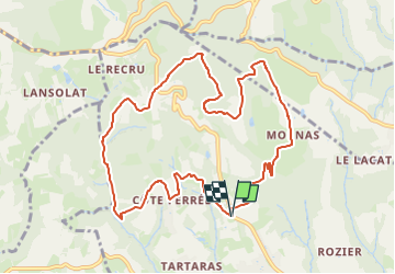
Randonnée Marche de 10,8 km à découvrir à Auvergne-Rhône-Alpes, Rhône, Ampuis. Cette randonnée est proposée par boothcs.

Description

Belle balade sans problèmes 2023-04-19

Profil altimétrique

Localisation

Pays :
France
Région :
Auvergne-Rhône-Alpes
Département/Province :
Rhône
Commune :
Ampuis
Localité :
Unknown
Départ:(UTM)
640368 ; 5040718 (31T) N.

Randonnées à proximité

Randonnée Marche Condrieu - ravin de l'arbuet - Photo
Marche
dan69390

Marche

Très facile
(1)
Condrieu, Auvergne-Rhône-Alpes, Rhône, France
7,2 km | 10 km-effort
2h 52min
Oui
Randonnée Marche Saint-Romain-en-Gal - le grisard - Photo
Marche
servemichel

Marche

Moyen
(1)
Saint-Romain-en-Gal, Auvergne-Rhône-Alpes, Rhône, France
5,3 km | 7,9 km-effort
1h 48min
Oui
Randonnée Marche Reventin-Vaugris - 38-reventin-10km-325m - Photo
Marche
SyMA

Marche

Facile
Reventin-Vaugris, Auvergne-Rhône-Alpes, Isère, France
10 km | 14,3 km-effort
3h 5min
Oui
Randonnée Marche Loire-sur-Rhône - 69-loire-sur-rhone2-pet-de-loup-18km-560m - Photo
Marche
SyMA

Marche

Moyen
(1)
Loire-sur-Rhône, Auvergne-Rhône-Alpes, Rhône, France
17,7 km | 25 km-effort
3h 3min
Oui
Randonnée Marche Reventin-Vaugris - REVENTIN 18 JC - Photo
Marche
Clubléorando

Marche

Très facile
(1)
Reventin-Vaugris, Auvergne-Rhône-Alpes, Isère, France
7,3 km | 10,5 km-effort
2h 12min
Oui
Randonnée Marche Reventin-Vaugris - REVENTIN VAUGRIS 2 JC - Photo
Marche
Clubléorando

Marche

Très facile
(1)
Reventin-Vaugris, Auvergne-Rhône-Alpes, Isère, France
12,9 km | 17,8 km-effort
3h 45min
Oui
Randonnée Marche Ampuis - AMPUIS JC - Photo
Marche
Clubléorando

Marche

Très facile
(1)
Ampuis, Auvergne-Rhône-Alpes, Rhône, France
9,7 km | 12,1 km-effort
3h 10min
Oui
Randonnée V.T.T. Reventin-Vaugris - Écureuil 2013 - Photo
V.T.T.
marc6262

V.T.T.

Difficile
(1)
Reventin-Vaugris, Auvergne-Rhône-Alpes, Isère, France
30 km | 40 km-effort
2h 34min
Oui
Randonnée Marche Condrieu - condrieu - Photo
Marche
Jean-Luc Villermaux

Marche

Difficile
Condrieu, Auvergne-Rhône-Alpes, Rhône, France
14 km | 18,7 km-effort
3h 32min
Oui


Fermer
Mes abonnements