Randonnée Marche Reventin-Vaugris - 38-reventin-10km-325m - Photo
 SyMA
SyMA

Utilisateur

© OpenStreetMap contributors
Longueur
Longueur
10 km
Altitude max
Altitude max
383 m
Dénivelé positif
Dénivelé positif
323 m
Km-Effort
Km-Effort  
14,3 km
Altitude min
Altitude min
260 m
Dénivelé négatif
Dénivelé négatif
324 m
Boucle
Boucle
Oui
Date de création :
2023-10-18 12:17:07.064
Dernière modification :
2023-10-21 04:10:30.06

(0 Avis)

Marche
Marche
3h05
Difficulté : Facile

Scannez ce code QR pour ouvrir la randonnée dans l'application SityTrail

Application GPS de randonnée GRATUITE

Logo SityTrail SityTrail

IGN / Instituts géographiques

Télécharger SityTrail sur l'App Store Télécharger SityTrail sur Google Play

Logo SityTrail SityTrail World

Le monde est à vous

Télécharger SityTrail sur l'App Store Télécharger SityTrail sur Google Play Télécharger SityTrail sur Huawei AppGallery

À propos

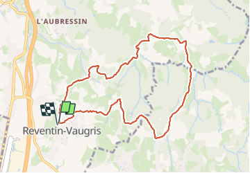
Randonnée Marche de 10 km à découvrir à Auvergne-Rhône-Alpes, Isère, Reventin-Vaugris. Cette randonnée est proposée par SyMA.

Description

Départ mairie de reventin vaugris

Profil altimétrique

Photos

Localisation

Pays :
France
Région :
Auvergne-Rhône-Alpes
Département/Province :
Isère
Commune :
Reventin-Vaugris
Localité :
Unknown
Départ:(UTM)
643874 ; 5036614 (31T) N.

Randonnées à proximité

Randonnée V.T.T. Les Côtes-d'Arey - Autour des Cotes d'Arey - Photo
V.T.T.
marc6262

V.T.T.

Difficile
(2)
Les Côtes-d'Arey, Auvergne-Rhône-Alpes, Isère, France
20 km | 26 km-effort
Inconnu
Oui
Randonnée Marche Reventin-Vaugris - REVENTIN 18 JC - Photo
Marche
Clubléorando

Marche

Très facile
(1)
Reventin-Vaugris, Auvergne-Rhône-Alpes, Isère, France
7,3 km | 10,5 km-effort
2h 12min
Oui
Randonnée Marche Reventin-Vaugris - REVENTIN VAUGRIS 2 JC - Photo
Marche
Clubléorando

Marche

Très facile
(1)
Reventin-Vaugris, Auvergne-Rhône-Alpes, Isère, France
12,9 km | 17,8 km-effort
3h 45min
Oui
Randonnée Marche Ampuis - AMPUIS JC - Photo
Marche
Clubléorando

Marche

Très facile
(1)
Ampuis, Auvergne-Rhône-Alpes, Rhône, France
9,7 km | 12,1 km-effort
3h 10min
Oui
Randonnée V.T.T. Reventin-Vaugris - Écureuil 2013 - Photo
V.T.T.
marc6262

V.T.T.

Difficile
(1)
Reventin-Vaugris, Auvergne-Rhône-Alpes, Isère, France
30 km | 40 km-effort
2h 34min
Oui
Randonnée Marche Vienne - 2023-10-08 - St Alban les Vignes - La Balme -  Les Barres - Photo
Marche
beaufortchop

Marche

Facile
Vienne, Auvergne-Rhône-Alpes, Isère, France
16,4 km | 24 km-effort
4h 53min
Oui
Randonnée A pied Vienne - Vossères - Croix des Chasseurs - fixme - Photo
A pied
PRO

A pied

Facile
Vienne, Auvergne-Rhône-Alpes, Isère, France
4,4 km | 5,5 km-effort
1h 15min
Non
Randonnée Marche Reventin-Vaugris - Reventin - Photo
Marche
beaufortchop

Marche

Très facile
Reventin-Vaugris, Auvergne-Rhône-Alpes, Isère, France
2,7 km | 4,1 km-effort
45min
Oui
Randonnée Marche Ampuis - Le Grand plomb CB 23 - Photo
Marche
boothcs

Marche

Difficile
Ampuis, Auvergne-Rhône-Alpes, Rhône, France
10,8 km | 14,9 km-effort
3h 23min
Oui


Fermer
Mes abonnements