![](/images/other/stat-length.png)
![Randonnée Marche Viroinval - Balade dans le Viroinval - Olloy - Photo](https://media.geolcdn.com/t/1900/400/ext.pjpeg?maxdim=2&url=https%3A%2F%2Fmedia.geolcdn.com%2Ff%2Fc6d33371-3ecb-4ffa-ae45-9aaa97ba85ec.jpeg)
Balade dans le Viroinval - Olloy
Desrumaux
Utilisateur GUIDE
![Longueur](/images/other/stat-length.png)
Longueur
9,7 km
![Altitude max](https://static1.geolcdn.com/siteimages/upload/files/1508320355ic_sort_altitude_max_24dp.png)
Altitude max
315 m
![Dénivelé positif](https://static1.geolcdn.com/siteimages/upload/files/1508320355ic_sort_den_pos_24dp.png)
Dénivelé positif
260 m
![Km-Effort](/images/other/stat-length.png)
Km-Effort
13,2 km
![Altitude min](https://static1.geolcdn.com/siteimages/upload/files/1508320355ic_sort_altitude_min_24dp.png)
Altitude min
133 m
![Dénivelé négatif](https://static1.geolcdn.com/siteimages/upload/files/1508320355ic_sort_den_neg_24dp.png)
Dénivelé négatif
259 m
![Boucle](https://static1.geolcdn.com/siteimages/upload/files/16400158638029165_repeat_loop_refresh_sync_direction_icon.png)
Boucle
Oui
Date de création :
2023-04-23 06:53:19.165
Dernière modification :
2023-04-26 06:12:43.535
![Marche](https://static1.geolcdn.com/sitytour/trail-icons/101.png)
2h59
Difficulté : Difficile
![Scannez ce code QR pour ouvrir la randonnée dans l'application SityTrail](https://capi.geolives.com/qq0zvz2zws4bq2lad0pu/sitytour/trails/3632096/qr.png?size=200)
Application GPS de randonnée GRATUITE
À propos
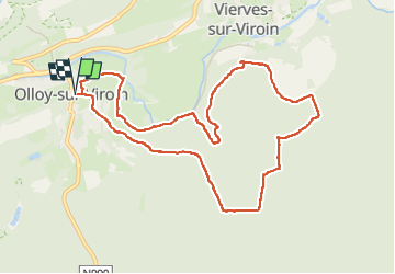
Randonnée Marche de 9,7 km à découvrir à Wallonie, Namur, Viroinval. Cette randonnée est proposée par Desrumaux.
Description
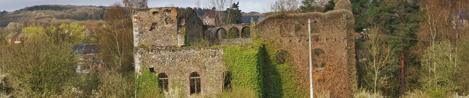
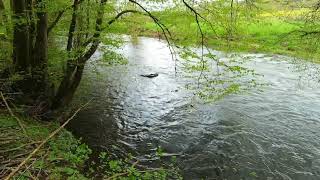
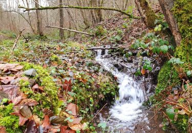
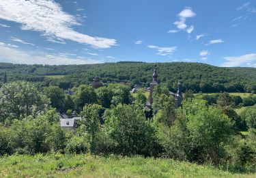
Jolie balade dans le Viroinval au départ du village de Olloy par les bois environnant et le point de vue du Grand mont avec une jolie vue sur le village de Vierves
Localisation
Pays :
Belgique
Région :
Wallonie
Département/Province :
Namur
Commune :
Viroinval
Localité :
Unknown
Départ:(Dec)
Départ:(UTM)
615054 ; 5547951 (31U) N.
Commentaires
Randonnées à proximité
![Randonnée Marche Viroinval - RB-Na-13_Nismes - Photo](https://media.geolcdn.com/t/375/260/ext.jpg?maxdim=2&url=https%3A%2F%2Fservices.sitytrail.com%2FGeolivesWS%2FDownloadMedia.ashx%3FTrailID%3D260747%26Media%3Dff8837a8-8f2b-4db1-ba1e-88015d1f5e8a.jpg)
![Marche Marche](https://static1.geolcdn.com/sitytour/trail-icons/101.png)
RB-Na-13_Nismes
Marche
Moyen
(12)
Viroinval,
Wallonie,
Namur,
Belgique
![](/images/other/stat-length.png)
22 km | 28 km-effort
6h 4min
![](https://static1.geolcdn.com/siteimages/upload/files/16400158638029165_repeat_loop_refresh_sync_direction_icon.png)
Oui
![Randonnée Marche Viroinval - Balade dans le Viroinval - De Vierves à Olloy - Photo](https://media.geolcdn.com/t/375/260/ext.jpg?maxdim=2&url=https%3A%2F%2Fmedia.geolcdn.com%2Ff%2Feea3f008-fef3-4865-8c34-a0378b4c67ed.jpeg)
![Marche Marche](https://static1.geolcdn.com/sitytour/trail-icons/101.png)
Balade dans le Viroinval - De Vierves à Olloy
Marche
Très facile
(2)
Viroinval,
Wallonie,
Namur,
Belgique
![](/images/other/stat-length.png)
8,9 km | 12,7 km-effort
4h 17min
![](https://static1.geolcdn.com/siteimages/upload/files/16400158638029165_repeat_loop_refresh_sync_direction_icon.png)
Oui
![Randonnée Marche Viroinval - RB-Na-12_Treignes_via-racc - Photo](https://media.geolcdn.com/t/375/260/ext.jpg?maxdim=2&url=https%3A%2F%2Fservices.sitytrail.com%2FGeolivesWS%2FDownloadMedia.ashx%3FTrailID%3D794212%26Media%3D5fba0928-65b8-4f08-8244-3dd1e2295f4a.jpg)
![Marche Marche](https://static1.geolcdn.com/sitytour/trail-icons/101.png)
RB-Na-12_Treignes_via-racc
Marche
Moyen
(2)
Viroinval,
Wallonie,
Namur,
Belgique
![](/images/other/stat-length.png)
14,8 km | 21 km-effort
6h 13min
![](https://static1.geolcdn.com/siteimages/upload/files/16400158638029165_repeat_loop_refresh_sync_direction_icon.png)
Oui
![Randonnée Vélo Viroinval - À la découverte de Viroinval - Photo](https://media.geolcdn.com/t/375/260/ext.jpg?maxdim=2&url=https%3A%2F%2Fservices.sitytrail.com%2FGeolivesWS%2FDownloadMedia.ashx%3FTrailID%3D551547%26Media%3D1e3b4634-36c4-481a-a49d-2f3fedd5bc9a.JPG)
![Vélo Vélo](https://static1.geolcdn.com/sitytour/trail-icons/200.png)
À la découverte de Viroinval
Vélo
Moyen
(1)
Viroinval,
Wallonie,
Namur,
Belgique
![](/images/other/stat-length.png)
28 km | 34 km-effort
1h 58min
![](https://static1.geolcdn.com/siteimages/upload/files/16400158638029165_repeat_loop_refresh_sync_direction_icon.png)
Oui
![Randonnée Marche Viroinval - Balade dans le Viroinval - De Vierves à Olloy - Photo](https://media.geolcdn.com/t/375/260/ext.jpg?maxdim=2&url=https%3A%2F%2Fservices.sitytrail.com%2FGeolivesWS%2FDownloadMedia.ashx%3FTrailID%3D394463%26Media%3D8cd58c74-46af-4e33-ad1f-b804c133f48a.JPG)
![Marche Marche](https://static1.geolcdn.com/sitytour/trail-icons/101.png)
Balade dans le Viroinval - De Vierves à Olloy
Marche
Facile
(1)
Viroinval,
Wallonie,
Namur,
Belgique
![](/images/other/stat-length.png)
10,5 km | 14 km-effort
3h 3min
![](https://static1.geolcdn.com/siteimages/upload/files/16400158638029165_repeat_loop_refresh_sync_direction_icon.png)
Oui
![Randonnée Marche Viroinval - Vierves. Natura 2000, des sites qui valent le détour ! Na6 - Photo](https://media.geolcdn.com/t/375/260/ext.jpg?maxdim=2&url=https%3A%2F%2Fservices.sitytrail.com%2FGeolivesWS%2FDownloadMedia.ashx%3FTrailID%3D161505%26Media%3Dd444d70d-cecc-46cd-9982-c53f323c2b51.jpg)
![Marche Marche](https://static1.geolcdn.com/sitytour/trail-icons/101.png)
Vierves. Natura 2000, des sites qui valent le détour ! Na6
Marche
Facile
(2)
Viroinval,
Wallonie,
Namur,
Belgique
![](/images/other/stat-length.png)
9,7 km | 12,7 km-effort
2h 41min
![](https://static1.geolcdn.com/siteimages/upload/files/16400158638029165_repeat_loop_refresh_sync_direction_icon.png)
Oui
![Randonnée V.T.T. Viroinval - Vierves - Olloy - Petigny - Nismes - Photo](https://media.geolcdn.com/t/375/260/ext.jpg?maxdim=2&url=https%3A%2F%2Fmedia.geolcdn.com%2Ff%2Fd0c4d464-3769-46ce-b3d8-dcecdd33235b.jpeg)
![V.T.T. V.T.T.](https://static1.geolcdn.com/sitytour/trail-icons/202.png)
Vierves - Olloy - Petigny - Nismes
V.T.T.
Difficile
(1)
Viroinval,
Wallonie,
Namur,
Belgique
![](/images/other/stat-length.png)
34 km | 42 km-effort
2h 9min
![](https://static1.geolcdn.com/siteimages/upload/files/16400158638029165_repeat_loop_refresh_sync_direction_icon.png)
Oui
![Randonnée Marche Viroinval - fondry des chiens - Photo](https://media.geolcdn.com/t/375/260/ext.jpg?maxdim=2&url=https%3A%2F%2Fservices.sitytrail.com%2FGeolivesWS%2FDownloadMedia.ashx%3FTrailID%3D629836%26Media%3Dfix__20160911163715.jpg)
![Marche Marche](https://static1.geolcdn.com/sitytour/trail-icons/101.png)
fondry des chiens
Marche
Facile
(1)
Viroinval,
Wallonie,
Namur,
Belgique
![](/images/other/stat-length.png)
5,3 km | 6,9 km-effort
1h 35min
![](https://static1.geolcdn.com/siteimages/upload/files/16400158638029165_repeat_loop_refresh_sync_direction_icon.png)
Oui
![Randonnée Marche nordique Viroinval - VNW - Olloy-sur-viroin - 1 Fond de chênaux - Photo](https://media.geolcdn.com/t/375/260/ext.jpg?maxdim=2&url=https%3A%2F%2Fservices.sitytrail.com%2FGeolivesWS%2FDownloadMedia.ashx%3FTrailID%3D506311%26Media%3Dd545e250-2fab-40c7-9597-5dc8503503aa.jpg)
![Marche nordique Marche nordique](https://static1.geolcdn.com/sitytour/trail-icons/102.png)
VNW - Olloy-sur-viroin - 1 Fond de chênaux
Marche nordique
Moyen
(1)
Viroinval,
Wallonie,
Namur,
Belgique
![](/images/other/stat-length.png)
5 km | 6,5 km-effort
1h 3min
![](https://static1.geolcdn.com/siteimages/upload/files/16400158638029165_repeat_loop_refresh_sync_direction_icon.png)
Oui